It has been often said that it is darkest before the dawn.
Well folks, we have been very dark and dawn is a long way off.
The image from the Seattle SpaceNeedle at noon Wednesday, was dismal at best (see below)

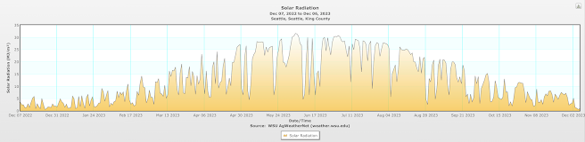
Below is a plot of incoming solar radiation from the WSU AgWeather network site in Seattle (near the UW) over the past year.
The last two days have been abysmal, with 0.57 and 0.87 MJ (megajoules) per square meter. During the midsummer we often get above 30.
To put it another way, during mid-summer we can get around 50 times more warming rays from the sun than during the past few days.
The trouble is that we start with a relatively northerly latitude with short days.... so there is meager solar radiation to start with.
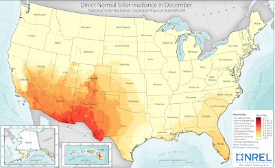
The combination of weak sun, short days, and plentiful clouds makes solar energy problematic in our region during the winter. Take a look at the average solar resource (the fancy name is irradiance) for December. Not much in the Northwest. A different (and better) story over the desert U.S. southwest.
Weather forecasting models predict solar radiation reaching the ground, something I have never shown in the blog until today. But now I will give you a peek!


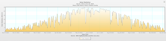
What about Pasco in the Columbia Basin? Surely that location would be brighter! (see below).
Nope, the same story.

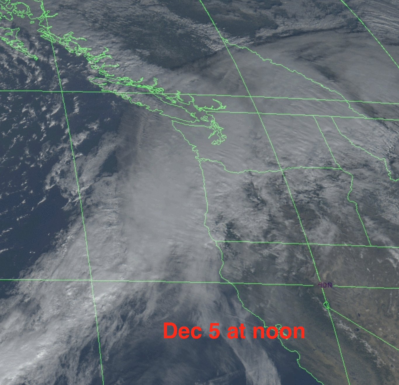
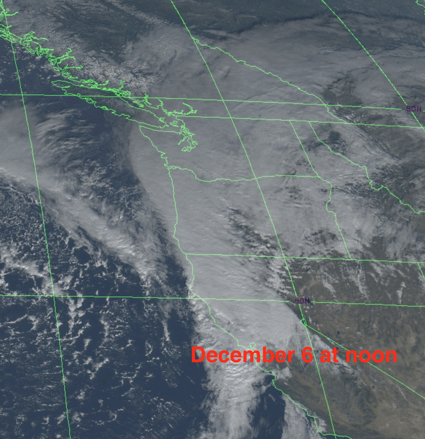
Then we add very thick, deep clouds from a strong atmospheric river. Plus lots of precipitation. The visible satellite imagery at noon for December 5 and 6 are shown below. The atmospheric river/frontal clouds are clearly visible and had spread over both sides of the Cascades.

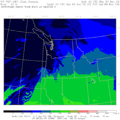
The forecast for 1 PM today shows dark colors (less sun) over the region with the murk being particularly bad over the western slopes of the Cascades.

Saturday looks better in northern CA, but far worse in western Oregon and Washington. Why? Because ANOTHER atmospheric river is coming in.

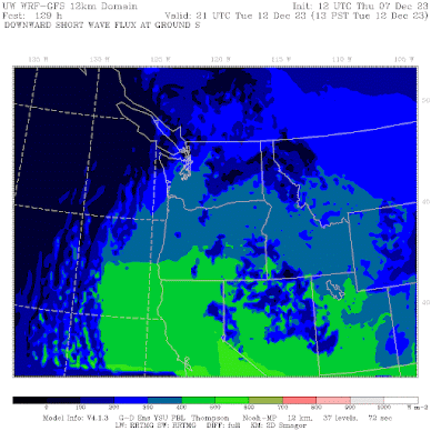
Want solar relief? It will be much brighter on Tuesday (see below) as a ridge of high pressure builds (temporarily) over the eastern Pacific.
Get your sunglasses ready.😊


Dr. Mass I graduated from Washington State University and one year when the Apple Cup was in Seattle, we parked on the east side of that large greenbelt that's located just east of Montlake Boulevard, in the parking lot of the WSU facility I think you're referencing. I recall at the time thinking "We Cougs really are EVERYWHERE!" I realize WSU and UW collaborate on various projects all the time, but I've never seen any building anywhere remotely near the Pullman campus that is owned or operated by UW.
ReplyDeleteI love you forecasts, btw: you are the only one I trust to get it right without all of the hype associated with local media weather reports.
One of the reasons why I moved here was because of weather just like what we've been experiencing over the past ten days. Of course too much of a good thing can cause all sorts of serious issues, so an extended dry period would be welcome right about now.
ReplyDelete14 day forecast aside from this coming weekend is calling for nothing but dry n sunshine for Vancouver through till the 22nd. Is this a typical El Nino pattern, or is there a warm water blob giving us a persistent rex/omega block off the coast of BC this year? ... Aside from the recent atmospheric weather the entire Fall has been nearly as dry as Summer in BC.
ReplyDeleteNot quite. Although Vancouver has been drier than normal its nothing concerning as they've still had ample rain since mid October,and it doesn't compare to the summer months. It looks wetter for the north and Central BC coast in the coming weeks too. This is a moderate El Nino, so expect a split flow, ridge pattern off the BC Coast. That's totally normal in a moderate El Nino. If it were a strong El Nino then southern BC would get some more of the energy from storms mainly going into California and Oregon. This will be a lousy ski season but that's expected although it shouldn't be as bad as 2014-15.
DeleteNew lyrics to an old 1970's tune:
ReplyDelete-----------------------------------------
We can never know about the rain to come
But we think about rain anyway
And we wonder if we are really here now
Or just chasin' after some sunny day
Precipitation, precipitation
Is makin' us late
Is keepin' us waitin'
And I tell you how warm the sun feels on my face
And how right its warmth feels around me
But I, I rehearsed those words just late last night
When I was thinkin' about how warm today might be
Precipitation, precipitation
Is makin' us late
Is keepin' us waitin'
And tomorrow we might not be warmer
We're not prophets and we don't know nature's ways
So we'll try and see into the forecast right now
And stay right here 'cause these are the good weather days
And stay right here 'cause these are the good weather days
Snow here in Seabeck as shown for a few days on the UW WRF model. We'll see if we get several inches as the model shows
ReplyDeleteSilly as solar is in Washington (plenty of power when nobody needs it, none when we do!) Huge solar arrays from the Texas panhandle to Baja and an HVDC line to the east coast would be amazing for time-shifted power exports.
ReplyDelete