It often happens the second or third week of August. After weeks of dry, warm weather or perhaps some summertime thunderstorms, that first Pacific frontal system of the season with substantial clouds and some light precipitation reaches the Northwest coast. And it is happening right now.
Take a look at the infrared satellite picture at 1 AM today (Wednesday)--you can see the the frontal cloud band stretch northward just offshore our coast towards Vancouver Island and then out to the west.
And the radar image from Langley Hill near Hoquiam showed a nice offshore precipitation band associated with the front.
The official National Weather Service surface analysis indicates a low center and fronts offshore.
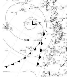
This system is rapidly falling apart and most of you won't see much more than a few sprinkles and lots of clouds. But it is serves as our first warning of the upcoming fall.
The return of precipitation this time of the year is quite evident in the daily climatology at Northwest weather stations. For example, here is a table produced by Mark Albright, past WA State Climatologist for the precipitation and other parameters at Seattle Tacoma Airport. The mean daily precipitation (next to last column) of .02 inches during the first 12 days of the month, nearly doubles around the 15th. More impressively, the frequency of measurable precipitation goes from 11-15% in the beginning of the month to roughly 25% at the end, with the big transition occurring between the 12th and 24th on average.
Don't get too depressed by this...summer is not over and we often have glorious Septembers. But changes in the Northern Hemisphere's weather pattern is now becoming evident and we are leaving the optimal period of warmth and dryness that is so dominant the last week of July and the first week of August.
This blog discusses current weather, weather prediction, climate issues, and current events
August 14, 2013
August 12, 2013
Heavy Thunderstorm Rain Closes State Route 20
The eastern slopes of the Cascades are susceptible to very heavy thunderstorm rains during the summer and on Saturday night it happened again.
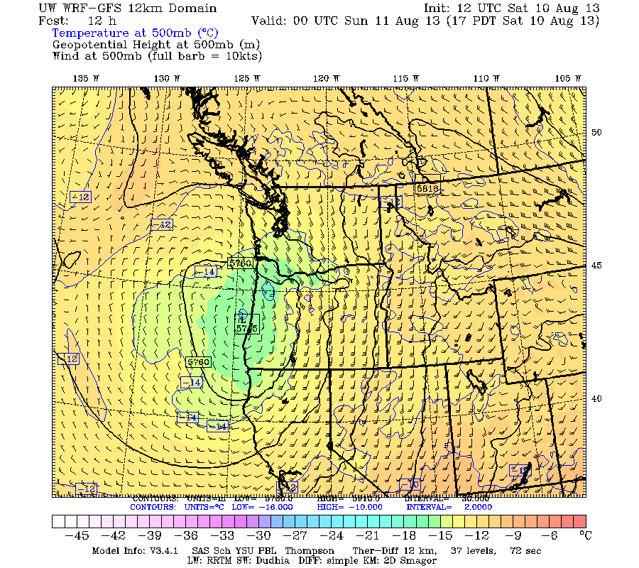
On Friday through Sunday, the region was covered by a moist, relatively unstable air mass that brought strong thunderstorm activity and lots of lightning. The proximate cause was an upper level low that was slowly moving up the coast, resulting in southeasterly flow in the lower atmosphere (see 500 hPa map, roughly 18,000 ft, for Saturday at 5 PM below).
As the moist air approached the eastern slopes Washington Cascades it was forced to rise and instability was released, producing lots of thunderstorms, some with intense rain and much lightning. A particularly, intense thunderstorm cell passed across the North Cascades between 8 and 10 PM Saturday, here is a radar image for 8:49 PM Saturday. Red indicates very heavy rain.
Not impressed yet? Here is a higher resolution radar image (from Camano Island radar) five minutes earlier (8:54 PM). WOW. Look closely and you will see the color blue in the center of this storm. Very rare. The figure indicates the highest composite reflectivity (the highest reflectivity in a vertical column) was 69, which is associated with hail and torrential rain. You will also notice more showers to the south.
How high was this monster? The radar suggested about 40,000 ft, very high for our neck of the woods (see figure)
There were no surface observations under that storm. But we can see the total precipitation for the entire thunderstorm period (based on radar) in the following figure. Keep in mind that radar-based precipitation totals are rough estimates and that the north Cascades blocked a lot of the radar echo. Clearly, the eastern side of the Cascades was hammered, with some places getting 4-6 inches over a several day period. I cannot imagine what happened under that intense thunderstorm over the North Cascades.
With rain wetting the soil over the past day and then being hit by a deluge that certainly was well over an inch in an hour, there were mudslides and debris flows over portions of the north Cascades, including a section of State Route 20. That road was covered with mud, rocks, and trees--in some places as deep as 25 feet. WSDOT has closed the SR 20 from mile markers 147 to 157. Take a look at some of the amazing photos provided by WSDOT personnel. You got to appreciate the folks at WSDOT, having to deal with massive slides like this and collapsing bridges on I5.
In my book, I talk about several other eastern slope thunderstorm road closures and landslides, such as the 1998 and 2012 events on the Yakima Canyon road (SR 821).
The eastern slopes of the Cascades is a very beautiful and bountiful place (fragrant pine forests, apples, wind power and more), but it also has its vulnerabilities, including intense thunderstorms, powerful downslope winds, and lightning-induced wildfires.
On Friday through Sunday, the region was covered by a moist, relatively unstable air mass that brought strong thunderstorm activity and lots of lightning. The proximate cause was an upper level low that was slowly moving up the coast, resulting in southeasterly flow in the lower atmosphere (see 500 hPa map, roughly 18,000 ft, for Saturday at 5 PM below).
As the moist air approached the eastern slopes Washington Cascades it was forced to rise and instability was released, producing lots of thunderstorms, some with intense rain and much lightning. A particularly, intense thunderstorm cell passed across the North Cascades between 8 and 10 PM Saturday, here is a radar image for 8:49 PM Saturday. Red indicates very heavy rain.
Not impressed yet? Here is a higher resolution radar image (from Camano Island radar) five minutes earlier (8:54 PM). WOW. Look closely and you will see the color blue in the center of this storm. Very rare. The figure indicates the highest composite reflectivity (the highest reflectivity in a vertical column) was 69, which is associated with hail and torrential rain. You will also notice more showers to the south.
How high was this monster? The radar suggested about 40,000 ft, very high for our neck of the woods (see figure)
There were no surface observations under that storm. But we can see the total precipitation for the entire thunderstorm period (based on radar) in the following figure. Keep in mind that radar-based precipitation totals are rough estimates and that the north Cascades blocked a lot of the radar echo. Clearly, the eastern side of the Cascades was hammered, with some places getting 4-6 inches over a several day period. I cannot imagine what happened under that intense thunderstorm over the North Cascades.
With rain wetting the soil over the past day and then being hit by a deluge that certainly was well over an inch in an hour, there were mudslides and debris flows over portions of the north Cascades, including a section of State Route 20. That road was covered with mud, rocks, and trees--in some places as deep as 25 feet. WSDOT has closed the SR 20 from mile markers 147 to 157. Take a look at some of the amazing photos provided by WSDOT personnel. You got to appreciate the folks at WSDOT, having to deal with massive slides like this and collapsing bridges on I5.
In my book, I talk about several other eastern slope thunderstorm road closures and landslides, such as the 1998 and 2012 events on the Yakima Canyon road (SR 821).
The eastern slopes of the Cascades is a very beautiful and bountiful place (fragrant pine forests, apples, wind power and more), but it also has its vulnerabilities, including intense thunderstorms, powerful downslope winds, and lightning-induced wildfires.
Subscribe to:
Posts (Atom)
Are the Recent Northwest Wildfires a Sign of Global Warming? The Science Says No
During the last few weeks, a series of wildfires have occurred over the region. Today's satellite imagery shows where the fires were bur...
-
Today may be the last day you will need air conditioning this summer in western Washington. And fears of wildfires west of the Cascade cres...
-
For those worried about Pacific Northwest drought, I have some news that should give them substantial comfort: substantial rain and snow wil...