March 17, 2016

Was Sunday's Storm Like a Hurricane?

Several media outlets have described last Sunday's blow as similar to a hurricane.   Is that true?   Are there any similarities of our modest windstorm with hurricanes?  Let's check it out.


First, let me start with an impressive water vapor satellite image that shows the amount of water vapor in the upper troposphere, with green being the most, followed by white, gray and black. Amazing spiral, with intervening layers of moist and dry air spiraling in towards the center.


The infrared satellite picture (giving the temperature and thus the height of the clouds) shows the spiral, with the speckled clouds indicating cold air moving into the system.


The structure of hurricanes is radically different.  There is no spiral of moisture into the storm, no dry air or cold air spiraling towards the center.   Rather, there is a relatively uniform area of high moisture values associated with the eye wall clouds and the moist surroundings.   Here are two examples from real hurricanes.


Hurricanes form over tropical waters and require a warm, moist environment....dry and cold air spiraling towards the storm center would kill it.

Then there is the energy source of the Sunday storm and hurricanes.  Very different.  Midlatitude storms derive their energy from horizontal temperature contrasts (or gradients).  Hurricanes need warm water (more than roughly 80F), which provides both sensible heat and moisture.    You know what the temperature of the eastern Pacific off our shore is right now?  As shown by the NOAA  sea surface temperature map, around 10C (50F).   No true hurricane could survive over the northeast Pacific.


Hurricanes have sustained winds exceeding 64 kt (74 mph).  Sustained winds NOT gusts.  During the height of our storm, the strongest sustained winds were roughly 25-35 kt, with a few locations with the best exposure (like West Point, Seattle) getting into the 40s kt.  Not even close to hurricane levels.  For example, at the extremely well exposed UW Atmospheric Sciences site (on top of a 7 story building), sustained winds only reached around 25 knots (see below), with gusts hitting about 40 knots.


I could provide more illustrations and reasons, but the facts are clear.  Sunday's storm was not a hurricane, did not have winds even close to that of a hurricane, didn't have the structure of a hurricane, and derived it energy from a very different source.  Completely different animal from the tropical hurricanes striking the SE U.S.

Yesterday I talked to an experienced arborist, who told me that one reason so many trees fell during this event was due to the extraordinary saturation of our soils after the wettest winter in Seattle history.

March 15, 2016

Stampede Pass Weather Station is Back!

There was delightful and important news today:  Stampede Pass weather station in the central Washington Cascades is back online after being unavailable for much of the past few years.


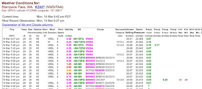
Stampede Pass is probably the most valuable of all of the National Weather Service first-order ASOS sites.  No Weather Service site is more isolated, miles from any paved road.  Stampede not only has the typical surface observations, but also possesses a laser ceilometer that describes the height of the cloud base above (which is very useful for pilots flying across the mountains).

In addition, Stampede Pass has a horizontal visibility sensor, a freezing rain sensor, and precipitation-type identifier.  No other location near the Cascade crest has such a wide range of observing capabilities.


Let me show you a sample of observations from Stampede on Monday night...


Stampede Pass is also very valuable for climate studies, since there is no urbanization anywhere nearby.   Here is the plot of the surface temperatures over the past 20 years there.  I will let you decide if there is any global warming signal.

We should all be thankful for the substantial efforts of the National Weather Service in getting this critical observing location back online.    The key problem was communication, with the repeated loss and degradation of the telephone line to the site.  Fortunately, there was a good cellular signal and that allowed the use of cell modem, AFTER they figured how to interface an ancient 9600 baud modem to a modern communication system.   Clearly, the National Weather Service needs to invest in updating the 30-year old communication hardware found in their primary observing system around the nation.

The Puget Sound Convergence Zone Delivers and Well-Timed Precipitation and Smart Water Management Keep Yakima Crops Yields High

Before I get into the Yakima Valley situation, let me note yesterday's substantial precipitation over central Puget Sound from a decent ...