December 22, 2021

An Incredible Cold Wave is Being Forecast

 Forget the snow.  

There will be lots in the mountains and some limited lowland areas will get a few inches of the white stuff as well.

It is the extreme cold you need to pay attention to.  

Back in June, I couldn't believe the extreme conditions the models were forecasting--including both daily and all-time records.   The models are doing it again, but this time for record-breaking cold.

Cold enough to kill those attempting to live outside without shelter--making it mandatory to get all homeless inside no later than Saturday.

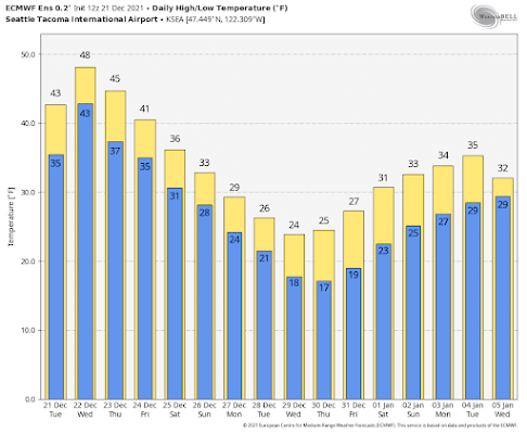
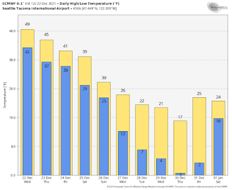
Consider the surface air temperature forecast from the European Center global model for SeaTac Airport.  After Saturday, high temperatures will remain below freezing for at least a week, with December 30th having a high of 17F and a low of -1F, which would be the ALL TIME RECORD LOW FOR ALL TIME FOR SEATTLE.

What about temperatures in Seattle forecast by the University of Washington system run by my group (see below)?    I really can't believe it.  Temperatures dropping to nearly zero and below on several days.

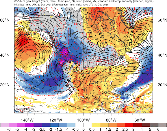
The temperature difference from normal (anomaly) at 850 hPa (about 5000 ft) for the National Weather Service GFS model for 4 AM 30 December (courtesy of Dr. Alician Bentley) is very, very unusual (light purple colors)--essentially unprecedented over the past 40 years.


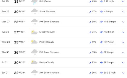
The forecast of Weather.com, which is usually excellent but typically conservative this far out, is going for low temperatures dropping to 16F (see below).


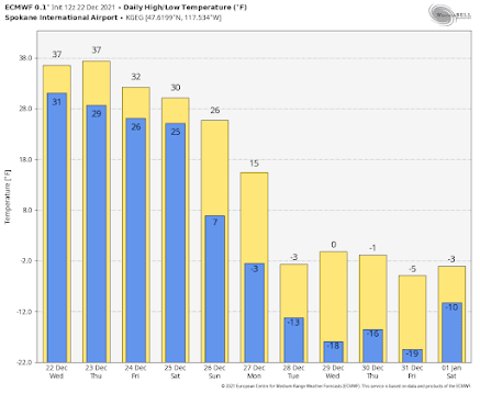
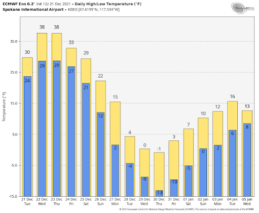
And western Washington will be torrid compared to eastern Washington, where temperatures will drop below -15F at many locations (see Spokane's forecast below)
--


There are still uncertainties in the forecast for Sunday and below, but at this point, it is safe to say that the region will experience some of the coldest temperatures in 5-20 years and if the crazy forecasts come true, many locations will break daily records, a number will break monthly records, and some potentially all-time records for cold.

Snow would be a godsend since it would help insulate plants from the cold.  Can you imagine cold damage on top of heat damage last summer?

Stay tuned, but prepare.


December 21, 2021

Extraordinary Cold in Store for The Pacific Northwest

It will not be a little ironic that a year that brought record-breaking high temperatures in June, also brings extreme cold in December.

But life is full of contradictions and ironies.....

The latest model runs suggest that immediately after Christmas temperatures will plummet to levels not seen in our region for perhaps decades.

Let's begin with the European Center ensemble forecasts....averages of many runs from the best global prediction center in the world.

For Seattle-Tacoma Airport, highs only reaching the mid-20s, and lows in the teens--something we haven't seen in several years.  A totally hard freeze.


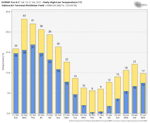
In Yakima, highs reaching only the single digits and lows plummeting below zero.


And do I dare show you the forecasts for Spokane?  Where one day never gets above zero?


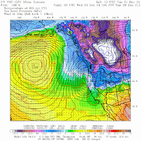
The surface forecast for 4 PM next Tuesday is one of extremes.

Extreme high pressure over the northeast Pacific.
Extreme cold (white and purple colors) over the interior of BC and just east of the Rockies.
And frigid temperatures (blue colors) over the Northwest.


White Christmas in the Lowlands?

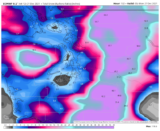
Maybe not on the ground Christmas morning.  But the chances for snow AFTER Christmas looks favorable.  The total snowfall (not accumulation) through Sunday at 4 PM is roughly 2-4 inches around Puget Sound.   More on that in future blogs, particularly since there is still considerable uncertainty in the snow forecast.

But you can bank on cold air coming...so get ready.  

Outdoor faucets should have hoses removed.  Pets should be moved inside.  And local agencies have to get homeless folks off the streets...this period will be cold enough to be life-threatening.


The Smoke Situation is Rapidly Improving West of the Cascade Crest: But the Wind Threat to the East Remains

 As expected, air quality is rapidly improving west of the Cascades, with the transition complete by tomorrow morning. You can see the chang...