January 15, 2022

The Tonga Volcano Affects the Weather and Water of the Pacific Northwest

Yesterday, around 0400 UTC 15 January (8 PM PST 14 January), there was a massive, explosive eruption near Tonga, in the southern tropical Pacific, about 5642 miles from Seattle (see map).

The volcano was clearly evident in satellite imagery from the massive ash cloud (see below, about 1-h after the eruption)


The explosive eruption created shock waves in the atmosphere (pressure waves) that rapidly propagated away.  These waves are evident in some infrared (water vapor channel) imagery as concentric rings (shown below).


The oceanic eruption also pushed away a massive amount of water, which created a tsunami on nearby islands (such as Tonga) and deep water waves that moved away at the speed of a jet plane, reaching the West Coast this morning.  This is why some local tsunami warnings went out this AM.

The Pressure Wave Reaches the Northwest

Local barometers indicated a well-defined pressure wave passing over our region around 4:30 AM this morning.  Here in Seattle, the University of Washington barometer showed the feature, with an amplitude of roughly 2 hPa (2 mb).  The arrow indicates the feature. Very impressive.


So it took about eight hours and 30 minutes to go about 5643 miles--thus a speed around 664 miles per hour.  

The water wave moves slower, around 400 mph (and occasionally approaching 500 mph)....so a later arrival was expected.   Thus, at Neah Bay, at the entrance to the Strait of Juan de Fuca,  the water wave arrived around 9 AM (17:00 UTC as shown on the chart), as indicated by the waviness in the water level after that time.  The amplitude of the variation is around 2 feet.


If you really want to be impressed, check out the same figure at Monterey, California.  Just wow.  The amplitude was up to 3-4 feet.
An amazing event and one that shows how interconnected our planet is--both in the air and in the water.

January 14, 2022

The Best Weekend in a Long Time, Major Ridging Ahead, and the Mid-January Break: All in My New Podcast

After one dismal weekend after another, relatively dry conditions are ahead--thanks to persistent ridging--high pressure--over the northeast Pacific. 

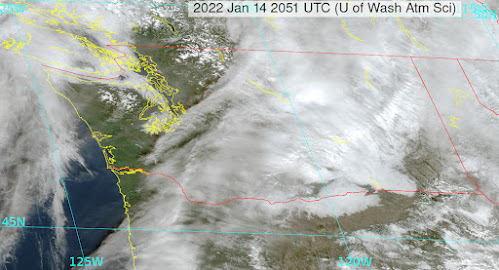
The visible satellite image around noon shows sun reaching the surface for much of western WA, with the exception of fogged in areas near the water.   Lots of fog and middle clouds still over eastern WA.


A ridge of high pressure will develop aloft over the weekend (see map at 500 hPa...about 18,000 ft/..on Sunday morning below), leading to dry conditions and normal temperatures over much of the region.  But the ridge will not be strong enough to keep middle-level clouds away or precipitation from British Columbia.


Monday should be relatively dry until a moderate front approaches late in the day.

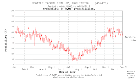
Check the podcast for more details on the forecast....and an explanation of the typical mid-January drying of the region--illustrated by the probability of measurable precipitation at Sea Tac below.


You can listen to the podcast below or through your favorite podcast server.


Some major podcast servers:

 HTML tutorial HTML tutorial
Like the podcast? Support on Patreon 


Rain and Snow on the "Wrong" Side of the Mountains

Examine the climatological precipitation map for Washington State, and the heaviest precipitation is on the western slopes of the Cascades a...