February 11, 2024

Why does El Nino Influence West Coast Weather?

As I have noted in a recent blog, it is no surprise that the low snowpack and warm temperatures have occurred over the Northwest during the past month or so.

This is a very typical pattern during El Nino years.

In particular, during El Nino years, when the tropical Pacific is warmer than normal, we often experience low pressure off the West Coast, with storms shunted into California.

To illustrate the current situation, here is the difference from normal of sea level pressure for the past two months.  You can see the anomalous low pressure to our southwest.

This pattern pushes the jet stream south and leaves California wetter than normal.  But their boom is our bust.

But why does El Nino set up this pattern?

Why do warm sea surface temperatures in the tropical Pacific associated with El Nino alter the pressure and wind patterns off the West Coast.

The answer to this question was found in the late 1970s and early 1980s by two researchers at the UW:  graduate student John Horel and Professor Mike Wallace.

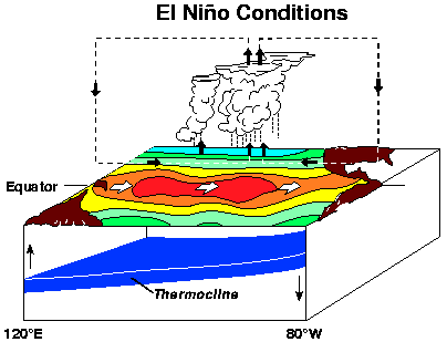
First, the warm waters of El Nino (illustrated by the shaded area near the equator) perturb the atmosphere above.  

How?  By creating lots of thunderstorms over the warm water.  Thunderstorms that inject huge amounts of energy into the atmosphere (see below).

 A series of waves....called Rossby Waves...then propagate into the midlatitudes, causing a series of low and high-pressure pressure areas (note the L's and H's in the figure in the figure below). 

 The jet stream....the current of strong winds in the upper troposphere... is distorted by this wave pattern (see the arrows in the figure).  This pattern is generally associated with low pressure off the northern CA coast.

This situation is analogous to throwing a rock into a stream, with waves propagating away from where the rock hits the water.  

In the atmospheric case,  big thunderstorms above the warm water act as the "rock,"


During the next few months as El Nino makes way for La Nina, the central Pacific water will cool, the thunderstorms will shift westward, and the wave pattern change substantially.


February 09, 2024

Precipitation Returns to the Pacific Northwest

There is some nervousness about the water situation in some quarters because of the current El Nino situation.

But although El Ninos tend to produce lower snowpack and warmer temperatures, the total precipitation is much less impacted.  Consistent with this, several wet systems are expected during the next week.

On Sunday, a wet system will move into the region,  providing welcome precipitation over the region, including heavy stuff over southwest BC.

This will be snow over higher elevations (above 4000 ft).

Another moist system will come in on Wednesday associated with a Pacific warm front (see below), with bountiful snow in the mountains.


The forecast over the next ten days, based on the European Center ensemble model, suggests copious precipitation over southwest BC and substantial amounts along the entire coast. 

 This is not a drought situation by any means.  In fact, California will be in an excellent situation regarding water supplies.


The US Army Corps of Engineers and others controlling our local dams/reservoirs will hopefully store as much of this wet bounty as possible.   They can do this because the weather models do not suggest any dangerous flooding situations for which they would need to draw down water levels.

And for those worried about water and climate change, here is an interesting factoid.   

There has been no decline in spring precipitation over the past several decades.  In fact, just the opposite:  the trends have been positive.

For example, here are the spring precipitation totals back to 1947 at SeaTec.   Upward trend (brown line).

Or consider Yakima, amid prime agricultural land in eastern Wa (below).  Also getting more moist.


So perhaps the talk of "languishing"  and  "little hope" should be put on the shelf somewhere.


The Great Cooling Has Started

The Pacific Northwest has begun the late summer cooling period, with a substantial cooling occurring over the entire region. A cooling that ...