Yesterday some people were reporting some very strange things. Some mentioned flying ferry boats and others looked across the Sound to see weirdly looming shorelines. Here is a nice picture sent to me by Greg Johnson, who runs a wonderful weather site:
http://www.skunkbayweather.com/ with observations and cam/video shots from his location the on the Kitsap Peninsula.
Looking across the shore you see a strange sight...it looks like there are high cliffs on the opposite shore! And there aren't any.
So what is going on?
It is called a superior mirage and yesterday was the best day in a long time to have one--and the place to see it would be near the water. The most frequent set up for superior mirages is when there is a layer of cold air near the surface and warmer air right above. Puget Sound and most of our water surfaces are quite cool--roughly 50F--while we had quite warm air aloft--70s and even lower 80s in few locations. So we had cool, dense air immediately next to the water and warmer, less dense air aloft; this situation acts as a lens that causes objects over the water or on the distance shore to look bigger (see graphic below). My book has a large section on this and explains in more detail
Superior (or towering) mirages can not only elevated objects, but can invert them too--or both! Here is a neat video of a superior mirage with the full-meal deal:
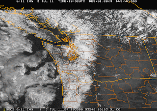
July 4th update on Sunday. After getting into the 70s and lower 80s yesterday, aweak front has cooled things down quite a bit--at noon on Sunday, upper 50s and lower 60s are the rule. Lots of clouds on the windward Cacasde slopes and in the Puget Sound convergence zone...but LOTS of sun over the San Juans and the south Sound, and of course eastern WA--check out the latest visible satellite picture:
Very little on the radar. Very nice weather the whole week. Summer is here. Winter is over. At least for a few days.
This blog discusses current weather, weather prediction, climate issues, and current events
Subscribe to:
Post Comments (Atom)
Contrail Fest over Eastern Washington
The satellite imagery over eastern Washington this morning looked like someone had gone crazy with a white crayon, drawing many white lines...

-
Today may be the last day you will need air conditioning this summer in western Washington. And fears of wildfires west of the Cascade cres...
-
Over the eastern U.S., the passage of a strong cold front, with a rapid decline of surface temperature, is a frequent winter treat. In contr...


Very cool photos / video. Sadly - the inversion traps not only light, but also pollution, which doesn't rise into warm layer above the ocean - being that it's cooler and thus more dense... and which can be a concern for boaters and whales.
ReplyDeleteThis comment has been removed by the author.
ReplyDeleteLove the new format! I saw a mirage on Lake Sammamish and wondered WTF. Thanks for the information!!
ReplyDeleteCool new format. But can you put back the links to NWS and Probcast?
ReplyDeleteWhen I look into the mirror in the morning, just after I wake up, and my vision is still a little foggy - would that be called an "inferior mirage"?
ReplyDeleteKW
Cliff, is it the inversion that magnifies Mt Rainier when driving south on the 405 north of exit 26? There's a spot when you can first see the mountain and it looks so much bigger than it does when we get home, in Kirkland, off of 160th st.
ReplyDeletewow nice background image Cliff !!
ReplyDelete