During the past few weeks we have had really decent weather--generally dry, with periods of above and below normal temperatures.
Such variability, centered around climatological temperatures, is what normal is all about.
There has been enough sun and warmth for a miracle to happen---I actually have red, ripe tomatoes! Few pleasures in life are greater. Here is the proof:
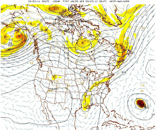
Well, another miracle is occurring...we are going into a warm up period through the weekend and then the heat really revs up on Tuesday and Wednesday as a monster ridge builds up over the western U.S. And it just stays in place forever.
Right now a weak trough is moving through, bringing increased cloudiness over the region. Tomorrow (Friday) we should wake up to clouds, but they should break up during the afternoon...low to mid 70s. But on Saturday ridging aloft develops (see upper level chart) and the temps warm with more sun. Perhaps a bit warmer on Sunday.
But early in the week ridging really develops (graphic) and temperatures could hit the mid 80s.
And do you see that features in the lower right...another hurricane. The NWS GFS model has this storm approaching the East Coast late Friday (see forecast for Friday AM below) but the forecast will surely change. The latest solution gets the hurricane/tropical storm close before it swings to the NE off of New England.
The NWS Climate Prediction Center is suggesting increased probabilities for above normal temperatures through next week. (see graphic).
No fried green tomatoes for me!
Just a reminder...will be starting my KPLU weather segment tomorrow (Friday) at 9 AM...right after birdnote.
This blog discusses current weather, weather prediction, climate issues, and current events
Subscribe to:
Post Comments (Atom)
The Origin of the Puget Sound Tornado
Around 3 PM on Wednesday, a tornado was spotted over Puget Sound (see picture below). Technically, this rotating wind feature is known as a...

-
Today may be the last day you will need air conditioning this summer in western Washington. And fears of wildfires west of the Cascade cres...
-
Over the eastern U.S., the passage of a strong cold front, with a rapid decline of surface temperature, is a frequent winter treat. In contr...


I've always loved the NW weather in September. And even sweeter this year as the summer has felt like a series of one night stands. Each sunny day a treat, but all the more disappointing when the clouds and damp chill return by morning.
ReplyDeleteRipe enough for "to market" maybe Cliff. But for main "vine-ripe" tomatoes, you should have left those "beauties" on the vine for a few more days, at least.
ReplyDelete— Mark this idea perhaps, for trial. Main harvest, for any, either whether fruiting vegetables - tomatoes, as well as summer squash, eggplant, for a few other examples (.. peppers.), or either, main fruits - all., is between 1st quarter, and full moon. For reference sake, at this point - more specific, it's only a few days past new moon. http://www.jgiesen.de/SME/
This weather sounds excellent and I hope it means that the tomatoes that are staying stubbornly green on the vines will begin to change color.
ReplyDeleteHopefully this warm spell also means that we will hit 80 degrees up north around Mt. Vernon. Our high for the summer has still only been 78. Usually my weather station records 5-8 days of 80 degrees and it would make me happy if we recorded one this year.
Professor Mass, enjoyed your segment on KPLU a minute ago. Reminded me of the talk you gave at City Hall earlier this year. I'll be following Katia this weekend...
ReplyDeleteFitting that your first forecast discussion on KPLU was sunny and warm. Well done.
ReplyDeleteIt also would be fitting if the blog readers mentioned Cliff on their upcoming donations to KPLU.
As one who wrote to KPLU to snap you up right away (and sure I'm not only KPLU listener who did so), I am delighted you will be back on the air. Placed after bird note seems just right. Enjoy.....and so will we.
ReplyDeleteCliff:
ReplyDeleteCheck out the MODIS and see if the smoke plume from the Olympics is visible. It looks like it is in the Duckabush River valley and the smoke is rising and blowing directly west, it would seem.
Liking this warm, sunny weather. Picked our tomatoes today!
ReplyDeleteOT, maybe,... but which tomato variety is that? Our tomatoes (other than the sungold) are struggling, almost no ripe ones yet. Yours look beautiful!
ReplyDeleteLast night while riding on the ferry from Edmonds to Kingston at sunset, the smoke from the Brinnon Fire was very evident. What would be the scientific explanation about why the smoke does not continue to rise, but seems to reach a ceiling and then move in the direction of the prevailing wind? Probably most 5th graders know the answer, but I don't.
ReplyDelete