By that I mean: how far into the future can we forecast specific weather features--perhaps the intensity and position of a low pressure center or the position of a front or whether they will be rain during the early morning hours. Such forecasts contrast with climate prediction, where we attempt to predict the general nature of the weather over a period...say the average temperatures for the spring.
Lately we have increasingly seen forecast skill extend well past a week...and in some cases, extending to nearly two weeks....and in this blog I will show you a few examples.
A lot of research was done on this topic--determining the limits of predictability-- both from theoretical and modeling perspectives. For example, meteorologists such as Edward Lorenz and Joseph Smagorinsky would run weather forecast models many times, each starting from a SLIGHTLY different beginning--well within observational error. They would see how long it would take before the forecasts would become very different. Generally, it took about two weeks, but there is nothing unique about that period. Sometimes forecasts would diverge after a few days, while in other situations the forecasts held together much, much longer. The implication is that during some periods we find that forecast skill, even with a perfect forecast model, is lost quickly, while in other periods we might skillfully predict the weather for weeks.
In the early days of forecasting, when our forecast models were crude and our observational resources were few, weather prediction could not get close to the theoretical limits. But during the last decade or so, with the availability of satellite data, fast computers, and far better computer models, prediction skill has extended further and further out in time. In the 60s-80s we were lucky to skillfully forecast out 2-3 days. In the 90s 3-4 days. And in the 2000s, 4-5 day forecasts were often quite skillful. But recently, we have seen highly skillful forecasts consistently at 5-7 days, and occasionally approaching two weeks.
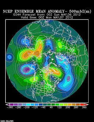
Want to see some examples? Here is a 360 hr forecast (15 DAYS) from a National Weather Service ensemble weather prediction system for the height of the 500 mb pressure surface. Specifically, it shows the predicted anomaly (difference) from normal of the mean of a large collection of forecasts (the ensemble). Note the HUGE (orange color) high height anomaly in the north Pacific.
Next, here is a 192 hour (8 day!) forecast valid the for same time. The feature is still there.
Finally, here is a 24-hr forecast verifying at the same them..this should be pretty much exactly what happened.....the feature is still there...albeit distorted a bit. You will note that the 192 hour forecast
got a number of other features correct...or nearly correct...as well.
Or examine the 240 h (10 day) forecast by the European Center for Medium Range Forecasting and compare it to the 24 hour forecast for the same time. The images below show 500 hPa heights and 850 hPa (around 1500 meters) temperatures. Not perfect, but a number of features are very similar...useful forecast skill there!
Or a recent example--a forecast at 500 hPa made 7.5 days ago for today at 5 PM....and a 12-h prediction for the same time. A lot of the same features, although there are some minor differences in phasing and amplitude.
The general consensus is that we will see such skill extend out further in time, by at least one day per decade. There is a limit to this extension of forecast skill...but there is much we can do to improve our predictions more--so improvements should continue for a while.
So when people ask you how far into the future meteorologists can predict the weather, a good answer is:
2-3 days with excellent skill
3-4 days with moderate, but useful skill
5-6 days with marginal skill
..and occasionally skill extending out 7-10 days.
Yes...sometimes forecasts go wrong in less than a day...but is considerably less frequent than a decade ago.


While I agree that things have gotten better in the mid-range forecast horizon (in relatively stable pattern setups); I also believe it is a bit short-sighted and self congratulatory to tout these as overwhelmingly successful mid-range examples. From the viewpoint of a meteorologist I think these do appear to be solid examples of good weather prediction, but to the person on the ground (especially in the Mountain West and Pacific Northwest) those slight variations in phasing of troughs and amplitude of ridges, or longitudinal placement of the ridge often mean all the difference in the world with respect to the 'weather' even if the 'pattern' is correct. A flatter dirty ridge with filtered sun can mean a 10 degree miss temp-wise, even though we are still under a ridge of similar form (big deal when talking about WA's #1 killer in the wintertime; road icing). Additionally, we still have a long road ahead, developing skillful mid-range prediction when it matters most; during rapidly evolving weather patterns (Think snow-storms, thunderstorms, even hurricanes). While it's true that we've managed to more skillfully forecast large patterns , we remain comparatively inept when it comes to mid or long range point-prediction of medium/high-impact weather . If we in the met community are going to truly pat-ourselves on the back and call a mid-range weather forecast skillful, it needs to be so in all or at least MOST weather patterns. I'm just not so sure we're there yet.
ReplyDeleteMatt
I'm relieved to know I can put more faith into the long-range forecasts I read at NWS. Thanks Professor!
ReplyDeleteLooking at the forecast now, it looks like we're in for dreary days for a while. Would you say June Gloom has set in?
If a butterfly has such a significant effect just imagine what happens when there is an outbreak of the flu. All those people sneezing must cause havoc to the weather forecasts.
ReplyDelete