As the U.S. West Coast enters the warm season, one area is getting very windy, particularly during the afternoon and evenings. Day after day this region will be hit by 20-30 mph winds, often with higher gusts. A region, where the afternoon is often too windy to be on the beach, with wind-driven sandy stinging and making life unpleasant. Give up?
It is the coastal zone stretching from southern Oregon into northern California, and out a hundred miles or so into the ocean.
Here is the sustained wind forecast of the UW WRF model for 5 PM this afternoon. Notice the greenish area along the West Coast, with sustained winds of 30 kts or more?
Now examine the closer view from the 12-km domain. Strong northerly winds stretch from just north of Brookings, Oregon (on the southern OR coast) to just north of San Francisco. You will also note a large change in sea level pressure over than area (solid lines), which has a lot to do about why we have strong winds there.
So why the strong winds in this area during the warm season? In the spring the East Pacific High strengthens and moves northward. At the same time, the desert southwest of the U.S., warms and pressure falls. So with rising pressure over the NE Pacific and falling pressure over the U.S. Southwest, an area of very strong pressure difference develops between them....over northern CA and southern Oregon. Large pressure differences result in strong winds.
But as the infomercials always say, WAIT, THERE'S MORE! The area of large pressure difference produces northerly winds over the coastal ocean, which in turns leads to upwelling...water coming up from below in the coastal ocean. Those upwelling waters are COLD. So we have very cold water offshore, and the land gets warm during the day. The result is a large temperature gradient (peaking during the warmest time of the day), which enhances the pressure gradient even more, producing a super sea breeze. So the morning is windy, but the afternoons are savage.
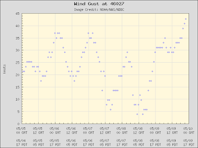
Lets take a look at the coastal winds for the past few days. Here are the peak gusts at Buoy 46027...just offshore of the CA/OR border. Wow...winds right now are gusting to NEARLY 45 knots (52 mph).
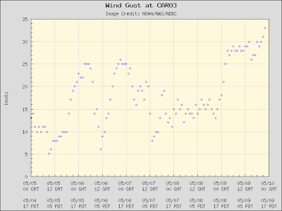
Or how about Cape Arago, Oregon (not far from North Bend)? Almost 35 knots over land. Can you imagine what that would be like on beach? Similar winds are also found at Crescent City, CA (see below).
The northerly summer winds are so strong along the southern Oregon coast that a lot of trees are bent southward. Want proof? Check out this picture taken at Brookings:
I better stop before I get into trouble with the Brookings, Oregon Chamber of Commerce. You might think this would be a good area for wind turbines, but the lack of transmission facilities and excessive strength of the winds might make it a poor choice. But the cold water does help produce lots of coastal fog and that gives us the magnificent redwoods, which depend on fog drip for summertime water.
A reminder for those near Portland, Oregon...I will be giving a free public lecture on the Future of Weather Forecasting at the OMSI science center (more info to the right or here), at 10 AM on Saturday.
This blog discusses current weather, weather prediction, climate issues, and current events
Subscribe to:
Post Comments (Atom)
Major Forecast Failure
Weather prediction has become hugely more skillful during the past several decades, but there are still some failure modes. This week in wes...

-
Today may be the last day you will need air conditioning this summer in western Washington. And fears of wildfires west of the Cascade cres...
-
Over the eastern U.S., the passage of a strong cold front, with a rapid decline of surface temperature, is a frequent winter treat. In contr...


Wow, great tree picture! The wind power folks call that "flagging" and they search for it. The power which wind contains is proportional to the CUBE of the wind speed. I would suspect that the lack of transmission lines explains the lack of windmills. If I lived there, I'd already have my backyard windmill. Since high winds correlate with storms, the harder it blows, the warmer you stay!
ReplyDeleteGreat post. I didn't realize winds got quite so powerful down there.
ReplyDeleteAnd I am definitely planning on being at OMSI (for those not in the know it is the Oregon Museum of Science and Industry). I look forward to your talk and possibly getting to talk to you in person.
Cliff - I am not sure that tree picture is proof of anything. Look at the shadow of the trunk of the tree - it sure looks like it is in the same direction as the bend in the tree – to the south.
ReplyDeleteTough to tell for sure, but it sure doesn’t look right to me.
I don't think the sun would ever be in the northern sky and causing a shadow to be cast southward anywhere north of the tropics, much less in Oregon.
Love your blog; Loved your book.
Unknown....I took the picture early in the morning...it was leaning to the south..cliff
ReplyDeleteTo change the subject: I'm in Olympia, and the NWS 7-day point forecast is showing a low of 33F for tomorrow (Thursday) night, and a high of 82 (!) on Monday. That's (almost) a 50-degree spread in temps forecast over a 5-day period. I don't think that happens very often here.
ReplyDeleteAnd if you slide the period back by 24 hours, you get almost the same wide spread (32 tonight, 80 Sunday). We have a frost advisory posted for tonight. Harden off all those little veggie seedlings early in the season!
Cliff, I'm wondering when the probcast site will be working again.
ReplyDeletePardon me please but may I respectfully submit that your tree, although definite proof of the winds being so strong, only looks like that because they actually get wise over the years and only grow branches off in the direction where they have half a chance! But you knew that. Quite apart from them being blown sideways on a windy day of course.
ReplyDeleteI am awed by the detail and clarity of your available weather charts – the coloured ones up top. Had a good look at the NOAA stuff some days ago for the big storm west of B.C. Sorry to say it puts our UK Met Office to shame – even their new–look site is worse than the old.
And while I’m here can you please explain your isobar numbers? In the UK it’s a max range of 950–1050 generally, and obv down to 924 once in a while. I’ve tried doubling the numbers but that doesn’t work. (I do know my wind feathers, so much better than the big arrow small arrow stuff we see here.)
And that fog photo’s just gone into my picture diary, thank you very much!
Right. Now I've got my brains together with that third coffee, the isobar numbers I'm talking about are on the Bitter End blog under 'Monster' post, so I ought to be asking him! They seem to be in the 500s. Squinting at yours, they're definitely in the range I understand.
ReplyDeleteOops. Sure you can help with this anyway.
This national wind map is pretty cool: http://hint.fm/wind/index.html
ReplyDeletePuffin, that map is really something- beautiful.
ReplyDelete