The convective band is now passing through the region, and the strongest thunderstorms and most of the lightning passed offshore. Little lightning over the Cascades and thus only a minor threat of lightning induced fires...some good news for those dealing with wildfires.
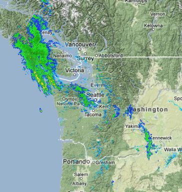
Here is a recent radar...you can see where the showers are:
The next issue will be the return of the northwesterly winds to Cle-Elum/Ellensburg. Take a look at the 4/3 km high resolution UW forecasts for tomorrow AM and tomorrow night. These are sustained winds..not gusts. The last figure is for 8 PM Sunday night...and the winds will be really cranking by then, with sustained winds of 20 knots in places.
This blog discusses current weather, weather prediction, climate issues, and current events
Subscribe to:
Post Comments (Atom)
Wind Uncertainty
T he confidence in weather forecasts is not always the same. Sometimes all the models lock onto a forecast, suggesting uncertainty is low an...
-
The latest model forecasts and the recent movement of the offshore low are now more threatening for snow reaching the lowlands of western Wa...
-
The model forecasts provided excellent over the past 24 hours, predicting the cooling and the localized snow in a Puget Sound convergence zo...


No comments:
Post a Comment
Please make sure your comments are civil. Name calling and personal attacks are not appropriate.