Downtown Ellensburg: Picture Courtesy of Stephers
Another picture by Stephers...but NOT a tornado. Rather a heavy rain shaft descending from a large convective system
Another picture by Stephers...but NOT a tornado. Rather a heavy rain shaft descending from a large convective system
And for me there was a special touch: I flew over some of the storms on my way back from a meeting!
As I noted in my last blog, the air over the region has the potential for major thunderstorms activity if there is sufficient lift to initiate the action.
It started quite early, with a collection of severe thunderstorms passing over the Tri-Cities and moving northeastward. Here is a radar image at 9:08 AM: red is very heavy rain or hail.
About an hour later I flew just south of these storms on my way returning from Denver. My flight was at an unusually high altitude (40,000 ft) and it was clear that some of the thunderstorm tops getting very close to our flight level. Here is a picture from my vantage point:
But then the amazing happened, a continuous train of very strong thunderstorms started to develop along the eastern slopes of the Cascades and never stopped all day. Let me show you some samples at a few times. First, at 12:30 PM
A fascinating subtlety was that the radar showed a nice case of storm splitting northeast of Yakima. Here is the radar 45 minutes later...you see the two red areas of heavy precipitation?
2:29 PM
4 PM--still going
And here is one at 6:40 PM...it hasn't quit!
You see that bright red echo (very intense) just east of the Cascade crest northwest of Wenatchee? According to the radar it reached 31,000 ft and it was clearly visible here in Seattle. To prove this, I took a quick pic of it from Mathews Beach Park in north Seattle.
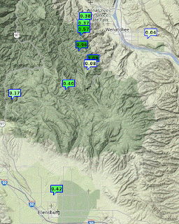
According the observed 12-h rainfall totals some observing locations received .5 to 1 inches of rain from these storms (see graphic)....but I am sure that much heavier amounts fell at places without rain gauges.
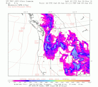
Thunderstorm activity was substantial on the east side Saturdaydue to the large amount of potential instability (high CAPE)--see graphic below-- and the lift of some weak disturbances approaching from the southwest. Furthermore, the mountains produce their own upward motion that can help initiate convection.
According to our computer models, tomorrow should be far drier, with very little thunderstorm activity.


.jpg)


An other blogger just wrote about her busy week drying cherry orchards around Wenachee with her helicopter. It hasn't been very good weather for the cherry growers, hopefully today's storms aren't causing them to loose too much crop. I suspect I'll be seeing more split cherries at the LFP farmers market in the morning.
ReplyDeleteI'm that pilot Unknown referred to. We got a ton of rain at my base about halfway up Squilchuck Canyon in Wenatchee. I haven't experienced rain that hard in many years. Your map indicates over an inch nearby; I believe it!
ReplyDeleteCliff what do you think about potential thunderstorms tomorrow evening? There appears to be a substantial area of rainfall centered in the Olympics around 5 PM according to the 3hr precipitation NAM. Also, quite a bit of cape around. I live in Sequim and am hoping for some entertainment.
ReplyDeleteColder air remaining from the receding trough, together with from off of the Pacific more generally, having apparently offset both the main stream of moisture from more out over the Pacific together with that more tropical from more directly south, even remnants of TS Cosme, looks at if.
ReplyDeleteSaturday was beautiful here but I am sorry I missed the action on the East slopes. I had a friend who was at Stuart Lake, he had quite a show.
ReplyDeleteAny chance you can take a guess at the long weekend? I'm wondering if it will be awesome or just a yawn on the WA coast.
ReplyDeleteThanks
I was camping east of the mountains Friday, Saturday and Sunday, just north of Dry Falls State Park. I heard distant thunder all night long Friday night. Saturday I could see a parade of storms passing me both to the west and east. Not a drop of rain fell were I was. But it was suspenseful.
ReplyDelete