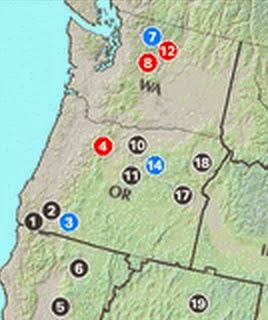
Eastern Oregon, which has been hit by a lot more lighting than eastern WA has far more fires (more than 2 dozen) going at this time. The U.S. Forest Service Major Incidents map tells the story (see graphic below)
But the situation is getting worse as temperatures rise and relative humidities drop east of the Cascade crest. And to top it off, the amount of convection and lighting are about to substantially increase.
Let's begin by looking at the relative humidities at Wenatchee, on the eastern slopes of the Cascades.
You will notice they are progressing downward, with the minimum today dropping under 10%. Relative humidity changes during the day, being the lowest when the temperatures are warmest. The temperatures at Wenatchee have been over 100F for four days.
Warm temperatures and low humidities are further drying the surface and vegetation--the "fuel" of future fires. The Forest Service 10-h fuel moisture shows how dry things are in eastern Washington and Oregon today. The dark red/brown ins the worst...right over eastern WA.
So the surface is ready to burn and the potential for new fires has increased the past few days due to the drying conditions. And, of course, there are several dozen fires already burning east of the Cascade crest.
But now we have another problem: the amount of thunderstorm and lightning activity is about to increase big-time over Washington.
The signs were starting to be evident today as some thunderstorm were initiated on the southern Oregon Cascades and drifted eastward. The radar image at 5:30 PM showed several of them:
And here is the 1-h lightning strikes starting at 5:30 PM
Unfortunately, the models indicate that the thunderstorms will become far more prevalent over the next few days. Let me shown you some examples from the UW WRF system. The following figures shows the 24-h rainfall ending 5 AM on Saturday and Sunday.
For the 24 ending Saturday morning (most of the showers would be Friday afternoon and evening), there are lots of showers over the central and north Cascades, and some in northern Oregon.
The next 24h indicates a major uptick in showers (including thunderstorms), particularly in the north Cascades and Okanagon.
The enhanced showers are associated with a combination of increasingly unstable air and the upward motion associated with a weak trough moving into the region, as illustrated by an upper level (500 hPa) chart at 11 AM Saturday.
So we have the fuel (dry trees, bushes, grasses) and the ignitor (lightning). There is a good chance of more fire starts, particularly over Washington. And the large upper ridge is staying in place...so the fire risk is not going away soon. Our regional wildland firefighters, already tired from restraining the last round of major fires, may be faced with an even more onerous task. You really have to respect what they do.


Cliff,
ReplyDeleteA couple positives are that the biggest fire to occur in Oregon from these thunderstorms starting Monday was 3/4 of an acre big. Another positive is that there is some shower activity involved with these storms to help dampen the fuel. In fact, on Tuesday Sisters, OR received around an inch of rain from a thunderstorm that came through their area. The job of a meteorologist is of course to evaluate the risks but the job of a resident living in the meteorologist's CWA is to decide how to interpret the risk.
Here is a link to photos from this morning. All were taken near Battle Ground, looking west.
ReplyDeletehttp://weathercrazy.smugmug.com/Weather/Lightning-Display-8114
This year has obviously been unusual for the number of times batches of thunderstorms have moved into the area (especially Oregon). We've also had significant lightning caused fires the preceding two years. As a kid I recall having lightning storms in the NW being an unusual occurrence. Is there any evidence to indicate that lightning activity has increased here and if so, does it relate to climate change?
ReplyDeleteVery loud electric storm in the Maple Leaf neighborhood of Seattle at 11am today. A friend of mine reported a lightning strike there.
ReplyDelete