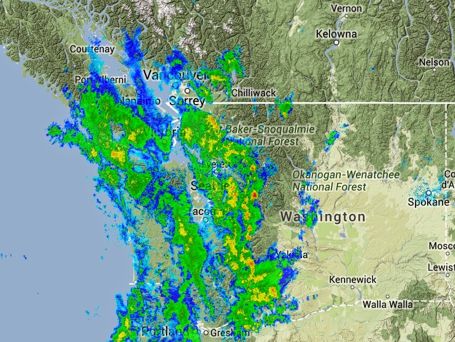
8 AM update
Lots of heavy showers and thunderstorms moving through here is the latest radar. Yellow are heavy showers....and there are even some reds (downpours or hail) in a few cells.
and the lightning during the half-hour ending 7 AM in shown below. Not much lighting in easternWA yet. Lots on the eastern side of Puget Sound.
*We are now entering the climatologically driest period of the year, with the last week of July/first week of August being the most arid of the year. July is usually our driest month, and this year has been drier than most (only a trace of rain so far at Sea-Tac airport).
But everything changes tomorrow, when a July deluge is forecast by our weather forecasting models.
Just to impress you. Here is the 48h total precipitation predictions to occur starting 5 PM Tuesday and ending 5 PM Thursday. Wow. The western slopes and crest of the Cascades get hammered, with totals of 1-3 inches. Even the western lowlands get quite wet, with modest amounts extending into eastern Washington. Not a good time for hiking or camping in the Cascades.
This heavy rain is associated with the approach of a sharp upper-level trough/low (see upper-level map for 5 PM on Wednesday.) Pretty impressive this time of the year.
This air is potentially unstable and there could well be some embedded thunderstorms.
The rain should start moving in around 8 AM
Strengthen and move northward during the day
Transition to showers as the low passes by on Wed. night
And then we get more rain on the backside of the low on Thursday AM
I am worried about eastern Washington getting light rain, including some thunderstorms--with the potential for more lightning induced fires. And there is the potential for strong winds over both western and eastern Washington as the trough/low move through.
I expect several local stations to exceed their daily records if the models are right.
This blog discusses current weather, weather prediction, climate issues, and current events
Subscribe to:
Post Comments (Atom)
A Very Strong Cold Front Will Cross the Northwest on Tuesday
The Northwest is known for its weak cold fronts, since the relatively warm Pacific Ocean warms, near-surface, cold Arctic air before it arri...

-
Today may be the last day you will need air conditioning this summer in western Washington. And fears of wildfires west of the Cascade cres...
-
Over the eastern U.S., the passage of a strong cold front, with a rapid decline of surface temperature, is a frequent winter treat. In contr...


.gif)


Started seeing lightning flashes and hearing thunder a bit after 5:00am in the Sumner area. I might not have noticed, but it freaked out the dogs which meant sleep was over!
ReplyDeleteI was in eastern Oklahoma City 2 weeks ago when just under 4 inches of rain fell in a short time during the night. Thunder and so much lightening it was like a bunch of strobe lights. Fascinating to watch.
ReplyDeleteJust heard thunder in Kirkland! That is rare in general and especially this time of year.
ReplyDeleteGot really dumped on by a heavy thundershower around 6AM here on Bainbridge Island. Lots of rain but only a handful of thunderclaps.
ReplyDeleteHey Cliff,
ReplyDeleteI sit in an office with floor to ceiling windows downtown and normally we sit with the lights off, even in the dreary winter because we get enough natural light through the clouds... but today seems extra dark. Its 11:45am, but it feels like the sun should set at any time. Why does today seem so much darker than the winter rain storms?
Thank you, Cliff. I enjoy your explanations, forecasts, and updates.
ReplyDeleteNo doubt about it, this July rain event is a bit unusual. I hope it does not bring wide spread "late-blight" to the tomato crop that has been doing so spectacularly this year.