We can be proud (I guess) that the Northwest has some of the worst air quality in the nation--or so says the U.S. government's AirNow website:
And, in fact, Puget Sound Clean Air Agency has burn bans on right now in Snohomish and Pierce counties.
The region, strangely enough, is the push of warm air aloft. The warming has been profound aloft during the past 48h, with the air warming 15-25F in layer starting a few thousand feet above the surface. At Paradise on Mt. Rainier (5500ft) it has become nearly spring-like, with temps reaching near 50F.
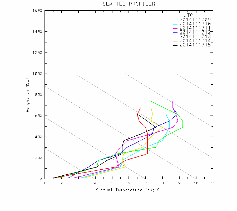
With warming aloft, with cooler air stubbornly holding in at the surface, we have seen the development of a strong inversion (temp increasing with height). To illustrate, here is the lower atmosphere temperature soundings on Monday morning from 1 AM to 8 AM. Temperature increased 8C (14.5F) in 500 meters (roughly 1600 ft) during that time period.
Inversions are very stable layers and tend to trap pollution near the surface. Here are the particulate observations (PM2.5) for the last week for Seattle Duwamish, Tacoma, Lake Forest Park in N. Seattle, and Marysville in Snohomish County. The trend is clearly upwards.
You notice that there is a big daily variation in air quality. Better during the day and gets bad rapidly in the evening--worse around midnight.
A few things contribute to this diurnal (daily) variation. First, folks come home around dinner time and crank up the heat...which pushes combustion products into the air. Then around midnight the heat is turned off and air quality improves. You will see a smaller secondary peak around 6 AM when the heat comes back on for some. Another issue is meteorology. Sun during the day warms the earth and causes some mixing in the vertical (like in your cereal pot). This improves air quality. At night, with nocturnal surface cooling, the inversion strengthens and air quality degrades.
We will have to deal with degraded air quality for a few days...later this week, the storms, rain, and wind return.
This blog discusses current weather, weather prediction, climate issues, and current events
Subscribe to:
Post Comments (Atom)
Cold, Wet, and Snowy Period Ahead
Get your umbrella handy, find those wool mittens, and look for your skis.....an extended period of cool, wet weather is ahead. Let's st...

-
In act one of this meteorological drama, yesterday and this morning brought heavy rain and flooding to many sections of western Washington. ...
-
The heavy rainfall is over, but some rivers are still rising. The most impactful atmospheric river event of the past few decades. Consider...


Could you consider adding links below the images that you use in your blogs which direct to the source website?
ReplyDeleteCliff- As someone who frequently goes to China and as a former air regulator myself, I have to chuckle a bit about this post. I live in Pierce County. The burn ban notice is based upon data from the monitor that is recording the highest concentrations of pollutants. This is done to be protective of everyone, including the most sensitive individuals, who often suffer from asthma or who have other lung-related ailments.
ReplyDeleteOften, the burn ban notice for Pierce County is based on a monitor in south Tacoma (around south 84th street). This area has a high concentration of people who rely on wood to heat their homes (you can see these data from Puget Sound Clean Air Agency or WA Department of Ecology reports).
Yesterday, despite the impaired air quality, I was still able to clearly see Mount Rainier.
The Chinese would die (perhaps literally) to have air quality as "impaired" as ours. We should count our blessings and be thankful that we have air quality standards that are consistent with the latest science and public health information, and that the local air quality agency is pro-active in providing notice to the public.
Just hunkerin' down waiting for a cold front to break up the inversion, clean up the air and warm it up.
ReplyDeleteCliff what's wrong with the air quality folks? It makes no sense to me that Snohomish and Pierce Counties have burn bans but not King County! There are so many more sources of pollution in King county, since it is so much more urbanized... and has more vehicles.
ReplyDeleteThis is not the first time: I have seen this before. Sounds like someone is playing favorites. I can't imagine that the air flow patterns would flush out King but not the two bordering counties!
Ansel- While you are right that King County has more sources of air pollution than Pierce and Snohomish, you have to look at the particular pollutant that is causing the problem. In this case it is fine particulate matter. Since a big source of that is people burning wood or wood products to heat their homes, it is a bigger problem in Pierce and Snohomish where that is more common. Of course there may be other factors such as Targhee brought up (placement of the sensor,) but that is the basic reason why this had a greater regulatory response in Pierce and Snohomish.
ReplyDeleteAnsel - seconding what Eric B said, but also adding that King County does generally get more winds when there is higher pressure in Eastern Washington as the offshore flow is strong when the pressure gradient is so sharp, and the winds pour over the shortest mountain passes (in King County) toward the water. Meanwhile pockets like Tacoma and Pierce County lie are protected from winds thanks to Mt. Rainier.
ReplyDeleteWhy do we not call our seasonal rains by descriptive title like "Monsoon"? Are we just uncreative? Shouldn't OUR rain have a name or names?
ReplyDelete