As shown below, the western U.S. has been slightly drier than normal during the past two weeks, but we generally don't get much during this period anyway.
But let's look at the latest precipitation forecasts from the UW WRF model. Each is for a 24 hour period.
Except for the coast, most of the region is dry through 5 AM Wednesday.
But then, we get hit by the first system, with moderate precipitation west of the Cascades crest, particularly over the windward slopes (24-h total ending 5 AM Thursday)
Even more during the next 24 hr (ending 5 AM Friday), with eastern WA getting a piece of it.
And more showers on Friday:
And showers on Saturday
Only the 24 hr ending 5 AM Monday brings a respite for western WA and Oregon
Looking at a different model (the National Weather Service GFS), the 6 day total shows light to moderate precipitation over the NW, with heavier amounts in BC. Rain seems to be avoiding California, ending abruptly at the northern and eastern borders. I will let you speculate about the water-repellant nature of that state.
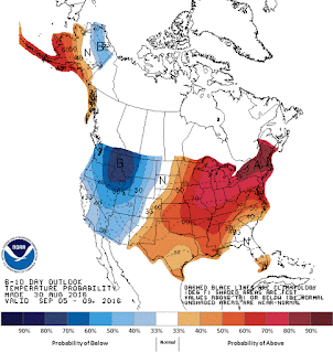
The eastern part of the country will be toast as a result. The 6-10 day temperature anomaly forecast by the Climate Prediction Center shows cooler than normal over the West, but above-normal temps over the East.
Announcement: Climate Surprise Talk
During the evening of September 28, I will be giving a talk in Seattle at UW's Kane Hall on Climate Surprise: Unexpected Impacts of Global Warming on the Pacific Northwest. This will be a new talk, based on the latest research, that will describe some regional "climate surprises" that may well occur in our region during the next century. This talk is sponsored by CarbonWa and the Audubon Society To find out more or to secure tickets, please go here.


Cliff,
ReplyDeleteWhat's the best online site to see observed precipitation totals for washington state, ideally with pretty detailed spatial resolution? I would like to be able to look back day by day over 4 hr to 24 hr periods to see how much rain fell using a map format. For example, CA has the wonderful CNFRC sites, is there anything like these data for WA?
http://www.cnrfc.noaa.gov/precipMaps.php?group=nca&hour=24&synoptic=0
Thanks,
Ed
Why does everyone around here think Fall starts in late August?
ReplyDeleteI'm lpoking forward to some rain - that means I'll have Burke Gilman largely to myself when I go for a walk...
ReplyDeleteWe are so pessimistic about our summers that we're basically ready to declare Fall's arrival as soon as the weather turns. Granted, when the weather turns in the northwest it usually stays for awhile, we don't really have those wild daily shifts, so it's understandable.
ReplyDeleteThe cold and wet doesn't really feel like it's come until October when things dramatically change, but you can definitely feel some hints late Sept. I think.
So true. I'm one of those people. We would do well to remember that we had cool, wet weather in July. My July 4 barbecue was miserable because it was so cold and breezy in the evening. The more I live here the more I think summer ends on Aug. 1.
DeleteIt's not fall on the calendar for another three weeks. Cliff must be talking climatological fall?
ReplyDelete