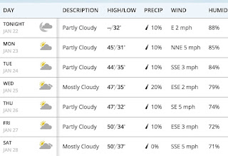
From Monday through Thursday, the annual meeting of the American Meteorological Society will take place in Seattle and they will enjoy nearly perfect weather. Dry and temperatures reaching the upper 40s F each day.
It is fortunate that the meeting wasn't in San Francisco, Los Angeles, or California...locations that will continue to experience rain, wind, and mountain snows.
The infrared satellite image on Sunday night tells the story (below), with a deep low pressure area (swirling clouds) off of Oregon. Cold instability showers are circling around into California. During the next few days the low center will move southward, leaving a ridge of high pressure over our region. Dry and relatively warm conditions will dominate.
Here is the upper level weather map for Thursday morning. The ridge is evident, as is the trough of lower pressure over the hapless folks in California.
The precipitation forecast for the next 72hr indicates nothing over most of WA state, but substantial precipitation over northern CA.
And the forecasts provided by weather.com for Seattle indicate only a slight change of precipitation and temperatures reaching near 50F by the end of the week. Add this weather to the later sunsets (after 5 PM!), will make it seem springlike in the city.
With warmer temperatures and dry conditions, little new snow is expected in the mountains. There were a few inches of snow during the past 24h, which helps covers the ice layer produced by freezing rain this week in the lower passes.


Look, I'm no meteorologist but I fear that perpetual stratus will take over the area and air quality will worsen. And the still low sun angle won't help to break it up. Nearly perfect weather and ridge of high pressure you say but no mention of sun. Yikes! Am I getting seasonal affective disorder??
ReplyDeleteFantastic! Wishing all attendees a magnificent convention with spare time to take in the beauty of our mountains, budding trees and waters.
ReplyDeleteWhen does the moisture return? We need more snow in the mountains and this warm up is not helping keep the snowpack.
ReplyDeleteJust in time for release of the first preliminary images from the new GOES-16 satellite . The new imager is amazing, especially compared to the older imagers.
ReplyDeleteRicky Poole: "We need more snow in the mountains and this warm up is not helping keep the snowpack."
ReplyDeleteYesterday was 2 degrees below average at SeaTac in a month that has been substantially below average.
Here is the current snowpack: www.wcc.nrcs.usda.gov/ftpref/data/water/wcs/gis/maps/wa_swepctnormal_update.pdf
90%+ in the Cascades, 117% in the Olympics (actually an increase from a few days ago when I made a similar post to an equally alarmist comment.) Can you please 1) back up the claim that “we need more snow in the mountains” (with historical statistics vs. actuals) and 2) support with evidence your claim that "this warm-up is not helping keep the snowpack"?
And since you won't be able to, can I ask: why do you make these comments?
Spot on response.
DeleteAny thoughts Cliff on why we keep hitting 2+ week periods of snow droughts in the BC interior? I thought with La Nina, the blob dead and the arctic outflow retreating we would return to a more standard weather pattern with the pacific flow... In Revelstoke they were forecasting near 90cm last week, we got around 30 and it looks like we're in another 2 week snow drought but with somewhat milder weather as all the precipitation goes south? and maybe north? In Revelstoke looks like in terms of historic averages we are going to be at around 25% accumulation for an average January. (50cm) The Rocky Mountain resorts here haven't seen much since October.
ReplyDeleteDarn good thing they didn't bring Al Gore with them.
ReplyDeleteAnybody see the Badlands National Park tweeting today on climate change?
ReplyDeleteThis child/TRMP, just deleted all the tweets, changed the WhiteHouse.gov site, which now reads..."We must take advantage of the estimated $50 trillion in untapped shale, oil, and natural gas reserves, especially those on federal lands that the American people own. We will use the revenues from energy production to rebuild our roads, schools, bridges and public infrastructure. Less expensive energy will be a big boost to American agriculture, as well."
The official site for yourself...https://www.whitehouse.gov/america-first-energy
Sounds like the exploitation of the planet to me.
Dr. John Barentine has the scoop on the tweets:
http://www.vox.com/2017/1/24/14376954/badlands-national-park-climate-tweets
Sounds like "He" is trying to control our whole society and freedom of speech, including our climate and anyone speaking on it. Before long, this blog will be banned. So the Badlands National Park can't tweet, but he can, right? Of course. Really...
EPA on lockdown. NO JOKE!
Uhh....
Terry McDonald: "In Revelstoke looks like in terms of historic averages we are going to be at around 25% accumulation for an average January. (50cm) The Rocky Mountain resorts here haven't seen much since October."
ReplyDeleteI live in Seattle so am not on the cutting edge of snowfall in Revelstoke, but I did look up the Revelstoke ski area historical snowfall information. It is here - http://www.revelstokemountainresort.com/conditions/historical-snowfall
It is currently running at the 10-year high. As in this year has more accumulated snowfall (746 cm) through this date than any year in the last 10 years. Since October they have added about 500 cm (16 feet).
I am not understanding what you are saying.
Hey Dr. Mass,
ReplyDeleteI saw a radar image of birds scattering (Rachel Maddow show--MSMBC) in Oklahoma after they sensed an earthquake immanent. There is greater incidence of earthquakes in Oklahoma due to oil fracking.
Cheers,
Bert