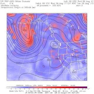
But as we will see, there are some dangers to this change, including pole fires, power outages, more wildfires, and slippery roads.
During the past week, a ridge of high pressure has dominated the flow over our region, as shown by this upper level chart for Tuesday at 5 PM. It has been a very stable pattern, resulting in warm conditions and light winds. The smoke settled in over our region.
But the models are emphatic that the ridge will move inland, and a Pacific trough will approch us. The forecast map for Saturday at 5 PM shows you what I mean.
Today (Friday) will be the last warm day before the change, with temperatures rising into the lower 80s.
But Saturday will be a different story, with increasing clouds and wind from the approaching disturbance. The smoke will be pushed eastward. And even some light showers are possible. The major rain will wait until Saturday night and Sunday morning.
Here are the 24-h total precipitation forecasts for next few days. For the 24 h ending 5 PM Saturday, light showers over western WA and what looks like some convective (thunderstorm) precipitation over eastern Oregon. It is good the eclipse is not tomorrow!
But the next 24 hr (ending 5 PM Sunday) is much wetter over western WA and the coast. No much by winter standards, but the most we have seen for months (roughly .1 inches over the interior and .5 inches along the coast)
Now what are the potential downsides to this change of weather?
1. Slippery roads. The first rain of the late summer falls on roads that have accumulated oil, dust, and other particles, often producing a transient slippery surface. So drive carefully when the rain starts.
2. Pole fires and power outages. According to a retired City Light employee I have worked with, the dust and muck deposited on wooden power poles can become conductive with a little rain, causing short-circuits, fires, and power outages. The long period without rain this summer makes us particularly vulnerable.
3. Lightning. The approaching trough can initiate thunderstorms that could start new wildfires over the Cascades and eastern WA/Oregon. And yes, perhaps endangering a few golfers.
I suspect most of you will be happy with the return of normal weather.
Many are starting to think about the eclipse. Well, the latest upper level (500 hPa) forecast from the National Weather Service GFS model for 11 AM Monday morning (21 August) shows a trough, with clouds and showers, over the region...not good! But don't worry.... the skill at 10-11 days is very poor.


The rain can come in as quickly as it wants...soooo need it. Smoke has been really hard on my lungs, as an asthmatic, and I'm so tired of the heat and sun. IOW: YES! We get our rains back! :)
ReplyDeleteI'll take the danger, just give me cooler air and rain.
ReplyDeleteIs there any worry that the North winds will return next week bringing the smoke back in on Monday and a Tuesday?
ReplyDeleteI live on 20-acres, which back up to a 1,000 acres of undeveloped land above the South Shore of Lake Chelan. My irrigation line was broken in last winters Spring run off and I am dependent upon 1 spigot of domestic water for all my fire protection and I live just below the Bear Mountain Ranch Golf Course. So, your golf course comment hit me like a slug to the tummy.
ReplyDeleteCliff, I hope you will tell us as time gets near whether Madras or Salem will be better for clear skies. (I paid for reservations in Madras). Thanks
ReplyDeleteHi, this is from the NWS website.
ReplyDeletehttps://www.weather.gov/source/crh/eclipse.html
Forecasts for the eclipse will be available for each location along the path by August 15th (7-day forecast)
We have RAIN in northeastern Seattle!
ReplyDeleteHi Cliff - national media says the last two weeks are evidence of global warming: debunk? or are they right? https://www.washingtonpost.com/news/powerpost/paloma/daily-202/2017/08/14/daily-202-evidence-of-climate-change-abounds-amid-extreme-weather-in-the-pacific-northwest/59910b8e30fb0462b8e1a9c4/
ReplyDeleteJay, you can look at past postings on this very subject, there have been too many to count over the past few years. Either stick to the subject at hand and/or try harder next time.
ReplyDelete