Picture courtesy of Dr. Angela Rowe
A view from the Seattle Space Needle PanoCan shows the cap cloud AND a lenticular cloud downwind.
You want to see the mother of all cap clouds? Here is an example.
Why do cap clouds form? When moist air is forced to rise by a mountain, the air cools and eventually saturates--producing a cloud; when it sinks on the lee side, the cloud evaporates.

Cap clouds are generally a sign of changing weather--an indication that moist air is approach a mountain (in this case Rainier), usually accompanied by a strengthening of the winds aloft.
When a storm or front approaches the region, often the first sign is a cap cloud over Rainier. For a closer look at today's cap cloud, here is a cam shot from near Rainier.
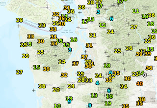
Here are the max winds for the past 24 hr ending 9 PM Friday. Some locations had gusts to 35-40 mph.
Why strong winds? The front produced an enhanced pressure gradient (change of pressure with distance) over the south Sound and south of the Olympics, with a trough in the lee of the Olympics contributing to the pressure gradient (see pressure forecast for 8 PM Friday below) That pressure difference accelerated the wind as air moved from high to lower pressure. Even some scattered power outages around the areas.
The latest infrared satellite imagery shows cold, unstable air behind the front, indicated by the popocorn-looking clouds over the eastern Pacific -so expect some showers tomorrow (see image)
In fact, the forecast 24-h precipitation total (ending 5 PM Saturday) shows impressive contrasts, with up to a few inches on the western side of the Cascades, but virtually nothing on the eastern side of the barrier. So if you want to be dry, head east. It will be beautiful, but windy on the eastern slopes of the Cascades.


They are the same John King. "Lenticular clouds, sometimes called "cap clouds," form over mountain peaks when moisture begins to increase in the upper levels of the atmosphere." http://www.king5.com/mobile/article/weather/blog/what-is-a-lenticular-cloud/305104727
ReplyDeleteMy bike commute passes a great Rainier vista point. It's a good opportunity to just look at the atmosphere. Right now we are tilted toward days that have something to see, vs the majority where it is either all clear or all cloud. Fun time of year.
ReplyDeleteThis is the exact question this post addresses. Read it again slowly amd carefully.
ReplyDeleteAlso, why do you sometimes see cap clouds and lenticulars stacked like pancakes? What is the process that loosens the cap cloud to become a lenticular?
ReplyDeleteWikipedia say cap clouds (or pileus?) can form above other rising clouds, ash clouds: and mushroom clouds:
ReplyDeleteAre these the same thing or are cap clouds just limited to terrain objects?
FWIW, we had Lightning, thunder and quite a shower of hail in here in the hills of South Bellevue Saturday evening.
ReplyDelete(Belling)Hamster, here. I've heard the classic windstorm which impacts areas north of Everett called a "Southeast Sucker". Can you explain the origin of the easterly component which seems to be particular to and partially responsible for the high winds that often occur between Blaine and Everett during the wet season? P.S. I'm going to keep asking this question until I get an answer or I lose the ability to type.
ReplyDeleteThis has 2 be one of my favorite post! I continue to wait for the next lenticular outbreak or super outbreak my collection of the dance continues to grow! http://bit.ly/2y6YLpf look forward to future cloud chasong!
ReplyDelete