Sunday morning we had the classic snow/cold upper level pattern, with a ridge of high pressure offshore and a tight trough over the Northwest.
But this will change substantially this week, with a deep trough building offshore. This will keep us cool (highs in the 40s), with a lot of moisture coming up from the southwest. California and Oregon will get hit particularly hard.
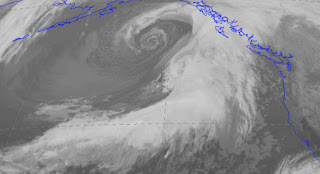
You can tell the atmosphere means business by viewing the latest infrared satellite picture. A huge swath of clouds ready and eager to move into the West Coast.
You can not expect much relief from the cold and wet for a long time. The best way to look forward is to examine the forecasts from a large ensemble system. Here is the NAEFS ensemble almost to Thanksgiving at Seattle. The whiskers show the range of the forecasts and the most probable value by the horizontal line in the yellow boxes. 50% of the forecasts are contained in the yellow boxes. Temperatures rising to roughly 6C (43F). Rain most days. Cloudy for nearly the entire period. The kind of weather that should make Amazon yearn for a second HQ in a warm, sunny place.
My rule of thumb for mountain snows in fall is that when Seattle is less than 50F there will be snow at Stevens pass and above. Looks good. I suspect a number of ski areas will open next week...all they need are a few more storms.


HI Cliff! I'm up Canada and am fascinated reading your weather blogs. This forecast looks more favorable for precip deeper into central BC compared the last system. Can you give your thoughts? In Revelstoke we typically get our biggest snow systems that come from the west or south west. Not as much as the south (which typically favors the Okanagan and Kootenays) or the north (which typically favors the Purcells and Rockies) The last system seems to move down very quickly from the north west, then up from the south the following day, giving quite a bit of snow to everywhere but Revelstoke (Kicking Horse 90 minutes east got 92cm in 48 hours while we got about 10cm)
ReplyDeleteIt had been pretty warm, n wet, and now very cold and dry with an arctic ridge pushing everything to the south. Any idea what can we expect moving forward from now to the middle of November and where the stormtrack might favor? As it stands we'll need a fair bit more snow before many ski resorts can open!
I'm glad to see Northern California is getting in on this.
ReplyDeleteOuch (5 inches plus) in the mountains. I suspected as much and went for a 4 mile run along the Padilla Bay Shoreline Trail around 4pm. Early sunset was beautiful, maybe 10 degrees cooler than last Monday. I half expected to be alone, but no, other runners, dog walkers and families with tiny tots and kids on bikes were out there too. Perhaps we all sensed biblical style rains arrive soon. Cliffs weather forecast a case in point.
ReplyDeleteHasn't been all that cold down here in the Willamette Valley. Looks like the persistent pattern will be for cold/snow events to affect Washington more than Oregon as opposed to last winter. Will be surprised to see us drop below freezing here much as we will be in the warm sector of most of these events.
ReplyDeleteI jumped over to your site after reviewing the Venure forecast for mid-Canadian and mid-west, to east coast (NYC, PHL, DC) areas. On this map: https://www.vencoreweather.com/blog/2017/11/7/1220-pm-late-week-arctic-blast-may-not-be-the-last-of-the-monthhigh-latitude-blocking-pattern-likely-to-form-by-thanksgiving. It looks as if this huge "block" back east may have some effects on our region. Can anyone, Dr. Cliff included, assist with this?
ReplyDeleteThanks,
Mathbrown73
Ahh, westerly flow next week. The snow machine is going to rev-up! The GFS shows FEET of snow between Monday and Thanksgiving with very few breaks in the troughs and short-wave features embedded within. Great blog, Cliff. We will be skiing by Thanksgiving, if not by early next week (Crystal). The active pattern appears to hold through the entire month of November. Viva La Nina!
ReplyDeleteMan, after the long dry spell in these parts, I say, bring it on! People don't seem to realize that even with this kind of weather, you can still do a lot of outdoor activity that you could never attempt to do in many other areas of the country at this time of year.
ReplyDeleteLooking at the latest weather maps it looks like most of the energy is going south of us. The systems are not well developed at all, at least not until Sunday when we may get a better shot of rain. Today was dry and calm - a beautiful fall day.
ReplyDeleteThe rain, coming as it was from the south, created a huge rainshadow over NE Oly Pen and out into the San Juans and eastward. Some years (depends on the direction the prevailing weather is coming from) the rain shadow effect is way more dramatic than other years. So far, this is shaping up as a good year for the shadow.
ReplyDeleteOver the last 48 hours, we got exactly 0.01" at my house near Sequim. The rain kept wrapping around us, coming within a few miles as it flowed up either side of the Olympics, but couldn't quite handle the downslope conditions and warming.
We even had a couple of hours or so of sun in mid-morning today (Thurs) as this big blue hole opened up to the SE of us. Time to sit on the deck and soak up the Vitamin D. Even my Labs, who have been playing in the snow since the weekend, just wanted to lay in the bright sun and sleep today. A dog's life!