Foggy Sunrise Over Seattle
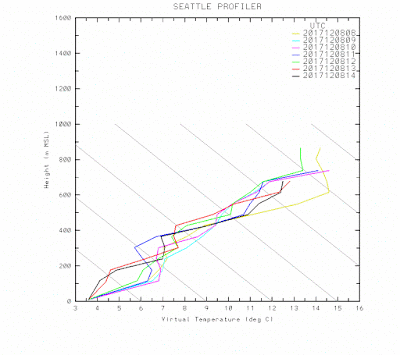
With high pressure in place, skies are relatively clear aloft allowing good radiational cooling to space from the surface. At the same time, temperatures aloft have warmed. The result is a super inversion, with temperature increasing rapidly with height. Here are the latest temperatures above Seattle from the radar-wind profiler at Sand Point. An increase of 12C (22F!) in 800 meters (2600 ft)
Here are the 7 AM observations around the region. Lots of fog and air temperature at and below freezing at many locations. And remember these temperatures are taken at 2 meters above the surface--the surface is colder!
Really dangerous, so be careful. The street in front of my house is all glazed up...I will have to be extremely careful in my bike in to work. Fog is more extensive this AM because the offshore flow has weakened, something shown by the time-height cross section for the observations above Seattle-Tacoma Airport (red temps, blue winds, height in pressure...850 being about 5000 ft, time increasing to the left).
Why is fog and subfreezing temperatures so dangerous? Because fog has a lot of water content and can freeze rapidly on roadway surfaces. So, an image like this spells DANGER on a cold morning.
And in this one, you can SEE the ice on the roadway!
Some folks have reported strange sound effects with the strong temperature inversion, hearing boat horns many miles away.


Yeah, this inversion is impressive. It is 24F at my house by Lake Sammamish now. It actually hit 67F yesterday at Paradise and is currently hovering around 50F for most locations above 5000 feet; that's 26 degrees warmer a mile above the lowlands!
ReplyDeleteUnder what circumstances does radiational cooling overtake the warming of downslope air, and vice versa? We have this offshore flow of very mild air that's making the coast beautifully warm, but the valleys are cooling below freezing at the same time. Why do some low lying areas on western slopes cool off and others warm?
ReplyDelete- James H
It was interesting in Shoreline, where skies were clear. On the warmer mornings, the frost was worse. Today (Friday) was colder and the frost wasn't as bad. Rode all the way down to UW with ease.
ReplyDeleteI concur with Cliff about the bike situation. I was walking mine down a hill early last week at 6am and slipped landing on top of it hurting my leg and several fingers. Had to crawl of the road dragging the bike to keep it from sliding down the hill. Now I walk down in the grass next to it. A thick layer of frost or black ice is very slippery.
ReplyDeleteCliff, re "you can SEE the ice on the roadway", IMHO you are seeing the salt brine which SDOT or other transportation agency has applied. I've ridden on Lake Washington Blvd the morning after a predicted freeze, and the roadway appears wet, but it soon (!) becomes obvious it's not ice.
ReplyDeleteCliff, are we going to have any snow this year? This winter seems so dry. Thanks.
ReplyDelete