The first week of the New Year promises dry conditions, no snow, no storms and moderating temperatures.
The reason? The return of high pressure (also known as ridging) over the the West Coast.
The temperatures at Seattle during the last 3 months has had a number of swings, but overall it was a very normal fall/early winter. Note that the number of negative excursions roughly equal the positive ones--a sign of normal conditions for the period.
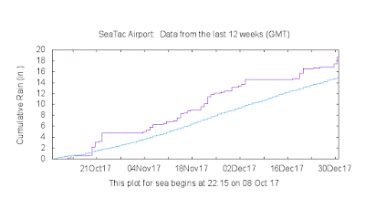
The cumulative precipitation at Seattle was wetter than normal (19 inches fell when normal was 15 inches). Above normal, but not that anomalous.
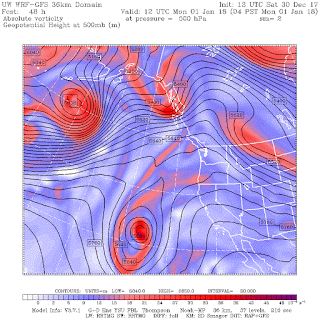
The spigot will be turned off during the next week, with high pressure producing sinking air that dries out the lower atmosphere. The upper level (500 hPa) chart for Sunday at 4 AM shows the ridge in place.
Monday morning, the ridge is still there over the Northwesr, but with an moderate trough moving into SE Alaska.
Tuesday morning....the West Coast ridge strengthens!
But later in the week (4 PM Wednesday shown), while the ridge holds over the Northwest, a trough (with precipitation) reaches California....they can use the moisture.
Happy New Year....


Hi Cliff,
ReplyDeleteI just listened to your latest "Weather with Cliff Mass" on KNKX about inversions. I live on the North Oregon Coast, and we often have clear skies and warmer temperatures when the Willamette Valley, Puget Sound, and other inland locations have freezing fog during a late fall or winter inversion.
I understand that with an inversion temperatures increase with height, and you can often find clear skies by traveling a few hundred or thousand feet up the foothills or Cascades. But why is the coast often clear during an inversion inland? Is it due to the relatively warm Pacific Ocean?
I look forward to hearing your insight. Thanks again for the great blog!
Ryan
Interesting article on how scientists determine the contribution of climate change to extreme weather events.
ReplyDeletePuffin....a lot of problems with that articles...much of what is stated is not supported by the science..cliff
ReplyDeleteThis comment has been removed by the author.
ReplyDeleteThe warm rains a little while back coupled with the dreary high pressure periods have really combined to decimate the Oregon Cascade snow packs as well as the snow cover in Eastern Oregon. According to NOAA the La Nina indicators are still evident. I hope the usual correlations start showing soon or we are in for trouble.
ReplyDeleteMost articles have some problems in them. Rather than making a blanket statement about the NY Times article could you point out what science you feel they got wrong and why you feel it is wrong?
ReplyDeleteCliff. Still curious to see a post on what global warming influenced weather would look like to you. This confusion of climate and weather, and scientists downplaying extreme weather events as being influenced by global warming, tends to serve the deniers. So what sort of weather events or short term (noticeable to normal people) weather conditions would lead you to say, yeah, “that is global warming”?
ReplyDeleteSeems as good a time as any to thank you Cliff for your blog and as importantly the opportunity to comment. The fact you have - for years now - had the cojones to speak the truth in this political climate (chose that word on purpose) makes you special indeed. Providing a forum for dialogue makes it that much better. Hats off to you and Happy New Year!
ReplyDeleteJohn Franklin:
ReplyDeleteSee if you can find any graph resembling the "Higher seas along the gulf coast" graph in the article. Suggest you start with the Galveston tide gauge graph from NOAA:
https://tidesandcurrents.noaa.gov/sltrends/sltrends_station.shtml?stnid=8771450
Do you see a sudden upturn to 9" (228.6 mm) above "normal?"
A GPS unit at Galveston showed the coast to be sinking 4.6 mm/year from 1995 to 2003. Subtract subsidence from the +6.5 mm/year relative sea level trend and you'd get a graph similar to that for Pensacola FL over the last 93 years:
https://tidesandcurrents.noaa.gov/sltrends/sltrends_station.shtml?stnid=8729840
A GPS near Pensacola also shows a bit of subsidence. Subtract that and you get +2 mm/year.
What are "normal" tropical Atlantic SST and atmospheric water vapor over the last hundred years?
The author and his cohorts claim to "know" that increased atmospheric CO2 has made extreme weather events more extreme, but using exaggerated graphical contrivances suggests a lack of confidence in their "proof."
Cliff, I am interested in your opinion on this study by climate modelers at Lawrence Livermore National Laboratory:
ReplyDeleteClimate scientists see alarming new threat to California
The study indicates that reduced Arctic sea ice greatly enhances the formation of long-lasting high pressure ridges off the US west coast, especially California.
I would very much like your opinion on the science here, as you have frequently expressed skepticism here in your blog about a connection between global warming and Pacific high pressure ridging.
Jeez it sure would be nice to see a classic pacific winter storm cycle rather then 2 days of precipitation then pretty much nothing for 10 days. All our snow this month came over like 5-6 days in large amounts with little or nothing in between.
ReplyDeleteHappy New Year!
ReplyDeleteI wanted to take a moment to tell you how much I enjoy your blog. I was a weather briefer for an airline years ago, but was no expert by any stretch of the imagination.
The weather in Western Washington always puzzled me...especially whenI moved from Dallas to San Juan Island nearly 30 years ago. Your blog has taught, and continues to teach me, so much! . So thank you for the education, your clarity and also for the interesting comments you garner...they can be enlightening too!
Wow... this ridging certain seems to be a common pattern the last few years. I wonder what you think of this recent research tying a warming arctic to these "remarkably resilient ridges"?
ReplyDelete<a href="https://phys.org/news/2016-10-extreme-cold-winters-fuelled-jet.html>Extreme cold winters fuelled by jet stream and climate change</a>