This morning dawned clear and cold, in fact, one of the coldest mornings so far this fall. Temperatures ranged from mid to upper 30sF near the Sound to low 20s away from the water. But travel east of the Cascade crest, and lots of locations dropped into the lower teens, even single digits in low/cold spots. This cold is allowing Mission Ridge and Crystal Mountain to make snow and open.
Some frost around the region, but little fog. Why? The air is simply too dry.
There will be no precipitation today and Saturday. But Sunday, a low pressure system will be approaching from the southwest, spreading clouds and precipitation into the region.
To illustrate, here is the predicted surface chart for 1 PM Sunday, including sea level pressure (solid, lines), surface winds, and low-level temperatures (color shading). You can clearly see the low pressure center offshore and it you look closely, you can see southerly winds and warmer air pushing northward to its east. In fact, there is a weak warm front pushing northward along the WA coast. Easterly winds are over western WA and temperatures are cool, not cold (green colors).

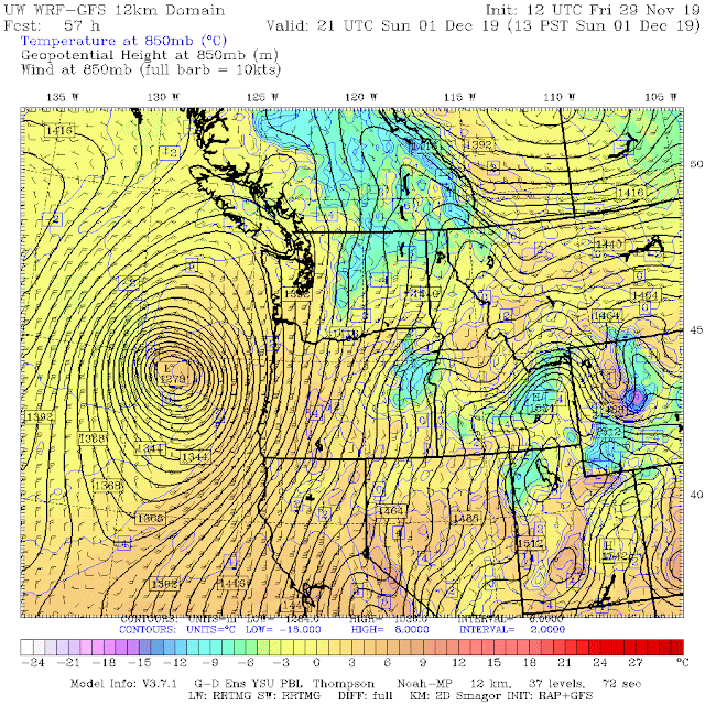
Moving to a level around 5000 ft (850 hPa), southerly winds and warmer temperatures (yellow/orange colors) over western WA are apparent. Not good for snow.
The latest UW WRF high-resolution snow total prediction through 10 PM Sunday, shows no snow near Puget Sound and some light snow at higher elevations. Just too warm.
Now, if it possible a few flakes could be observed when the precipitation starts in the Seattle area on Sunday morning, thanks to intense cooling from evaporation as the flakes fall into dry air below, but this will quickly turn to all rain. There could be a dusting just to the southeast of the Olympics and over the higher terrain of southwest WA. If you are driving on I5 over SW WA during the initial light snow period, slow down and making sure you have adequate following distance...we don't need another Spokane accident scene.
If you want more information, do what I do and go to Seattle SnowWatch, a website that has the best collection of snow/temperature data for the region that exists. This is a joint UW/City of Seattle project.
Finally, notice how dry this November has been. As described in my next blog, this has been the driest November since 1976!


Max temp in NW Bellingham today was 39.4F. Coolest daily maximum temp of the month, the season so far and the first daily max temp in the 30s since March.
ReplyDeleteMax temp near Sandpoint, Idaho today where I am was 28.7 degrees, also the coldest day I've observed since March.
DeleteIt was actually 15.8 this morning in Glacier WA, and we're only at 906 ft...not alpine! Valley. I'd love to see some clouds, for the warmth!
ReplyDeleteAny word on mountain snowfall anytime soon? I assume this upcoming system won't drop much.
ReplyDeleteMin temp in NW Bellingham today was 23.2F. Coldest of the month and the season as well as the coldest reading since March.
ReplyDeleteWhen you have different things screwing our oceans up it also screws the weather up as they make storms steer the wrong way and our ice in Alaska has been dumped by the TONS into Fukushima since 2014 to keep the (buried) reactor from blowing up half of Japan. Robot 5 last year their strongest robot didn't even get anywhere NEAR the core before melting. Fukushima is still putting out lots of crap mostly spewing into the ocean heating it up and it spreads across to the Central Pacific (Gasp) this is where all the warmer then normal water has been lately! WOW! Whatdayaknow.
ReplyDeleteI would like to see some objective sources for this claim. Not saying it's not valid by any means, but I can't find anything yet to support it.
DeleteBreaker, breaker, TruckerTucker. A heaping steaming pile to unpack in that paragraph. Rodger Dodger, Vector Victor! Over and out Captain Over.
Deletetoday, lake bosworth it was 15 this morning and cold
ReplyDeletereply to my comment with how much snow you think we will get tonight and sunday
ReplyDeletehey cliff if you can comment on my comment scott at komo is friends with my dad im 14 and want to start a blog my self what do i need to do to get a name and how do i start a blog on what plat form and social media ?? im asking you please
ReplyDeletehttps://startbloggingonline.com/ Start here for some ideas.
DeleteIf you like to hit rocks, don't mind skiing down the rocky fast low elevation summer trails where the snow cover is too thin to ski or don't mind walking down lower elevation steep rocky slopes, then the Backcountry skiing is good at Washinton Pass right now. :)
ReplyDeleteHowever, the local cross country ski enthusiasts have set ski track on the Washington Pass Overlook Road and the cross country skiing is good in the "meadows".
Chris H.
Heli-free North Cascades