One sign of the percolating atmosphere was a tornado that hit the north side of Richland, Washington yesterday (Tuesday) afternoon around 2:45 PM.

This picture was taken by Gabriel Sanchez and was part of a video he made:
https://twitter.com/i/status/1245135193154801665
A satellite image near the time of the tornado shows a line of convection/thunderstorms extending over Richland (see below). I put a black oval around the tornado location. You can also see a number of convective storms bubbling up over the western side of the state as well.

The NWS Pendleton radar imagery at the time of the tornado (2:46 PM) was not exactly impressive, but clearly showed the convective line (I put an oval around the relevant portion-- the image shows reflectivity, a measure of the intensity of the precipitation). You can see the most intense part (red spot).

The tops of the thunderstorms were wimpy--only around 15, 000 ft. Oklahoma folks would laugh at us!
And the Doppler velocities (below), showing the strength of the flow towards or away from the radar, did not indicate any rotation (which would be shown by contrasting colors signifying a couplet of flow towards and away from the radar).

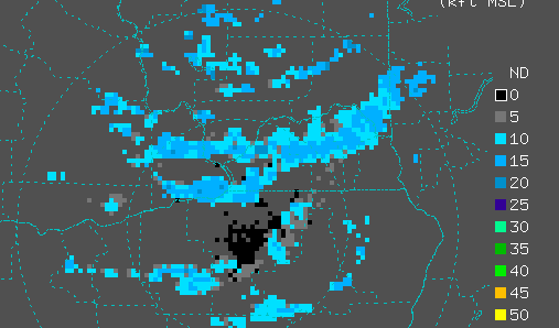
The UW WWLLN lightning detection network did sense some lightning in portions of the convective line, but to the east of the tornado (picture shows lightning strikes between 2:30 and 3 PM)

This kind of weak tornado, sometimes called a landspout, has a different mechanism from the big supercell tornadoes of the Midwest.
If there is a change of wind speed or direction over distance, that implies some inherent rotation (see schematic).


so, a giant dust devil, more or less?
ReplyDeleteNope. A weak tornado, even an EF-0, is still way more than a mere dust devil. And dust devils are formed by warm updrafts.
DeleteIs this the same mechanism by which the deserts spawn dust devils?
ReplyDeleteLooking east over Sinclair Inlet and toward the Cascades we saw a few Cumulus kind of clouds billowing upward, and one of them the beginning to form an anvil.
ReplyDelete