Residents of the Northwest are a savvy group regarding precipitation, considering their considerable experience with the wet stuff.
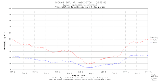
And the really precipitation-aware know about an interesting subtlety: the late-winter precipitation plateau and the mid to late March transition over western Washington. And the eastern Washington precipitation leveling during spring. And more.
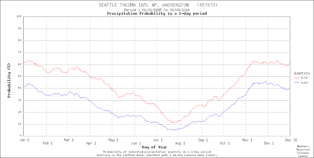
The wettest period at SeaTac is from mid-November through early January, when the incoming storms off the Pacific are strongest and more frequent. Then the probability of precipitation declines a bit in January, followed by little change through mid-March. Subsequently, from the last few weeks of March through early May, precipitation significantly declines. I call this the "spring drying."
Interestingly, there is a bit of an uptick in Seattle's precipitation frequency in late May--at the beginning of the June Gloom period. There are two reasons for this. First, high pressure building over the eastern Pacific starts pushing more moisture into the region during that period, resulting in light rain. Also, we can get some convection and thunderstorms during that period, as the stronger sun drives convective showers.

The subtleties of Northwest weather are always fascinating. You start with variations in the storms and moisture coming off the Pacific. Add to that changes in vertical stability and thunderstorms/convection as the temperature change with height changes by season. Varying winds during the year alter the effects of terrain (windward enhancement/lee rain shadowing). The precipitation story is complex and nuanced.


We had a few inches of rain here in Kingston yesterday. Damn PSCZ !!!
ReplyDeleteIt was sunny and windy in Port Townsend.
I guess we'll see if the pattern of dry hot June continues. Something has shifted. Maybe not historically, but triple digit temperatures and dry, sunny June is not the norm.
ReplyDeleteI'd be happy for a dry hot June as long as April and May have good precipitation.
DeleteI know it's not related to PNW weather, but would be really interested to hear Cliff's input on the "Antarctica 70 degrees warmer than average" headlines that have been in the news.
ReplyDeleteI second that.
DeleteYes, Cliff's take on the "heated poles" would be fascinating, I'm sure.
ReplyDeleteComplete opposite here in the Midwest. In the winter we have the least amount of precipitation, because cold air can't hold as much moisture. Then around April the spring thunderstorms really kick in due to the instability and higher dew point, which peak in July with dew point in the 70's and occasionally low 80's. We do get cold fronts in the summer which can bring the dew point down in the 50's which feels so nice and cuts down on the thunderstorms.
ReplyDelete