Announcement
I will be giving a talk on Northwest Weather and signing copies of my updated book (Weather of the Pacific Northwest) at the Northgate (Seattle) Barnes and Noble at 1 PM on Saturday, June 25th.
___________________
It is a well-known aphorism that it is always darkest before the dawn.
And this wisdom may prove particularly applicable to the weather situation this week. A major improvement will soon occur
But first, let's talk about darkness.
330 PM Friday in Seattle. It rarely gets worse than this in June.
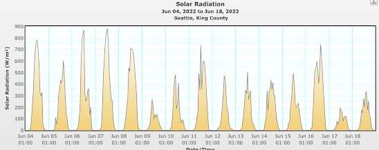
On Friday, Seattle only received 4.64 MegaJoules per square meter of the surface (Joules are a unit of energy). This is the darkest June day since June 2014. June 9th was almost as dark. And Saturday was only slightly brighter.
Full sun this time of year should be around 900 watts per square meter.
We have had several days with half that much
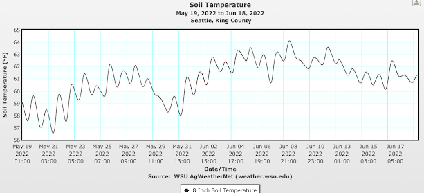
With cool, cloudy air over us, soil temperatures have stopped rising and started to decline, as shown by the soil temperatures at 8 inches in Seattle (below). Your tomato plants are not happy. No one is happy.
But I have good news. Leading weather forecast models suggest we are going to break out of this infernal situation, at least for a while.
The Key Problem
The main reason we have been so cloudy, wet, and murky has been persistent low pressure or troughing along or just offshore of the West Coast. Below is the upper level (about 18,000 ft) weather map for 11 AM Friday.
Mama Mia! A huge, high amplitude trough along the West Coast. No wonder it was dark and abysmal around here.
A persistent trough of one kind or another has been in place the last few months. And this situation is about to change.
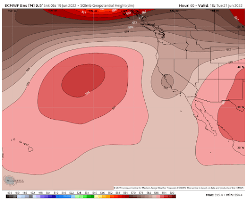
Examining the most potent, skillfull extended forecasting modeling system is the European Center's ensemble forecasting system. Its latest forecast suggests that the upper-level trough will move inland a bit and weaken by Tuesday morning (pink indicates higher pressure--ridging, brown indicates lower pressure--troughing). That will produce improving weather over the Northwest.
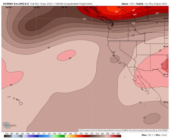
On Thursday, a strong trough will pass to our north and a weak trough will remain over California. This will produce some decline in our weather.
But things look better on Saturday, as a deep trough develops well offshore and weak ridging extends along the coast. A very different and MUCH more favorable pattern.
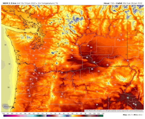
Sit down before I tell you the forecast for next weekend. Saturday's temperatures, predicted by the National Weather Service Blend of Models (below), show the upper 70s in western WA and mid to upper 80s in the Columbia Basin. Sunday will be nice as well. It will seem like Paradise after what we went through the last few months.
And one more thing, based on the latest extended models, there is no hint of any possibility of getting a crazy heat wave like last June. That was a black-swan event that will probably not happen again for many decades.





Its fun watching the Shift to summer occur
ReplyDeleteShift to summer? It's been fall/winter since October and in just ~8 weeks we're back to fall!
DeleteAaaahhhh! Sunshine!!!! My vitamin D levels thank the weather "gods."
ReplyDeleteI've been loving our extended dark and drizzly PNW weather
ReplyDeleteWell I guess you'll thrive during nuclear winter. No thanks. 👎🏻
DeleteEveryone likes sunny days and it can be sunny any time of the year. Reviews are mixed on anything past 80 degrees. Anything past 90 and it comes down to the misery of this area not having the ubiquitous AC of hotter regions, although with mini splits that is changing rapidly. Would rather have the drizzle as drizzle assures a good night sleep at least. Summer is generally speaking highly over rated. As others have said, let's just get this over with.
DeleteObviously many of you guys don't care about outdoor swimming!
DeleteOur rooftop solar is behind the pace it had in May, despite longer days.
ReplyDeleteAs have I, as I think I developed PTSD from the summers we had the last two years.
ReplyDeleteSo back to our regular hot summer, 80s, 90s and near 100 possibly minus the heatdome we had last june of course.
ReplyDeleteTim you really are funny! We don't have regular hot summers in the 80s 90s near 100. How long have you lived here anyway?
Deleteah well, it was too good to last, bring on the heat here in OR (90's forecast for this weekend), and let's get it over with.
ReplyDeleteI am always interested to learn about the 'why' of extraordinary weather conditions. Any idea why there has been so far this year a persistent low-pressure system off the coast? What changed in the atmosphere that allows such persistence?
ReplyDeleteThere has been a La Niña system in place all year.
DeleteSummer's imminent arrival is good news. I've certainly wished for a bit more sun and warmth, but then when I see much of the rest of country suffering through heat waves I realize cool and cloudy ain't really so bad.
ReplyDeleteWhere did you source your data for solar radiation and is that something accessible to a lay person?
ReplyDelete