Just a short note.
Last night, as marine air surged in, there was a rapid improvement in air quality around the region. The latest purple air map shows that all of western Washington now has good air quality. With strengthening onshore/westerly flow the wildfire smoke has been pushed into northeast Washington.

Expect improvements in the central and southern Willamette Valley later today.
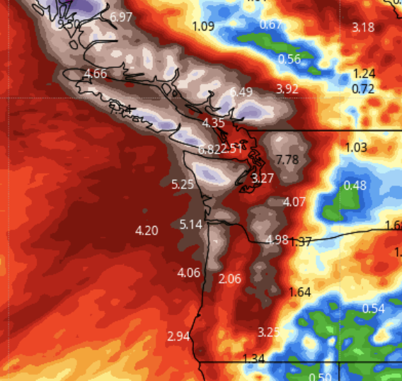
A series of distrubances in northwesterly flow will bring precipitation to the regon during the next few days, with the mountains getting the bulk of it. Check out the accumulated precipitation amounts through 5 PM Monday (see below). Several inches will fall on the western slopes of the Cascades, which will greatly diminish current fires. Temperatures will plummet and relative humidities will be high.
Due to the incoming wind direction, Puget Sound will be rainshadowed by the Olympics, and a profound rainshadow will occur east of the Cascades.

In short, we have gone through the transition to more winter-like conditions.
And we are not going back.
Below are the totals during the next ten days. Wow. I will get my umbrella out!
.png)


I'm taking Cliff's UW class via ACCESS this quarter and he has pointed out the air quality via the purpleair site several times this week. It is amazing how the air in the greater Seattle area and across the North Olympic Peninsula cleared in less than 24 hours thanks to a little rain!
ReplyDeleteHallelujah!
ReplyDelete$#&@*! Rain Shadow!!! At least it gets the smoke/fire component of Endless Summer gone. Guess more waiting and teasing in the rain dept until the storms track in from the South West. Always next month!
ReplyDeleteI second your emotion about that irritating rain shadow!...I recently found out, that where I live-Everett-gets about 7 inches of rain LESS than Seattle, due to those blocking (but beautiful!) Olympic Mountains. I guess I should be happy about that, but I am not. I enjoy rain, when it is predicted to show up.
DeleteThanks for all you do.
ReplyDeleteMy guess is that is it for the west-side fires. Some of the east-side fires will smolder, but not grow much. It is too late in the year for much to happen, even if we get a few sunny days after this stretch of rain.
ReplyDeleteHooray! The switch is flipped. Six months hence we'll be wanting for the sun. If only Mother Nature would mix it up a bit...
ReplyDeletePicked up 0.26" on 10/21 at my house in Bellingham, ending a 77 day streak without measurable precipitation - easily the longest in my record dating to 10/1/2015. The high temperature was 52.2 - the coldest since 5/21/22.
ReplyDelete