Frigid air has settled over the region, with the low temperatures today ranging from the mid-20s over the western lowlands to the teens and single digits in the Columbia Basin (see below). Temperatures dropped to below zero F over some valleys east of the Cascade crest.
The whole region is plenty cold enough for snow right now, there just isn't any moisture.
All the moisture is going into California right now. Good...they need it!
Friday and Saturday will be generally dry over the Northwest, with plenty of sun.
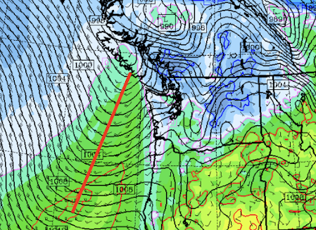
But Saturday night, a moisture source will approach: a Pacific occluded front (see forecast map for 7 PM Saturday night, black lines are sea-level pressure, the front shown by a red line, the near-surface temperature in color shades).
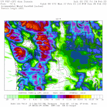
The front will bring moisture and warming, but the latest model simulations suggest that cold air will hold in enough in central Puget Sound to produce a few inches of wet snow on Sunday morning (see UW model forecast accumulated snowfall through 4 PM Sunday).
Lots of snow in the mountains.


A major issue was that the models underplayed the moisture circulating around a low moving down the coast, with a band of heavier precipitation hanging around Portland (see satellite image around 3 PM yesterday). Hard forecast.


This was a US forecast bust for Portland. The ECMWF nailed it:
ReplyDeletehttps://www.kptv.com/2023/02/22/wednesday-morning-forecast-track-so-far-snowy-models-stressing-out-forecasters/
So, per the comment by Cm77, why didn't the weather service give more weight to the ECMWF given its superior track record?
ReplyDeleteMaybe after this week's California storm the drought monitor Will ease up the intensity of the drought if not then there's no hope.
ReplyDeleteNo hope. Wow. I am grateful to understand science and reality so I don't live without hope. Thanks Cliff for being rational, scientific, and for having a a sense of humor!
DeleteOver the past ten years since moving to Portland, this numbers among the worst forecasts - but the city and the county again failed in their dereliction of duty regarding the roadways. They refuse to learn the lessons of past failures, and as result the entire county was basically rendered immobile. Tons of stranded motorists everywhere, some being left on the major highways for hours on end, finally running out of gas and having to try to walk all the way home. Contrast this scenario versus what played out just across the river into WA - the roadways were appropriately pretreated and cleared within hours, no big deal. Disgraceful.
ReplyDelete