Take a deep breath.
If you are in the Pacific Northwest, the air is very clean.
Its origin is from far to the Northwest: from the Aleutians and the Bering Strait.
Using the NOAA trajectory analysis software called HYSPLIT, I traced the path of the low-level air reaching the Washington coast (at 10, 100, and 500 meters above the surface) back for 96 h (see below). Straight to the Aleutians. You can almost smell the sea air.

The UW WRF model forecast for 1 PM on Saturday shows sea level pressure (solid lines), near-surface winds (the wind barbs), and low-level temperatures (purple and blue are the coldest). The low-level winds are from the northwest over and downstream of the Aleutians, consistent with the air trajectories above.
Our air started over the frigid Arctic, but you will notice it warmed up as it approaches us.

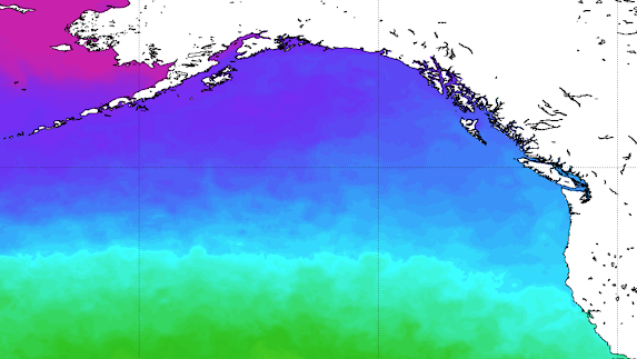
Because it passed over increasingly warm water. Here is the latest NOAA sea surface temperature analysis for the northeast Pacific Ocean, with purple and dark blue indicating the coldest water. The air reaching Seattle today was originally over the cold, purple colors (near freezing water), while the water near the WA Coast was in the upper 40sF.

As a result, the cold air at low levels north of the Aleutians progressively warmed as it headed toward us. In contrast, the air aloft (above roughly 5000 ft) stayed cool. The Arctic is above your heads right now.
Large changes in temperature with height result in atmospheric instability and mixing, often associated with cumulus and cumulonimbus (thunderstorm) clouds.

This progressive warming of low-level air, while the air remained cold aloft, resulted in an increase of the temperature change with height, with temperatures cooling rapidly in the vertical.
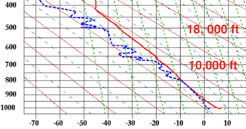
This rapid change in temperature with height was noted by radiosonde observation location on the Washington coast at Quillayute (shown below), with the temperature (red line) decreasing very rapidly in the vertical. (see observations at 5 PM on Saturday below, height is on the Y-axis, temperature, in C, on the X-axis)
Large changes in temperature with height result in atmospheric instability and mixing, often associated with cumulus and cumulonimbus (thunderstorm) clouds.
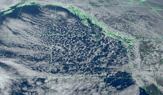
Thus, the northeast Pacific was full of instability clouds, producing the showers and sun breaks experienced in western Oregon and Washington today (see image below from Saturday around 6 PM).

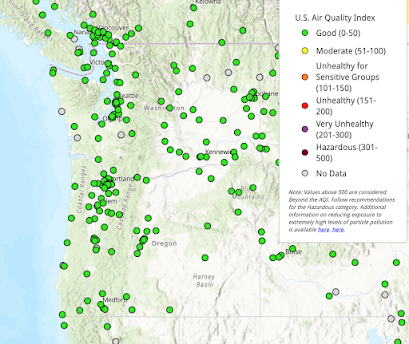
Above, I mentioned how clean this Pacific air is....here is the proof. Makes breathing a pleasure...


I can confirm that the air quality is exceptionally good at the moment as my outdoor air quality sensor is currently reporting an AQI of 0.0.
ReplyDeleteall I know it's much colder today than it was yesterday here NW of Olympia, sun breaks are sparse ,3 pm and the local NOAA station reports 37 degrees.
ReplyDeleteSunday afternoon at 5 miles NE of KELN - Ellensburg we had a few snowflakes in the air.
ReplyDeleteSpring might arrive here next Saturday. One can hope.
I wouldn't call it warm, Cliff. Much colder that average this past weekend, with hail as well- but I have noticed that the first week of April is often winter's "last gasp". Are we in meteorological spring yet? Hiked West Tiger 3 on Saturday: Lots of rime ice on top.
ReplyDeletePockets of frost this morning in Forks. And yes, the breathing is a joy.
ReplyDelete