Mother Nature seems to have forgotten about the current strong El Nino and the record warmth of the past month.
Massive snow will fall over the western mountains from British Columbia to California.

The Northwest ski season will be saved.
Our snowpack will be restored
And some snowflakes may even reach sea level over western Washington.
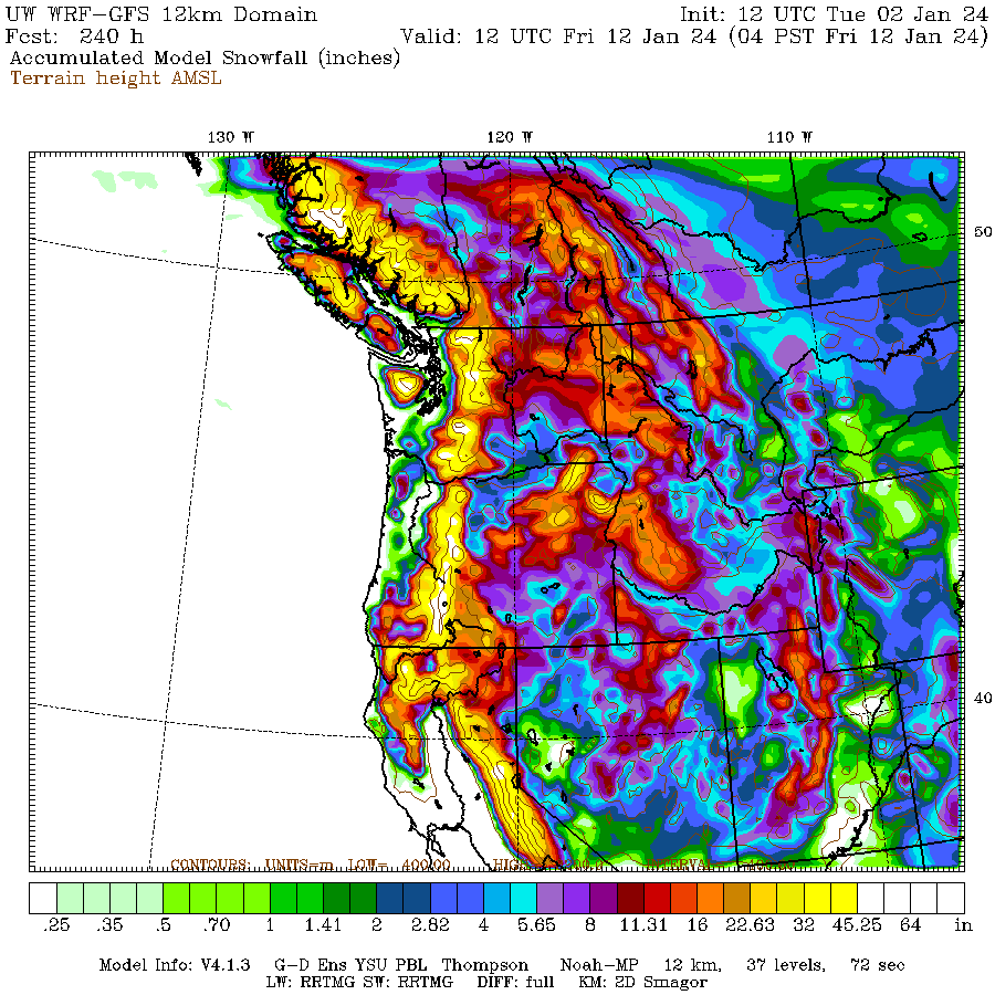
Let me start by showing you the accumulated snow forecast from the UW WRF forecast model.
Below is the regional snow forecast through Saturday morning for the West Coast and Washington. Some areas in the Cascades and British Columbia Coast mountains getting more than two feet! But this is just a "warm up"


The European Center model is doing the same thing (see the 10-day total below). Several locations getting more than 70 inches!

So why are we getting this snowy period when there was so much gloom and doom about El Nino?
It all has to do with the upper-level flow pattern.
This Saturday, an upper-level trough of low pressure/low heights will be moving in (the 500-hPa pressure level, about 18,000 ft is shown). A ridge is found offshore. The Northwest is in cool northwesterly flow. A very favorable pattern for mountain snow around here.


This is NOT anything like an El Nino pattern, which is characterized by a deep low offshore.
And now the real shocker. The latest European Center 30-day forecast is for much colder than normal conditions for our region! (see below). We will get a lot of snow and will stick around.
Get your skis ready!


Have we ever had heavy Mt snow happen during a strong El Nino winter before?. I'm also concerned about a very hot summer on the way due to a very strong El Nino, the CPC seems to think so based on their latest outlook for this summer.
ReplyDeleteEl nino is already showing signs its weakening and expected to phase in a neutral to la Nina pattern by end of spring. Heard a few experts even say it could be gone by February.
DeleteI also read this. Hopefully Cliff can discuss the dynamics of El Nino/La Nina cycles. The term "historic El Nino" was tossed about by the NWS, are strong La Nina and El Nino cycles always followed by abrupt swings and cycle changes?
DeleteInterestingly, I recently learned that El Nino's impact on summer weather (in the PNW at least) is relatively modest compared to winter. Here is the article that was shared with me and that I found really interesting:
Deletehttps://www.climatehubs.usda.gov/hubs/northwest/topic/el-nino-northwest-what-can-we-expect
Anecdotally (as in my 45 PNW ski seasons) we have indeed had some El Nino years with heavy mountain snow. Those seasons also featured some big warmup cycles with large avalanches and lowland flooding. As I recall the following summers never really got warm. Of course with global warming all bets are off.
DeleteSnotel currently has the WA Cascades and Olympics at <50% of normal as of January 3. Do you think the snow coming up over the next 10 days will be massive enough to bring us back up to normal?
ReplyDeletehttps://www.wcc.nrcs.usda.gov/ftpref/data/water/wcs/gis/maps/wa_swepctnormal_update.pdf
3-4 inches of snow water equivalent over the next 10 days will raise it slightly, but not erase the gap to normal.
DeleteBut it's still relatively early. Keep in mind, snowpack doesn't typical reach its maximum until April.
Good point, thank you.
DeleteHallelujah! It seems like the Cascades tend to see a dry period toward the end of January, so hopefully this will set things up at the ski areas to better deal with those conditions, should they occur.
ReplyDeletePicking a precise spot on these maps is sort of a fool's game, like buying a lottery ticket.
ReplyDeleteHowever, being a bit north of Ellensburg -- on the dry side -- but close to steeply rising topography toward Mission Ridge (6876 ft.), these maps indicate that I might get between 10 and 20 inches of snow and somewhat colder.
I need to stock up on beer and wine.
Thanks Cliff -- I'll warn friends that travel I-90 every week.
Cliff, you should consider a post discussing the Madden-Julian oscillation as I think many of your readers would find this to be interesting and edifying.
ReplyDeleteNot entirely surprising. All the hype about ENSO being determinative is not quite correct. ENSO only describes tendencies, not actual realizations, of actual weather. For example, the previous winter, during December22-January23-February23, we had El Niño. In terms of tendency, El Niño tends to lessen California precipitation. But what happened in actuality?- California had a record-high-precipitation winter during December22-January23-February23.
ReplyDeleteMy weather app is showing extreme cold 9-10 days out- highs in the low 20s. I know the forecast skill of these apps is extremely poor, but it will be interesting to see how it plays out, with the Euro models predicting anomalous cold for the next month.
ReplyDeleteWxU has 6"+ thru Saturday for us (750' WNW of Longview). I'll save it as a placeholder, and watch the model mutations kick in..
ReplyDeleteCliff Mass. Do you ever go back to your data and review actuals from the forecast? My data from NWAC.US shows about 60% snow accumulation from what was predicted in the WRF-GFS models --with even a 2 day forecast. I have noticed that in the past 5 years, that the WRF-GFS overpredicts the accumulation of snow. It is a common occurrence. I know we all strive for accuracy. I wonder why it is a regular thing the WRF-GFS overpredicts the accumulation of snow.
ReplyDelete