We are about to enter a very wet period, with the potential for bankfull rivers and even some localized flooding.
Let me start by showing you the total precipitation accumulation forecast over the next ten days over the region (from the European Center model, below).
Wow. Over ten inches in some locations in the Olympics and coastal mountains and 5-10 inches in the Cacades. Even significant precipitation east of the Cascade crest.
The UW model for the same period provides similar large totals, with over ten inches in the Cascades and Olympics and 3-5 inches over the lowlands of Puget Sound.
Temperatures will be cold enough to bring large snow totals. Below
is the prediction accumulated snowfall over WA State for the same period. Over FOUR FEET over the North Cascades and snow over lower elevations across the northern Columbia Basin.
The first major hit of rain and snow (in the mountains) will occur tomorrow (Saturday) and the a stronger event on Sunday night and Monday morning.
Let's take a closer look over the next few days.
Trough 4 AM Sunday, the regional gets a nice wetting, but nothing excessive.
But with heavy rain on Sunday night, by Monday morning, the story is very different.....very heavy precipitation totals in the mountains. A profound rain shadow northeast of the Olympics.
One day later (Tuesday at 4 AM), amazing totals over the mountains and even quite heavy south of Seattle. Continued rain shadowing from Sequim to Whidbey Is.
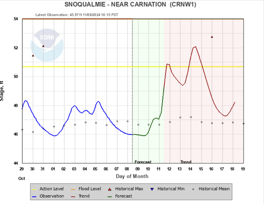
Rivers will respond. For example, the Northwest River Forecast Center is predicting that the Snoqualmie River will rise to "action levels".
This is climatologically the wettest time of the year, so it is nice to see that the atmosphere is following the calendar. 😁


The weather channel site says rain developing later in the day and as soon as this gets posted, I'm going out to begin stringing outdoor Christmas lights on the tree out front and will finish up in the morning while dry. Lights won't go on until Thanksgiving.
ReplyDeleteGood to see the rain, more or less on time, though it's been rainy off and on of late.
Is there a place I can get these precip forecast graphics? I've been looking and can't find them. We occasionally get flooded by our creek and they would be helpful in predicting when that would happen.....
ReplyDeleteMichael, I don’t have these links, but one additional graphic is https://psl.noaa.gov/data/obs/datadisplay/ViewDataType.php?DataTypeID=75&SiteID=fks&DataSourceID=%25 This the a vertical pointing radar at forks. The snow level black dots are a good winter indicator if we are in for a rain or snow dump. If we have a good low level snow pack and you see a high snow level in this radar then you may see some flooding as the rain washes out the snow. This often happens when we get winter/spring atmospheric rivers.
DeleteI appreciate that!
DeleteRain expected here (just north of KELN) at 4 pm. I have outside chores to do.
ReplyDeleteThe Grouse Camp SNOTEL
Bad keystroke - sorry. The site is 13 miles north of me. I can monitor the daily snow accumulation, but can't see that exact location. Some snow already visible there.
ReplyDeleteTis the season, yup. We started seeing snow at upper-elevations weeks ago. Onward ...prolly most of what we'll get is well within range of normal. I see the press (Bellingham Herald) has begun going zoo, though.
ReplyDeleteIt sounds like Washington State is really gearing up for some intense weather! I hope everyone stays safe with all this rain and snow on the way.
ReplyDeletebelt conveyor in India
Office Furniture Manufacturer