I have gotten a half-dozen emails asking about wind overnight.
Not the end of the world, but a strong front will be moving through. The Washington Coast and NW Washington will again get quite breezy, with some gusts reaching 50-60 mph. I expect far less damage this time, since the trees have already been heavily "tested" by previous events.
Over the interior of western Washington, the predicted maximum overnight winds are shown below, reaching 55 knots over the eastern Strait of Juan de Fuca. Those living on northern Whidbey Island should recharge their devices NOW.
Winds will be gusty near the water of central and southern Sound, but I don't expect many outages.
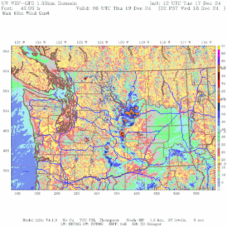
Looking at the maximum predicted gusts over the whole state through Wednesday evening (below), strong winds on the coast are evident.
But there is something else. As the front moves through, there will be VERY strong winds, with localized gusts reaching 70 knots. on the eastern slopes and foothills of the Cascades.
The last front that moved through resulted in a huge increase in the output of the wind turbines east of the Cascades (see below).
Thus, there will be LOTS of wind energy being produced tomorrow....so this is the time to charge your EV cars!


In Tacoma, definitely windy here. Awoke just short of 5AM this morning to breezy conditions and blowing rain. Lights have been blinking a few times, but not gone out, so far.
ReplyDeleteAround 4:30 this morning it really got quite breezy for a little under an hour in rural Thurston county. No wonder they extended the advisory past the original 4:00 AM timeframe. A few outages around the area, but hopefully PSE can get them fixed today.
ReplyDeleteAs of 06:40 AM, Seattle City Light, Tacoma Power, Puget Sound Energy, and Mason PUD3 are reporting over 80,000 households without power. There are more utilities around here, but I didn't check them. That's a bit more than was forecast.
ReplyDeleteWe had good east winds for a day and a half here just north east of Arlington, then just before 5 this morning a huge blast from the west. For a time there were 57 thousand people in the dark over snohomish county its amazing how that westerly surge comes down the Strait of Juan de Fuca after a frontal passage at times
ReplyDeleteHood Canal flooding homes again Cliff! The wind added at least a foot higher tide this morning, even with high-ish pressure! Super discouraging…and nerve wracking. Another king tide in early January :-(
ReplyDeleteHood Canal flooding again!
ReplyDeleteA doozy in the Puyallup area, large amounts of wind and rain. I'm in a spot that rarely loses power and we lost it at 530am and got it back about 945.
ReplyDeleteMorning Cliff - I was hoping you could do a post updating the ENSO picture?
ReplyDeleteHi, Cliff, will you be posting about how much rain fell/was measured on the Olympic Peninsula for this last rain event? I tried asking the Googleator, but it just gives me stuff about rain in WA. state as a whole. I know there are other sources but I'm not as dialed in to where that info. might be as much as some of the other fine folks who comment here.
ReplyDeleteThank you!
May I suggest you Google (probably one at a time works best):
Delete“nws noaa hoquiam daily precipitation stats December 2024” and
“nws noaa quillayute daily precipitation stats December 2024”.
Then, look for a link titled: “WFO Monthly/Daily Climate Data”.
Both places host National Weather Service data collection stations.
According to these early (preliminary) numbers, Hoquiam and Quillayute received 3.05” and 3.26” respectively on December 17 (Tuesday).
You can also get there via this web site, but you need to follow a series of links after that page loads, e.g.: Climate and Past Weather \> Local \> Observed Weather \> Preliminary Monthly Climate Data \> (selected location)
https://www.weather.gov/sew/\#
Hope this helps.
Yes!! Thank you, David.
DeleteI'll bookmark for future reference.
Is this a Pineapple Express?
ReplyDeletecliff..would love to see a blog on how the MJO phases influences our weather here in the PCNW...thanks for all you do...
ReplyDeleteHi Cliff, I'm sorry to bother you. How far in the future do your models pick up Fraser outflow events? The reason I ask is that I'm waiting on three subfreezing days in a row to defrost a freezer that badly needs it, and there's no freezing weather that I can see on the horizon. If we don't get the weather, I can't do the chore. Thanks so much.
ReplyDelete