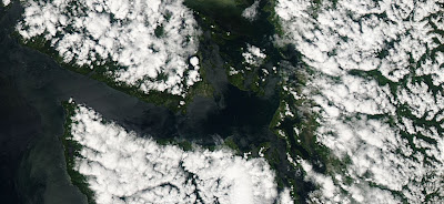
Sometimes having a boat (or getting a ride on one) is the ticket for getting some sun, and that approach is often useful in the spring here in the Northwest. The spring is the time of maximum instability of our atmosphere, the time when we see the most convective cloud and showers. The reason is clear: spring is when we have the maximum change in temperature with height. The atmosphere is still fairly cool, while the sun is near maximum strength and thus can effectively warm the surface. When the temperature change with height gets large enough, the atmosphere starts percolating (or convecting), with the upward moving air producing cumulus clouds.
Since the water does not warm quickly, there is little of this cumulus activity over local water bodies. Today's MODIS satellite imagery shows this very clearly. The picture above shows the 1-km resolution image from MODIS (the Aqua satellite), lots of clouds (cumulus) over land, but little over the Strait and the Pacific coast. You will notice a thin strip of the coast is clear; that is the zone influenced by the cool air over the Pacific at low levels.
Here is an even higher-resolution view (250-m resolution). Clouds tend to form preferentially over the higher terrain, and valley bottoms are often relatively clear. If you look closely, you will see some clouds forming over some of the bigger islands such as Whidbey and Orcas.
A weak frontal system is now approaching our coast...the Langley radar near Hoquiam shows it for offshore at 9:40 PM Friday night: We will see increasing clouds from this system Saturday morning and light rain should be generally limited to the northwest portion of the State. The situation should improve later Saturday as this feature moves eastward. Generally dry weekend for most.
This blog discusses current weather, weather prediction, climate issues, and current events
Subscribe to:
Post Comments (Atom)
Contrail Fest over Eastern Washington
The satellite imagery over eastern Washington this morning looked like someone had gone crazy with a white crayon, drawing many white lines...

-
Today may be the last day you will need air conditioning this summer in western Washington. And fears of wildfires west of the Cascade cres...
-
Over the eastern U.S., the passage of a strong cold front, with a rapid decline of surface temperature, is a frequent winter treat. In contr...


Fascinating; thanks Cliff!!
ReplyDeleteFascinating; the exact opposite of the lowland fog we see in December and January! Thanks Cliff
ReplyDeleteCliff,
ReplyDeleteInteresting. Since I live in West Seattle, I have noticed that. Lack of clouds over Puget Sound, but many cumulus clouds to the east and farther to the west. Thank you for the explanation.
Disappointing that none of the forecasts called for any significant chance of precipitation. We did a massive garage cleanout in Shoreline yesterday, left a few things in the yard overnight, only to hear rain on the roof at 5 in the morning. It rained solid for at least a half hour before slowing to the drizzle it's doing now.
ReplyDeleteI hate to ask, but where is our rain?
ReplyDeleteAnyone that leaves stuff out overnight in the Seattle area in June (and then complains it got wet) must be from New Jersey...
ReplyDeleteClose, Rod - the Carolinas. :)
ReplyDelete