Memorial Day Update
Yesterday's models ALL had a major timing error.....the front is coming in must faster than predicted and rain has just reached Puget Sound (see radar at 8:20AM below). So rain today. But perhaps this will allow the front to clear by dinner for some of you.
STEADY RAIN OVER BY 2-4 PM!
__________________________________
The forecasts were too optimistic for today for much of Washington. On Sunday morning, the radar shows lots of showers over the Cascades and the western side of the state and the visible satellite image shows plenty of clouds (see below). Yet the media were going for an improving trend as late as last nigth, with one TV station talking about sun and 70F on Sunday.
My forecast was online on this blog and updated in KPLU (my audio is found here)--and yes, it was not perfect. My take was that there would be clouds and showers on Saturday, with some sun breaks and that things would improve Sunday afternoon. That clouds and rain would be worse to the south. But there was something to be concerned about: the European Center model (ECMWF), the gold standard for numerical weather prediction, was bringing much more moisture and light rain into the region on Sunday than the U.S. models. The European Center forecast was right. And all the models showed a front approaching Monday, with rain spreading north during the afternoon. The current runs agree with this.
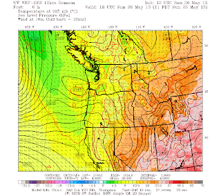
The differences among the models were subtle as were the errors in the U.S. model solutions. Let me show you what changed. Here is the UW WRF prediction for sea level pressure for Sunday at 11 AM that was initialized only a few hours ago-very close to the truth. You will notice a weak low over the coast--this is associated with moist southerly flow entering western WA and upward motion...bringing clouds and precipitation. In contrast, the second panel gives the forecast for the exactly same time but started on Friday morning ..no low and there was a weak trough off Oregon. This kind of small scale feature can be difficult to forecast and clearly the EC model did better.
State-of-the-art forecasting is not dependent on one model prediction and the UW local ensemble forecast (making several forecasts, all reasonable but different) for daytime Sunday that was made Friday morning showed rain south of Seattle but drier to the north (the graphic shows probability of precipitation from the UW PROBCAST sysem). In reality, the precipitation spread north to Vancouver because of the offshore low. And Saturday was nicer than expected.
So what about the rest of the day Sunday and Monday? The rain is now pushing northward and the Langley radar shows little behind it. So the coast is drying and soon the drying will push up into Puget Sound. The skies will brighten. Strangely enough, Friday's forecast for Sunday will still verify in one way...much better during the afternoon south of Everett. The visible satellite shows weak spots in the clouds behind....maybe a few sun breaks. So if you want to do something outdoors--there may be a chance this afternoon.
Monday will start off dry, but the next front should push in with rain during the afternoon (and clouds a few hours before that). Here is the UW WRF forecast for precipitation for the 3 hours ending 2 PM Monday. Keep in mind the timing could be off by a few hours. Watch the radar to plan your outdoor activities tomorrow. If you are planning a Memorial Day barbecue....be ready for rain, particularly from Seattle southward after mid-afternoon.
This blog discusses current weather, weather prediction, climate issues, and current events
Subscribe to:
Post Comments (Atom)
Contrail Fest over Eastern Washington
The satellite imagery over eastern Washington this morning looked like someone had gone crazy with a white crayon, drawing many white lines...

-
Today may be the last day you will need air conditioning this summer in western Washington. And fears of wildfires west of the Cascade cres...
-
Over the eastern U.S., the passage of a strong cold front, with a rapid decline of surface temperature, is a frequent winter treat. In contr...


You say: "State-of-the-art forecasting is not dependent on one model prediction."
ReplyDeleteIf the "European Center model (ECMWF), [is] the gold standard"
why was it not mentioned in your Thursday prediction for the weekend?
We're meeting friends at Folklife at 3:30 pm today (Monday) so your prediction of drying out by 2-3 pm makes me very happy! We do expect it to rain at least some at Folklife; we went Saturday from 7:30-10:30, and true to form, light drizzle started around 9:30 and then it picked up a bit until about 10:15, when it got lighter again.
ReplyDeleteWho cares? Folklife is still fun with some rain as it's rarely cold enough this weekend to be truly uncomfortable. :-) We've only had one year (2009, I believe) without measurable rain during Folklife in the 14 years I've been going, so it seems normal to have at least some. Folklife has many indoor venues and I enjoy the "thinning of the herd" that happens when it starts to rain at the festival....
I went all the way to Twisp for some climbing in the Chelan-Sawtooth range with at least partial sunshine. But we failed: Peaks were lost in the clouds and the sky was spitting snow at 7,000 feet Sunday, so we came home a day early. No bargain.
ReplyDelete