Midnight Update:
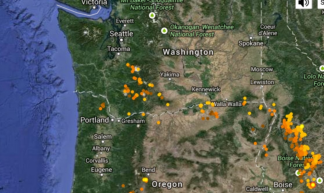
Heavy precipitation has moved into Puget Sound country. Here is the lightning over the past 24 hr (basically all day Tuesday). The most recent is yellow, followed by reds and purple. The Cascades have been hit very hard with lightning and right now the folks around Bellingham are getting the flashes.
_____________________________________
Last night thunderstorms hit portions of Western Washington and right now (3 PM) a band of heavy showers is moving northward towards Puget Sound. Note that particularly heavy precipitation is associated with thunderstorms over the southern Cascades (red colors).
Here are recent lightning strokes. The Cascades are getting hit by multiple strokes.
The forcing for all this activity is an upper level trough/low that is moving towards us now and which will circle around the area for the next day. To illustrate, here are the upper level forecast maps (500 hPa) at 5 AM and 11 AM on Wednesday.
Take a look at the 24h precipitation ending about 6 PM today. The south Cascades have been hammered by the thunderstorms, with some locations getting 2-3 inches,
Large amounts of precipitation for this time of the year...as much as 1-2 inches over the Cascades..are forecast during the next 72 h (see map). Eastern Washington will get a lot of precipitation, and they need it.
This blog discusses current weather, weather prediction, climate issues, and current events
Subscribe to:
Post Comments (Atom)
Contrail Fest over Eastern Washington
The satellite imagery over eastern Washington this morning looked like someone had gone crazy with a white crayon, drawing many white lines...

-
Today may be the last day you will need air conditioning this summer in western Washington. And fears of wildfires west of the Cascade cres...
-
Over the eastern U.S., the passage of a strong cold front, with a rapid decline of surface temperature, is a frequent winter treat. In contr...


.gif)
.gif)


Maybe it's a blip with the radar that KOMO is using, but it seems the large cluster of storms heading from the SE is dying just shy of the Canal, sparing Fremont, Ballard, and much of north Seattle. This is at 7pm. This obviously could change in minutes, but talk about unpredictable weather!
ReplyDeletesounds like flooding all over the region, with storm water systems not able to keep up in Seattle.
ReplyDeleteThere was a helicopter directly over my house (Phinney / Ballard) this morning from about 6:00 - 6:30 am. It must have been helping with flooding / power emergencies and traffic situations
We ended up with a bit over 1" of rain last night here in Fauntleroy. about .23" to midnight and another .9" after. We really needed the rain here, but Eastern Washington rain should be a game changer. If it starts to rain a bit it will start to knock down some of those wild fires.
ReplyDeleteThis from Chehalis; Century Link internet was down for more than 12 hours on tuesday. Could find very little about it on the internet when it came back. But I did find one map that indicated the outage was from north of Seattle to south of Portland!
ReplyDeleteI suppose it was weather related, one way or another.