And we understand in general why this distribution exists. Many of our barriers (such as the Cascades) are oriented north-south and winds approaching the terrain are generally westerly (from the west), since the large scale flow in the midlatitudes is westerly. So air is forced upwards on the western (windward) side, which leads to clouds and precipitation. On the other hand, air descends on the eastern (leeward) side, resulting in drying and less clouds/precipitation. 95% of the time that is what is happening around here.
But there are some situations that produce heavier precipitation on the other (eastern) side of the mountains, in this the Cascades, with heavier precipitation over eastern Washington than western Washington and far heavier precipitation on the eastern slopes than the western slopes.
Such a situation happened Wednesday to Friday of the week. Let me demonstrate this.
Here is the forecast precipitation for the 48-h ending at 5 PM Friday. Way more rain over eastern Washington than over the western lowlands.
This forecast was confirmed by the observations. For example, here is a weather radar snapshot for Thursday at 7:14 AM.
So why was precipitation on the eastern rather than the western side of the mountains?
The winds had reversed from the normal westerly flow to easterly (from the east) flow.
Why? Because a small upper level low had moved in over our region and this low caused the winds to reverse. Here are two maps (for 2 PM Thursday and 2 AM Friday) showing the upper (500 hPa, roughly 18,000 ft) flow. The solid lines are the heights of this pressure surface (you can think of them like pressure). The low is in the center and the winds are parallel to the lines with higher values to the right of the wind. The winds are also shown by the standard wind barbs. As the low center slowly passed south of Washington and then along the border with Oregon, there was easterly flow approaching the Washington Cascades. This air was forced to rise by the Cascades, enhancing precipitation on the eastern side.
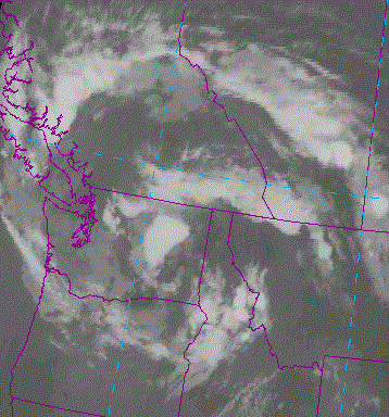
Satellite pictures showed the swirl of clouds associated with the low. Here is an infrared picture from Thursday AM.
Now there are other contributors to producing more rainfall over eastern Washington, such as when the air there is more unstable and warmer at low levels there, producing thunderstorms to the east of the crest, while the cool marine air on the west side is too stable for such showers. In fact, this was also happening on Thursday. Occasionally, some of the summer "Southwest Monsoon" moisture streams northward east of the Cascades, giving them some showers.
Thus, summer is a favored time for more precipitation over eastern Washington from thunderstorms/convection. You can see this from maps of climatological precipitation. On the left side, you see average July precipitation. A bit drier on the eastern side, but not by much (a few tenths of a inch). The Willamette Valley and eastern Oregon are almost the same. In contrast, the annual precipitation is another story, with the western lowlands getting about four times more than the Columbia Basin.
July Annual


Yes, Cliff. I noticed that. It seemed that a low was parked over the state, and was spinning moisture counter-clockwise.
ReplyDeleteIn any event, I welcomed the rain. A nice respite from my daily watering of a bumper crop of tomatoes...and Brussels sprouts...
Thanks for the explanation.