After a beautiful summer, with warmth and relatively dry conditions from mid-July to mid-August, a reminder that we are living in the Northwest often comes in late August: the first passage of the first fall-like system, usually a weak frontal passage. And just on schedule, one is now approaching us. As proof here is an infrared satellite image for 9:15 PM, Thursday.
You can see the frontal cloud band stretching from the central Pacific into British Columbia, with the swirl of a low pressure center off of SE Alaska. A visible satellite view of the frontal cloud band at 5 PM is shown below. Looks impressive!
The fact that the clouds are quite white in the infrared suggests the cloud tops of the band are fairly cold and high. Our coastal radar at Langley Hill, near Hoquiam, clearly delineated the rain within the front (at around 5 AM on Friday).
The latest forecast models suggest this band will spread over us Friday afternoon and Saturday. So Saturday should be the worst day of the holiday weekend.
Here is the forecast 24-h precipitation ending 5 AM on Saturday. Avoid British Columbia...that is where most of the rain will be. Washington and Oregon are generally dry except for some light showers on the windward slopes of the Cascades. True Northwesterners laugh at such light precipitation. But temperatures on Friday won't get much above 70F.
The next 24-h (ending 5 AM on Saturday) will be wetter, particularly over western Washington. But cross the Cascades and you will be out of it and most of Oregon should be dry, except its far NW corner.
For the 24h ending Monday at 5 AM, precipitation is mainly limited to BC and NW Washington. Again, heading to eastern WA or Oregon is the ticket to a dry outing. A Vancouver or Whistler trip could be wet, although a stop for dim sum in Richmond, BC. always good. Most of the rain comes in late Sunday and
thus most of the day will be dry. That is illustrated by the 3-h precipitation forecast ending 2 PM on Sunday. So Sunday is better than Saturday for most of western WA.
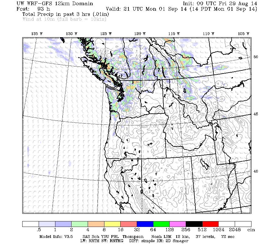
Monday will have light showers over western WA. Here is the forecast precipitation for the 3-h ending 2 PM.
So to reiterate my advice for enjoying dry outdoor activities this weekend:
Head to eastern WA or all of Oregon (except the far NW coast).
Sunday afternoon looks like a gap between weak systems.
Take your Gore-tex garments out of deep storage.
This blog discusses current weather, weather prediction, climate issues, and current events
Subscribe to:
Post Comments (Atom)
The Origin of the Puget Sound Tornado
Around 3 PM on Wednesday, a tornado was spotted over Puget Sound (see picture below). Technically, this rotating wind feature is known as a...

-
Today may be the last day you will need air conditioning this summer in western Washington. And fears of wildfires west of the Cascade cres...
-
Over the eastern U.S., the passage of a strong cold front, with a rapid decline of surface temperature, is a frequent winter treat. In contr...


yay. Finally :-)
ReplyDeleteSo excited for fall. This summer has been absolutely awful.
ReplyDeleteYou nailed it right on the head Mr. Mass. There always seems to be a small system in the latter part of August that turns the page of the summer pattern. Last year , we had record rainfall in September, a few last gasps of summer after that. Looks like the pattern may turn back to warm middle of next week, but signs point to an overall change to more climate norms after that.
ReplyDeleteEarlier this summer it had looked like the models were predicting a La Nina winter for us. In your opinion, is that still the case? There was the following report, but I always take a news report on doom and gloom weather with a grain of salt...http://empirenews.net/meteorologists-predict-record-shattering-snowfalls-coming-soon-bread-milk-prices-expected-to-soar/
ReplyDelete