During the last week, there have been several days when cumulus clouds were towering over our local mountains, such as the Olympics and the Cascades, while it was sunny and dry over the lowlands.
This is not unusual and is a frequent feature of our summer weather.
Let's talk about it and explore why it happens. To illustrate this, here are a sequence of visible satellite images from Thursday (May 28th). Starting at 8:40 AM, the mountains are clear, with the white near their crest being the snow fields. The extensive white clouds along the coast, the Strait, and southern Sound are stratus/stratocumulus (low clouds).
By 11 AM, you will notice increase white over the mountains...these are developing cumulus clouds.
By 2 PM, they are much more prominent, with some of them precipitating and developing anvils of ice clouds (fuzzy looking look).
At 4 PM, the clouds are a bit more prominent
The radar image at 4 PM Thursday shows moderate to heavy rain associated with the thunderstorms over the mountains. Might have dampened the hikes of a few folks.
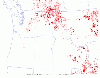
We know that some of the cumulus developed into lighting because the lightning detection network showed plenty over the Cascasdes, the Okanogan, the Rockies, and to some degree the Olympics (here is the 24h lightning strikes ending 1 AM Friday). They are over and immediately downstream of the mountain crests.
We can view the processes from ground, and what better location than Hurricane Ridge in the Olympic range? Here is a sequence of images showing the process.
So why do thunderstorms preferentially form over higher terrain?
There are several reasons. First, cumulus clouds and thunderstorms are often initiated by an area of upward motion. The atmosphere is frequently what we call conditionally unstable, which means that without vertical motion the air stay put, but if lifted enough, the air becomes buoyant...rising into cumulus towers.
And vertical motion is greatly enhanced over the mountain crests (see figure). Air tends to rise up heated slopes (something one often experiences when hiking). With air rushing up the slopes and meeting near the crest, there is substantial upward motion over the crest. Upward-moving air will tend to cool to saturation (air cools as it rises), producing clouds. And if the upward motion is sufficient, instability results as the air become buoyant.
There are other reasons that mountain tops are favored around here. For example, the lowlands are often flooded by cool, dense marine air (not good for thunderstorms), but the mountain crests are above such air.
If there is westerly (from the west) flow aloft, the convection (thunderstorms) are often blown to the eastern side of the mountains (as happened on Thursday). The eastern slopes of the Cascades have received substantial amounts of precipitation from mountain thunderstorms the last week or so, something that is aiding the water situation in Yakima County and other eastern slope regions.
Announcement:
I will be giving a talk on the future of NW Weather on June 7th at 7 PM in Hansville on the Kitsap Peninsula:
http://www.brownpapertickets.com/event/1466229
This blog discusses current weather, weather prediction, climate issues, and current events
Subscribe to:
Post Comments (Atom)
A Very Strong Cold Front Will Cross the Northwest on Tuesday
The Northwest is known for its weak cold fronts, since the relatively warm Pacific Ocean warms, near-surface, cold Arctic air before it arri...

-
Today may be the last day you will need air conditioning this summer in western Washington. And fears of wildfires west of the Cascade cres...
-
Over the eastern U.S., the passage of a strong cold front, with a rapid decline of surface temperature, is a frequent winter treat. In contr...


In a typical year the melting snowpack would add moisture at an ideal place to build clouds; I suppose even atypical years do their part!
ReplyDeleteYes, I went on a hike on Thursday in the W. cascades and saw a mild thunderstorm.
ReplyDeleteThis kind of mountain weather is also common in the Sierra Nevada and Southern Rocky Mountains.
ReplyDelete