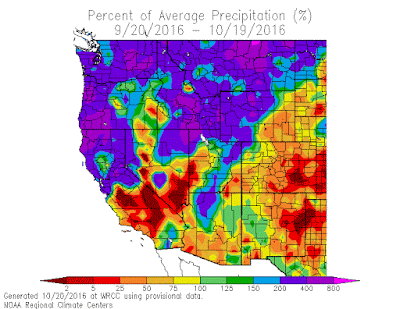
Let's start with percent of normal precipitation for the past 30 days over the western U.S. Much of Washington and western Oregon had more than 200% of normal, with large areas ABOVE 400% of normal.
A plot of observed precipitation (red line) and normal (blue) at Seattle Tacoma Airport shows the increasingly soggy story. August and September were drier than normal, but around 7 October the atmospheric spigot was turned on and precipitation totals have surged above normal.
As of 5 PM today--Thursday, October 20th-- Seattle's October precipitation total is 7.38 inches, 5.53 inches ABOVE normal for the month. If you are still watering your garden, stop. The monthly record is 8.96 inches and we surely have a shot at it, with 1/3 of the month to go.
With all this rain, Seattle's reservoirs are starting to refill rapidly (red line in figure below).
We are probably going to get a break on Saturday, but it looks like wet conditions will return next week (see NOAA Climate Prediction Center 8-14 day forecast below)
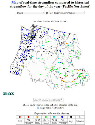
With all the rain, most of our local rivers are running well above normal:
And the short-term drought indicators show wetter normal soil conditions.
With all this rain in the Northwest, the official US Drought Monitor still shows drought over Oregon and the SE corner of Washington (yellow and orange colors). Puzzling.
So, if you are a human, find your umbrella and Goretex jacket. If you are a duck, smile and enjoy.
______________________________
Please support I-732, the revenue-neutral carbon tax swap, which will help reduce Washington State's greenhouse gas emissions, make our tax system less regressive, and potentially serve as a potent bipartisan model for the rest of the nation. More information here. Some opponents of I-732 are spreading false information, suggesting that I-732 is not revenue neutral. This claim can be easily disproven as discussed here. I strongly support I-732 as do many UW climate scientists. We have an unprecedented opportunity to lead the nation in reducing carbon emissions and to establish a model that could spread around the country.
Please support I-732, the revenue-neutral carbon tax swap, which will help reduce Washington State's greenhouse gas emissions, make our tax system less regressive, and potentially serve as a potent bipartisan model for the rest of the nation. More information here. Some opponents of I-732 are spreading false information, suggesting that I-732 is not revenue neutral. This claim can be easily disproven as discussed here. I strongly support I-732 as do many UW climate scientists. We have an unprecedented opportunity to lead the nation in reducing carbon emissions and to establish a model that could spread around the country.


haha if you're still watering your garden. Rice and cranberry garden. We all enjoy this rain. I live in the desert and we appreciate every drop and great to see our resevoirs already filling. I distinctly remember last year the first major storm to hit the NW occurred on Halloween weekend so this is a nice head start.
ReplyDeleteA wet winter? Will be interesting to see. :-)
ReplyDeleteI remember a discussion of the Drought Monitor being erroneous in their measurements; something about the way they measure the moisture content, coupled with their extremely long lag time in changing their designations? Maybe someone else can help my memory here.
ReplyDelete@Buddy, end of October is pretty typical for the start of rainy season around here and alaways seems to start with a bang. The spigot slowly starts to turn off around mid December, with the winter drizzle pretty common by mid January. Guess this puts us about 3 weeks ahead of schedule, that rainfall total wouldn't be breaking any records in Novemember.
ReplyDeleteOn another note, I wanted to give a shout out to my 'smart' irrigation controller. In the spring I installed the Rachio Iro controller and so far have been very happy. My annual zone was last watered in early October, my lawns last watered in late September, and my trees and shrubs last watered in late August, all without me lifting a finger. I was even able to have Iro use hyper localized weather data by configuring it use my PWS data on weather underground.
These storms been stirring up the warm blob. Will you post the SSTs next time?
ReplyDeleteThere's another typhoon hitting China...anything in the long range that hints at the moisture and energy from it coming our way?
ReplyDeleteCliff - if you're interested, here's some fascinating news on the carbon front:
ReplyDeletehttp://www.popularmechanics.com/science/green-tech/a23417/convert-co2-into-ethanol/
Now, if car manufacturers can develop more efficient engines to burn ethanol instead of oil, that would be a game changer. This bears close watching, one would think.
My ideal Fall starts with a little rain early in October and then an Indian summer followed by November bringing the party to a wild and wooly close.
ReplyDeleteBut no Indian summer this year. The conversion to daily rain has been a bit challenging for me, and I normally like rain. Just a mental thing, but somehow it's harder to make the adjustment this early.
I look out at my unfinished yard projects while standing dry and warm inside the house, and decide they can wait until things dry out a bit.
Likely I'll be standing in the window saying that until April. Or May. Or June.
The USDM is a political index (finding drought where none exists) rather than a hydrometeorological index.
ReplyDeleteNice post. One thing -- would it be possible to add a description of the typical variation in rainfall about this time? I like medians along with an interquartile range, but there might be some other more common meteorological approach.
ReplyDeleteMy rain gauge on south Vashon reports 8.78 inches for the month. Including the 0.05 inches today, Oct 21. This month's precip spread between SEATAC and my location is a little larger than usual.
ReplyDeleteVashon's only source of fresh water is that which falls from the sky.
I live northeast of Pasco and we are not experiencing a drought. We are dripping wet and are in essence Western Washington without the trees. Oh yes, we can see Mt. Rainier and Mt. Adams regularly just west of my house. No drought here.
ReplyDeleteThere's a very nice write up of Prof Mass and his clarion call for improved/updated U.S. weather forecasting computer infrastructure in today's (October 23, 2016) New York Times Magazine (page 26). Nice colorful figures, photo of our special authority, and well presented text at the national press level. Congratulations! May it grace more than a few Congress-person's coffee tables.
ReplyDeleteSo is the California drought finally over, then?
ReplyDelete