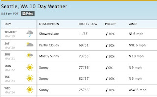
The first 80F day of the year in Seattle is always a reason to celebrate, and it looks like Tuesday (and possibly Monday) may be it.
Here is the latest forecasts of the National Weather Service, showing 80F for Monday and 85F for Tuesday..
And the even more skillful prediction of weather.com is going for 82F on Tuesday.
The origin of this warmth is a strong ridge of high pressure that will building over the region on Sunday and Tuesday (the map for 5AM Tuesday for 500 hPa...around 18,000 ft.. is shown below).
The surface pressure and low level temperature map for Monday at 2 PM shows the typical warm-period set up, with a trough of low pressure caused by warm air extending from California into western Washington.
Saturday morning will have considerable low clouds and a few sprinkles over western WA, but by afternoon the clouds should then and temperatures should rise into the mid-60s. And it is only up from there.....
This blog discusses current weather, weather prediction, climate issues, and current events
Subscribe to:
Post Comments (Atom)
A Strong Morning Inversion Undermines Air Quality and Messes Up the Coastal Radar
This morning, a strong low-level temperature inversion caused the air quality to decline over western Washington and created false radar ech...

-
Today may be the last day you will need air conditioning this summer in western Washington. And fears of wildfires west of the Cascade cres...
-
Over the eastern U.S., the passage of a strong cold front, with a rapid decline of surface temperature, is a frequent winter treat. In contr...


I'm seeing temps of 77 after or around Memorial Day. Could this possibly refuel the BLOB?
ReplyDeleteI'm adding the bog-creature chorus and saying NOOOOOOOOOOOOOOOOO. Please keep my temperate mild spring.
ReplyDeleteThe prediction of a warmer summer again makes me rather sad.
I noticed Sunday morning that NOAA has revised the temperatures downward for the Sequim area this week. Monday forecasted to barely reach 70 now, Tue only 65 with a stronger than earlier anticipated onshore flow that will cool things, at least out here. Seattle will likely be a little warmer as usual.
ReplyDeleteI'm presuming the ridge is turning out to be weaker than first thought.
Which is fine with me. Low 70's are fine as an upper limit. No need to ever get warmer than that. Looks like a perfect week with mostly high 60's fading to low 60's and some clouds returning on Wed. Now if we can just get a little rain out of this.
Either way, a perfect week for gardening. So far, the second half of May is about perfect, other than being a bit too dry in Sequim. Today's task is to rehabilitate my drip irrigation system after the winter sojourn. Going to need it soon.
bring it on.
ReplyDeleteI'll be hiding in my AC for the next 2 weeks. I seriously hate weather above 70 degrees.
ReplyDeleteJohn,
ReplyDeleteSome of us like to swim outside. Except for Polar Bears (the animal as well as members of a club by that name) swimming in a natural body of water is simply not possible without some hot weather, because the lakes (forget the Sound) will not heat up into the 70's with a steady diet of cool cloudy weather.
No 80 at the Admiralty inlet!
ReplyDeleteLooking at 58 for a high Wednsday, with a major on shore flow windstorm Tuesday afternoon.
John,
ReplyDeleteYou are partly right. The fact is we DO get hot spells- in most years, if you are patient and watch the weather, you can find swimming opportunities. I have, during properly timed trips, swam a mile or more in lakes as high as 3000 feet, always without a wet-suit, usually between July 15 and August 15.
As for New England, I grew up in southern Connecticut, and we swam every day in summer camp, the lakes typically reach 78 degrees for a couple months, even though they freeze over in winter.
But you're right, I sometimes feel the urge to visit Hawaii.