An unwanted California import is now approaching and on satellite photos its ominous tendrils are reminiscent of dementors and deadly hallows of Harry Potter fame.
A recent (11 AM) visible satellite image is worrisome (see below), with northward-bound smoke from California now extending over most of the Oregon coast and starting to extend above the southern Willamette Valley.
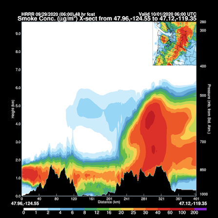
The greatest concentrations of smoke will remain aloft over western WA, but some will reach the surface here in Puget Sound. To illustrate, let me show you the predicted smoke in an east-west vertical cross section across Puget Sound (the valley between the two mountain ranges in the cross section).
At 10 PM tonight, smoke, some of it dense, will be above Puget Sound at elevations of roughly 10,000 to 20,000 ft. The moon will be obscured a bit.
11 AM Wednesday morning will see the smoke layer lowered with modest concentrations of smoke reaching the surface. Probably not enough to be hazardous, but some sensitive folks might notice it.
And smoke sticks around at low levels through 11 PM tomorrow (Wednesday), with modest concentrations at the surface. This is nothing like our last smoky period, but skies will be hazy.
Unfortunately, the atmospheric pattern, bringing smoke up from California, will continue through Thursday.
___________________________________________
My 101 Class
As I have mentioned before, I am teaching Atmospheric Sciences 101, an introduction to weather and climate, this fall. Not surprisingly, it will have to be online (Zoom). But perhaps this is a rare opportunity as well.
As you know from this blog, I am really into outreach to the community through my blog and podcast (and previously my radio segment on KNKX). I would like to try doing outreach this quarter with the online 101.
If you are over 60, you can sign up for the wonderful UW Access program, where for only a few dollars (I believe 5), you can audit UW classes. So I encourage all of those interested in taking the class to do so. Access students can't register until the third day of class, but I can give them the zoom address.
The class meets M-TH at 9:30 AM starting this Wednesday (Sept. 30th). The class outline is here.
_______________________________________________
My latest podcast:
If you would like to support the creation of the podcast, please visit my Patreon site.
Stream the podcast from your favorite services:


Nooo! I was hoping for one last week of sun & warmth to push my tomato plants over the hump and actually make a tomato. *sigh*
ReplyDeleteUs too... *sigh*
ReplyDeleteOh well!
Cliff, I’m curious if we can expect the HRRR models to be more accurate this time around? Has there been enough time to improve them based on data from the last round? Hopefully no inversion this time as well...
ReplyDeleteAnd I was just starting to recover from the last bout of smoke.
ReplyDeleteCliff, any chance you'll be teaching online next quarter? I really want to audit the class; it's on my bucket list! But I can't this quarter.
Tonight, the smoke is making my Mars and Moon observing more pleasant, despite knowing it is a menace.
ReplyDeleteTonight, the smoke is making my Mars and Moon observing more pleasant, despite knowing it is a menace.
ReplyDeleteHow do I get the zoom address for tomorrow and Thursday?
ReplyDeleteCliff, I registered for your course through UW Access. I'm really looking forward to filling in some blanks in my weather knowledge. The UW has acknowledged my registration, but hasn't provided any info concerning how one accesses the lectures. You mentioned above that you can provide a zoom address. Please do.
ReplyDeleteFor all signed up for 101, please email me to get the zoom address...my email is easy to find online...cliff
ReplyDeleteTodays blog is a classic example of why I keep coming back to this site for information. Just looking at the "vertically integrated" maps paints an entirely different picture than what is likely to occur on the ground. Most sites wouldn't even bother to point out they were showing vertically integrated data. This one goes further and shows some vertical cross-sections where I can see and plan based on altitude and timing. Of course, these are model-based predictions, but still - the devil is always in the details. Thank you.
ReplyDelete