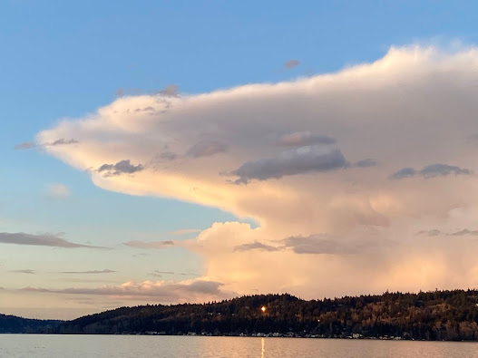
Thunderstorms in western Washington are a wimpy lot.
Infrequent and weak, they rarely get above 15,000 ft, unlike their vigorous cousins over the central and eastern U.S.
The reason for their weakness? Mainly the cool water of the eastern Pacific, which lessens the warmth at low levels and the water vapor content available in our region compared to the thunderstorms over the eastern half of the nation.
When thunderstorms are vigorous and strong they can rise high enough to reach the stratosphere, where warming conditions and dry air act as a barrier to thunderstorms' upward penetration.
And when they hit this barrier, typically 25,000 to 35,000 feet above the surface, the thunderstorm clouds tend to spread out in what is known as the anvil (see pictures below). From the first picture, you can see why it is called an anvil, a familiar item of the blacksmith's trade.
Now we rarely see anvils in western Washington, so you can imagine my delight when I walked outside yesterday (Tuesday) around 6 PM at the NOAA facility in NE Seattle and looked up (see imagery). A beautiful thunderstorm with a well-defined anvil!
The thunderstorm was very evident in the weather radar at this time, as shown by the radar image at 5:51 PM (left panel), with the associated heavy precipitation (reddish colors) just northeast of Everett (my location shown by a blue circle).
The radar can also tell us the top of the radar echo. I was shocked by the value, shown in the right panel: 26,000 ft. Wow.
The visible satellite image at this time clearly shows the big cumulonimbus cell (see below--I put a dashed oval around the thunderstorm)
There were several lightning strikes associated with this thunderstorm.
Was this thunderstorm entering the stratosphere?
To determine the height of the boundary between the troposphere (the lowest layer of the atmosphere) and the stratosphere, also known as the tropopause, we can examine the vertical temperature and moisture sounding at Forks, on the WA coast, valid at 5 PM Tuesday (see below).
Temperature is the red line and dew point is the blue dashed line. Temperature generally decreases in the troposphere and stops declining and eventually warms in the stratosphere (due to heating of the ozone layer by the sun). Moisture drops in the stratosphere (the dew point drops precipitously).
The locations of the tropopause in this sounding is very clear and indicated by the red arrow: about 7300 meters (or 24,000 ft). Actually quite a low stratosphere height.
So our energetic thunderstorm had enough meteorological "oomph" to push into the stratosphere....something known as an overshooting top.
And here is a marvelous video of the anvil pushing northward, from a viewpoint on the north Kitsap Peninsula (Skunk Bay Weather website).
An unusually tall thunderstorm for around here with a very nice anvil.
And if you ever want to see the best anvil picture for the region of all time, check out this amazing image by
professional photographer Frank Jenkins. Visual poetry. He kindly allowed me to use this image in my Northwest weather book.
_____________________________________
Before you renew support for Public Radio Station KNKX please read this.


Cliff, do you have a thunderstorm frequency map, or lightning strike frequency map, of Western Washington? (Admittedly low frequencies, but I'd be interested in the locations of the relative "hot spots".)
ReplyDeleteExcellent
ReplyDeleteBeing from the southeast US and experiencing Tstorms regularly it is nice to see one here. Being an aviator I have studied weather in order to stay alive.
I have no idea why people in the area love these storms so much. I grew up in Florida where EVERY storm comes with damaging lightning and I don't miss it one bit.
ReplyDeleteYou wouldn't love it if it brings down trees on your property, knocks out power several times a year or seriously damages stuff on your property often.
Delete"The dew point drops precipitously". Cliff, you are more humorous than you might know. Love your blog.
ReplyDeleteI decided that Tuesday was a good day to do a bike ride around Lake Stevens and ended up getting caught up in this storm. I was riding west along the shore and the sky over the lake looked pretty dark in contrast to a thin band of clearing along the western horizon. I saw the lightning and heard a loud crack of thunder and at that point it hadn't started to rain so I just hoped that I'd be able to finish the last couple of miles without getting dumped on. About a minute after the thunder, the wind got briefly intense and it started hailing. I figured the sky was gonna let loose at that point so I sought refuge under a tree but after I was out of the elements, all it really did was lightly hail/rain for about 10 minutes. It sounds like I caught the fringe of the storm but not a direct shot, and I'm thankful because I did not leave the house expecting it to rain, so I wasn't really prepared for it.
ReplyDeleteKMD... glad you are ok. Keep in mind, it is often a bad idea to take refuge under a tree during a thunderstorm....for obvious reasons!..cliff
DeleteSo they are rare in western Washington, but what about the interior of Washington. Say around the dry wenachee area
ReplyDeleteIs the stratosphere often that low here? That last incredible photo also seems to have low anvil tops
ReplyDeleteIt's weird to hear you say that thunderstorms with anvils are so incredibly rare in W-WA. They're a very common occurrence here in Western Oregon... on the rare occasion we actually DO get thunderstorms, they're almost always topped with that flattened anvil. Does our ~200 mile distance really make that big a difference??
ReplyDelete