My new podcast is out (see below) and in it I describe the hurricane-force storms that can hit Northwest and provide an update on the extraordinary Sunday/Monday event.
And I have to admit something: meteorologists are not exactly sure where the big storm will make landfall.
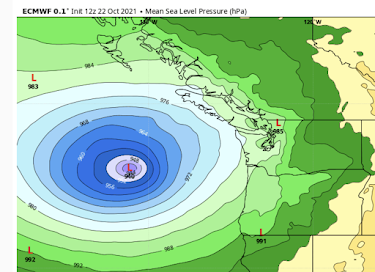
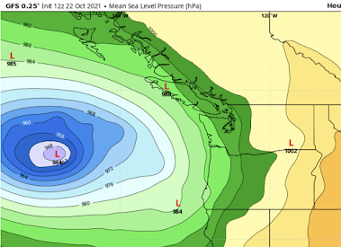
However, the formation of an unprecedented storm is nearly a sure thing, with the very latest forecasts of sea level pressure for Sunday morning from both the U.S. and European models predicteing the strongest Northwest storm in history with pressures below 945 hPa (see below). Just crazy. Equivalent to a category three hurricane.
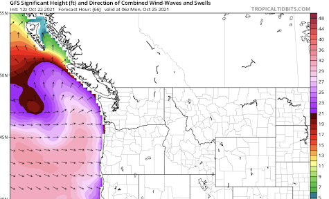
The strong winds and vast size of the storm will send large swell and wind-driven waves onto our coast, with some getting to 30 ft or more. Be careful if you go wave watching.
In the podcast, I talk about the disagreement between the models on where this monster storm will go, and how it will weaken over time. I will blog about this issue on Saturday....so keep tuned.
You can listen to the podcast below or through your favorite podcast server.
_____________________________________________


Thanks Cliff! We are just past the Elwha river in the 983 and 985 "zones" on the Olympic Peninsula. Praying for good news...
ReplyDeleteSorry, 983 and 992. Any idea what wind speeds may be associated with our "band"?
ReplyDeleteI thought a storm in the north pacific was called a hurricane
ReplyDeleteThanks for the updates as always Cliff! Wonder what the peak gusts will be in the Willamete Valley, I'm thinking mid 40s.
ReplyDeleteThanks for the updates as always Cliff! Wonder what the peak gusts will be in the Willamete Valley, I'm thinking mid 40s.
ReplyDeleteDo you have any indication (or several possibilities) of what this will look like? I live on Marrowstone Island. There is a ~150ft bluff we're on, so aside from erosion I think we're okay from the waves perspective. However, there are a lot of trees around the house, and we have some larger items out on the porch. Do you think it's likely (or even possible with this storm) for the winds to pick up heavy items and throw them around? What about damaging a tin roof? I'm more worried about the wind damage, because I don't know what that could look like. I know we'll probably have trees falling, but other than that I have no idea.
ReplyDeleteThank you,
Fiona
I'm curious to see what this storm will do to SW WA- the area around Ridgefield, Battleground, Vanc. We are pretty far inland, but the Columbus Day storm did a number on the area. Would love some comparisons in the predictions.
ReplyDeleteI was planning to visit Tofino on Vancouver Islands west coast this Sunday Oct 24th. This stretch of coast line is known for the ultimate for wave watching. Question is, Would this be life threating to do so?
ReplyDeleteWave watching at Tofino on the west coast of Vancouver Island this Sunday. Is this too risky to do?
ReplyDeleteWave watching is such a fun and exciting experience for those of us who like to stroll our Washington State beaches in fall and winter and to feel a strong wind in our faces and to experience the full force of nature raging against our bodies.
ReplyDeleteBut now Cliff Mass is telling us that this storm's waves will be somewhat more dangerous than the other fun and exciting storm waves we've usually watched in the past.
My wife is invoking Murphy's Law of Beach Strolling (MLoBS) and is predicting that if we travel to the coast to watch what's happening on the beaches this weekend, the Cascadia Fault will also let loose with the Big One just to put us all in our proper places.
OK, I yield to her suggestion. Maybe we'll do it some other weekend, assuming we can still afford the gas it takes to drive the two hundred miles to the coast.
Thank you Cliff for this update. Quite spectacular imagery and convergence of elements. I was 12 during the Columbus Day storm of '62. Stanley Park in Vancouver was permanently altered through blow downs and the idiotic solution of beheading the remaining Cedars to reduce wind exposure.
ReplyDeleteHowever, I did beg and plead with my father to take me down to the Seattle World's Fair which was close to closing, which we were able to do the following day, notwithstanding all kinds of obstacles. There I spent most of the time in the Science pavilion....