Everyone cares about moisture in the atmosphere, which controls our comfort and much more. Often we call this humidity.
On TV and the media, there are two measures of humidity that are frequently provided: relative humidity and dew point.
They are very different parameters and in my Podcast, I tell you exactly what they are and how you can use them. Plus, the weekend forecast.


Let me explain!
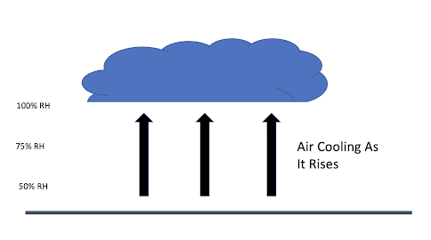
Clouds, like the cumulus clouds shown above, are associated with rising air.
This air starts with a certain amount of moisture but is not saturated--the relative humidity is less than 100% (check my podcast to learn more about saturated air!).
To understand flat cloud bottoms, there are TWO things you have to know:
- Rising air cools. It cools because it is going from higher pressure near the ground to lower pressure aloft, which results in the air expanding...and it takes energy to expand. Ever let the air out of a pressurized bicycle or car tire? It is cool!
- The amount of moisture air can hold depends on temperature. Warm air can hold more water vapor than cool air. Thus, the ascending air can hold less and less water vapor as it rises.
Eventually, the rising air cools to saturation (100%) relative humidity and at that point, water vapor condenses into little cloud droplets. The bottom of the cloud forms.
If the rising air is of relatively uniform temperature and moisture and the vertical motion is also relatively uniform (which is often true on the scale of a cumulus cloud), the rising air will reach saturation about the same level, producing a flat cloud base.
In any case, the result is the typical cauliflower shapes of the upper portions of cumulus clouds.
So flat bottoms and varying tops are typical...and now you know why!
___________________

.png)


Chemical Engineer here - great discussion on relative humidity and dew point. Now can you relate this whole topic to water’s changing vapor pressure with temperature?
ReplyDeleteCliff, for the gardeners among us, to what extent can one use dewpoint to predict frost danger? I imagine that if the dewpoint is above about 35 degrees, fog will form, block IR radiation to space, and prevent a hard frost. Is this a safe guide? (They are predicting frost tonight.)
ReplyDelete