Inversions, in which temperatures INCREASE with elevation, suppress vertical mixing, which in turn allows pollutant concentrations to increase near the surface.
And with a strong inversion over western Washington and Oregon the last few days, air quality has degraded to moderate levels at several locations.
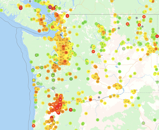
To illustrate, below is a map (at 7 PM today) showing the concentrations of small particles (less than 2.5 millionths of a meter) that are capable of passing deep into your lungs. Nasty stuff.
Low concentrations are green, with moderate values in yellow and orange, and red being even higher. The Puget Sound region has degraded air quality and it is even worse around Portland. Generally good in the mountains.
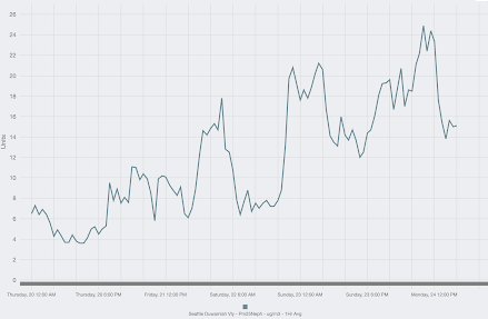
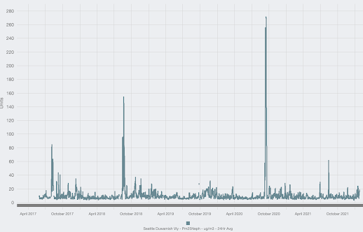
You can see the declining trend of air quality in Seattle with a plot of the small particle concentration during the past few days (below). A progressive upward trend in small particles.
The sources of the particles include combustion from heating, burning of gas and diesel fuels in cars, and from burning wood in fireplaces and wood stoves.
During most winter days, these emissions are little problem around here, with stormy, wind conditions and an atmosphere that facilitates vigorous vertical mixing of air in the lower atmosphere.
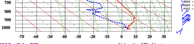
But during the last three days, high pressure aloft has produced a well-defined inversion, as noted in the vertical sounding at Quillayute this morning at 4 AM. (Quillayute is on the northern WA coast)--see below. Red is temperature, the x-axis indicates temperature (°C) and the y axis is height in pressure (700 is about 10,000 ft)
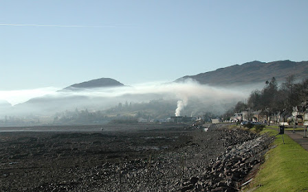
You can think of an inversion as a meteorological barrier to air motion. Here is a beautiful example of what happens when smoke hits a low-level inversion (see below).... it is like hitting an invisible barrier.
The good news is that our winter concentrations are getting lower and lower, as fewer homes burn wood (very dirty), cars and trucks get cleaner, electric cars become more numerous, and with effective burn bans and other restrictions by air quality groups like the Puget Sound Clean Air Agency.
And some other good news...the inversion is weakening and will probably break later today--maybe even with a glimpse of the sun. And stormier conditions will return on Friday.
Prepare to take a deep, healthful breath!


I have asthma and am very sensitive to pollution. I've been looking for a place to go in Washington to avoid the pollution and haven't found one. In many places if you look at daily data you'll see spikes and nearby sites which simultaneously have vast differences. For example, near Winthrop one site is currently near zero and another is 93. Looking at the data for the zero site shows spikes over the last few days up to 150; and the 93 site had lows around 50.
ReplyDeleteIf you're on the west coast, you're west of most pollution sources (given the prevailing westerlies), you rarely get inversions right on the coast, you have an excellent chance of cleansing winds off the ocean most of the year. Winthrop, etc. are all downwind of Pugetopolis... hie thee off to Hoquium or Forks...
DeleteGo to Paradise, Mount baker, or anywhere above 3000 feet.
DeleteBetter yet, Hawaii! I have been wanting to go there myself but he pandemic shut my trip down in 2020.
So why is it that we get this stagnant air in mid-winter here? When I lived in Connecticut, if I remember right we did not have inversions: The wind howled all winter, and it was cold, but at least not polluted.
DeleteHe has done quite a few posts on inversion science before and it's probably better to read those than to listen to my version of it: https://cliffmass.blogspot.com/search?q=inversion
DeleteHis book also covers this (along with lots of other PacNW weather goodies): https://smile.amazon.com/Weather-Pacific-Northwest-Cliff-Mass/dp/0295748443
The northerly flow has had an odd reverse effect near Longview. We've had an hour of sunshine at 750' and fogged in otherwise for several days, while Kelso/Longview has clear skies as the flow warms a bit coming down those hills where we live. It was bizarre yesterday to visit town and see clouds on the hill-tops but clear blue skies below 400 feet!
ReplyDeleteCliff. I view PM2.5 at https://aqicn.org/map/washington/#@g/47.4101/-121.7807/9z. Does anyone measure the relative contributions of wood smoke and vehicles? My neighborhood hasn't gotten the memo on wood fireplaces.
ReplyDeleteMy best solution is a 5 inch thick carbonated MERV 16 filter on my gas furnace.
Is that vertical sounding actual data or forecast data? I know where the forecast data lives (https://a.atmos.washington.edu/wrfrt/rt/otherdates.html) but not the actual data. If anybody knows, please share!
ReplyDelete