After months of jet streams, atmospheric rivers, snowstorms, cold waves, and low centers, a huge persistent ridge of high pressure will soon form along the West Coast.
But you will have to be patient. For three more days, a series of weak systems will bring precipitation to the area. But then the region will turn dry, and in one area, the Pacific Coast, the temperatures will rise to very pleasant levels. Book your room now!
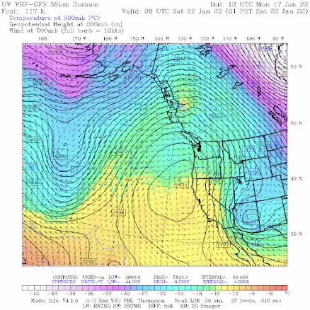
First, the ridge. On Friday, high pressure will explode over the eastern Pacific and by 1 AM Saturday, the mother of all ridges will be evident aloft (500 hPa pressure level, about 18,000 ft) shown below. Two troughs of lower pressure/heights are found on the sides. This produces an OMEGA pattern, which is very stable.
UW Model Forecast for 1 AM Saturday
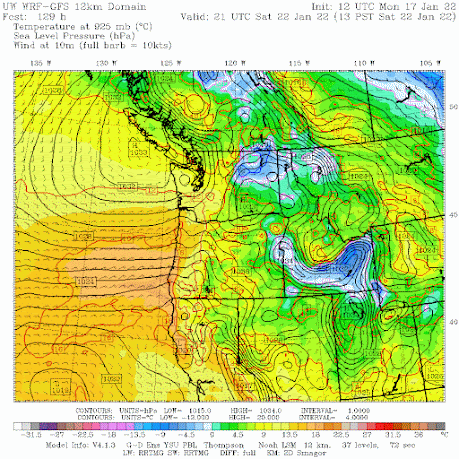
This pattern will hold in for the weekend and beyond. At the surface, high pressure will be centered just offshore of Vancouver Island and inland, producing moderate easterly flow over the coastal zone of Oregon and southwest Washington. Temperatures will warm as air sinks as it moves around the high and down the western slopes of coastal terrain (see sea level pressure map, with low-level temperatures, at 1 PM Saturday).
When I saw this chart I smiled and thought about immediately booking a room somewhere in the "banana belt" of the southern Oregon coast. Let me show you why!
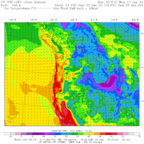
Here is the forecast of surface air temperature for 1 PM Sunday. Lots of reds--temperatures ABOVE 60F--along the coast west of the coastal terrain. Warming offshore flow. And the warmth will extend along the entire Oregon Coast and even southwest Washington (e.g., Long Beach). Folks, it will feel like summer---a guarantee it!
In contrast, below freezing air will be ensconsed in eastern Washington, probably with some fog to boot.
The southern Oregon coast....a.k.a. the Banana Belt...is famous for enjoying warm days in winter. All it takes is easterly (offshore) flow descending the regional terrain.


Sounds like no more snow in the lowlands of Washington...well bring on spring...
ReplyDeleteWhy is it warmer along hood canal than Seattle?
ReplyDeleteMight be perfect weather for some but for winter sports enthusiasts not so much. We only have a few months each year to engage in winter sports yet there's plenty of time for sun/heat during our "climatological drought" from July thru September/October which seems to get longer each year. So only about ~8 weeks of winter left post extended forecast before April and its spring all over again.
ReplyDeleteBring back the jet streams! Bring back the moisture! There is still skiing to be had!
ReplyDeleteThere's still time for more snow hopefully. Early Feb seems to be our sweet spot for that. Is there anything on the long term forecasts Cliff? Or is snow pretty much done for the year?
ReplyDeleteWill it be foggy on the Oregon Coast? It is frustrating to see the box forecasts say it will be clear and sunny in places like Portland, and then in the discussion they say it will be densely foggy. What about places like Port Orford? I cannot tell from the various NWS products.
ReplyDeleteno...with offshore flow it should be sunny!
DeleteThanks! I think I'm taking a trip...
DeleteNWS is going for fog in Seattle. "However, with upper level ridging and
ReplyDeleteresultant sfc high pressure, conditions appear favorable for
widespread lowland fog each morning Friday-Monday. Given the time
of year/sun angle, fog may be stubborn to erode, resulting in a
stagnant pattern, with the potential for some areas to see some
sun shortly in the afternoon." Ugh.
Cliff,
ReplyDeleteI suspect it's too early to comment on yet but, any thoughts on the snow event coming in around February 2nd?
Yeah, I saw that also. It appears there might be some snow on the 3rd. But that's over 15 days out. That's like putting on a blindfold and tossing some dice. :D Then I see the week 7th through the 11th wet snow. I suspect we might get one more squirt (dusting) of snow and that will be it for the winter.
Delete