April 02, 2022

A Powerful Pacific Jet Stream, Heavy Precipitation of the Northwest, and Strong Trade Wind over Hawaii: It is All Connected.

As noted in an earlier blog, a very strong jet stream is developing over the north Pacific Ocean and will result in a quick eastward flight across the Pacific.   The Japan Airlines flight from Tokyo to Seattle did in in less than 8 hours yesterday!

But the atmosphere is interconnected and there are implications of this flow pattern all over the north Pacific.

For example, the circulation that is producing very strong winds from the WEST in the midlatitude jet stream in the upper troposphere (roughly 25,000 to 35000 ft ASL) results in powerful trade winds from the EAST in the subtropics!

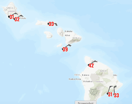
Much of Hawaii is not being buffeted by powerful northeasterly winds, gusting to 30-45 mph (see the plot of winds and gusts at noon PDT). Surf and small craft warnings are now out for much of Hawaii.  Let's say snorkeling will not be very good on the NE side of the islands, but those looking for big waves will be delighted.

Gusts around noon on Sunday (and wind barbs showing direction)

To see the origin of the strong Hawaii winds, below is the sea level pressure forecast for Saturday afternoon.  The red and brown indicated high pressure and greens low pressure.   Strong high pressure is found north of Hawaii, with easterly winds (trade winds) to its south (I indicated the wind direction with a white arrow).


High pressure pressure just to the north of Hawaii is the key for strong trade winds.
But what about the low pressure to the north around 50-60 north latitude?  That low pressure is associated with storms and midlatitude cyclones.     

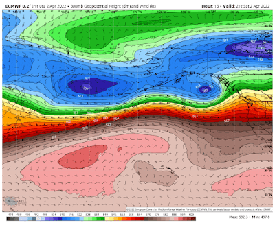
If we go high in the atmosphere, say around 18,000 ft (500 hPa pressure level), you can see a reflection of the surface conditions, with high pressure (or height) to the south and lower pressure (or heights) to the north.


The large change in pressure in a north-south direction is associated with the jet stream...and
 in this stase a very powerful jet stream from the west (see my NW weather book for an explanation on how this works).
So, with the north-Pacific dominated by deep low pressure to the north and high pressure over the subtropics, we get BOTH a strong, very large jet stream from the west and powerful trade winds to the south.  Now you know why.


Finally, with a strong jet stream aimed right at our region, there will be strong upward motion and precipitation on regional terrain....the mountains will be hit hard....and it will be cool enough for heavy snow about 4000 ft (see precipitation for the next three days below--orange is the heavy stuff).


1 comment:

  1. As long as there is no more snow I'm all good haha

    ReplyDelete

Please make sure your comments are civil. Name calling and personal attacks are not appropriate.

Are Eastern Pacific Cyclones Become More Frequent or Stronger?

 During the past three days, I have  received several calls from media folks asking the same question:  Are storms like this week's &quo...