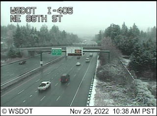
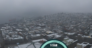
As expected, some light snow came in this morning....a dusting for most and as much as .5-1 inches for favored locations (see below). The roads were warm enough and the air temperatures marginal enough that the snow rapidly melted on most roadway surfaces.
Ironically, the snow is associated with warming aloft.
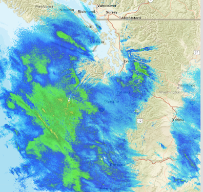
The weather radar this morning around 11 AM showed very light precipitation over the region (blue colors), with heavier precipitation offshore).
Warm air is streaming in aloft as shown by temperature sensors on aircraft taking off and leaving Seattle. And surface temperatures are being warmed by the (weak) sun. Don't expect any low-level snow accumulation during the day.
This warm air aloft is leading a surface warm front, which will get to the coast around 6 PM, with a cold front a few hours behind.
So there will be a few light flakes in the air today, but nothing that will be substantial.
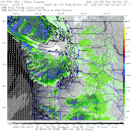
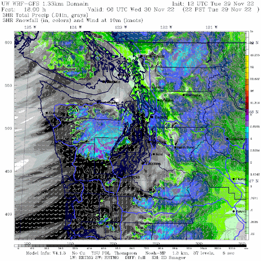
As precipitation increases on the coast later this afternoon, the higher intensity will drive down the snow level and produce some snow around the Olympics (see 3-h totals ending 4 PM below: rain is black and gray, snow in color). The Kitsap will be favored as southeasterly flow rises on the eastern slopes. Rain on the coast at that time.
And then a burst of wet snow from Lynnwood to Everett around 10 PM as the frontal moves through and warm air moves in (see below). It will all melt overnight. And it will seem warm when you wake up tomorrow.
Disappointed? Would you be interested in hurricane-force winds?
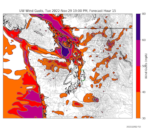
Then head to NW Washington this evening. The approaching front, interacting with the Olympic Mountains, will produce powerful southeasterly winds over Northwest Washington (see gust forecast for 7 PM tonight below).
If you take the Victoria Clipper tonight, bring your sickness bag...
Finally, I am watching the next interesting situation. By 10 PM Wednesday ANOTHER low-pressure center will move down the coast to NW Oregon, drawing in cool air over the region again (see below).
A little too far south to bring snow to Seattle and NW Washington, but Portland and SW Washington could get some white action. Will watch it....


Should we expect any strong gap winds out in Gold Bar? Or a substantial amount of snowfall out here?
ReplyDeleteYour snow forecast looks similar to Everett - a few inches this evening / overnight, but transitioning to rain by morning.
DeleteIt looks like Gold Bar will have see stronger winds than most inland areas, but not as nearly as bad as around Port Angeles - Victoria - Friday Harbor.
The current UW gust forecast map suggests 30-35 knot gusts around Gold Bar around 8 PM this evening. That could be enough to cause some power outages, but the storm a few weeks ago already brought down a lot of this season's weak trees. It looks like it will be coming from the east, so it will be bitter.
https://a.atmos.washington.edu/wrfrt/data/2022112912/load.cgi?images_d4/ps_wgsfc.16.0000.gif
5" here in whatcom countty, still dumping
DeleteThe low moving tonight looks to bring 40 to 50mph winds even to central seattle area. Normally this would be a 'wind storm' plastered all over the news, but seems to be ignored mostly this time around.
ReplyDeleteCan we expect a snowy winter since we're in la Nina or is this it?, I know la Nina is expected to weaken mid to late winter as well.
ReplyDeleteMeteorologists are going to have their hands full just figuring out this next week. The rest of the coming winter might as well be a trip to the casino. Plus, if La Nina subsides, than it's the randomness of La Nada if anything. The neutral periods are supposedly more windstorm prone and the low snow chances are more random instead of just plain eliminated. The local newsies commented today that the public want to know what is going to happen at THEIR area but this region with all it's variables make that a next to impossible task. All the water, mountains, microclimates etc. You would almost be better off asking the old guy down the road that has lived in your neighborhood 30 years what the weather might do.
DeleteTim, winter hasn't even started yet. If you don't already, you should know that it's impossible to predict specific weather events in advance of the season.
DeleteInteresting the Winter Storm Warning for Hood Canal got cancelled, and here at 500' it is snowing harder than it has all day, and is now making for a decent accumulation in the last 2 hours, after just sort of steady light flurries all day.
ReplyDeleteAt this rate it will meet warning criteria by 7 or 8 pm.
Now at 7.5" and nearly an inch an hour with wind.
DeleteCliff, could you send copy of your last two blogs to Alaska Airlines? :-)
ReplyDeleteI think that there is a "h" too much in the title. Should it be "Snow Treat"?
ReplyDeleteWhat about Friday? NOAA forecasts 1-2 inches of snow. weather.com is not that optimistic.
4 inches at 450 feet in Silverdale/Seabeck, still heavy wet snow as of this post. Probs change to rain before too long.
ReplyDeleteMake it 5 inches. surprised the canceled the winter storm warning here...
ReplyDeleteOnce again, as we've seen before, the snow is holding on a bit longer than I expected here with the heavy precipitation. Branches starting to crack.
ReplyDeleteHeavy Snow in Everett all the way up to Smokey Point exit in Arlington. looks like 2-4 inches and sticking to the pavement. Still waiting for it to switch to rain. Paine Field looks to be covered on their webcam as well.
ReplyDeleteHere in redmond wa the temp had jumped up to 33/34 but in the last hour the temp has dropped to 31 with a dew point of 30 and nuking snow. Several inches have fallen now. Was a north east wind expected? It seems to be shooting coler air out of the mountain gaps to us all of sudden here on the Eastside.
ReplyDelete5-6 inches fell last evening, and into this early am...quiet, and beautiful to look at now...the predictions were spot on for the Everett area...I hope this snow gets scoured out by rain today..
ReplyDelete"And it will seem warm when you wake up tomorrow."
ReplyDeleteUnfortunately, no. It's 34 degrees now and was 34 degrees last night when I went to bed.
Snowed all day at 450' in Woodinville; six inches fell by the time I went to sleep. This morning the snow had started to melt but the roads were still covered with 4 or 5 inches of wet, heavy snow. Just 1 mile away and 200' down the hill, the roads were wet and clear.
ReplyDeleteI realize we live in a region where predicting snowfall is really difficult, but nobody got it right this time. Predictions were that snow would change to rain in the afternoon, however in north Lynnwood we had snow all day, till midnight at least. Accumulated around 6 inches!! It's very pretty, just not expected.
ReplyDeleteAbout 3 inches of wet snow on the Bothell-Mill Creek line last night.
ReplyDeleteNovember just loves to slam us almost every year. It's a weird climate: Winter runs November to February, earlier than most places, but summer is later than most places.
ReplyDelete