My new podcast is out.
In the second segment, I talk about regional freezing rain events and reveal which areas of the Northwest are world-class in the ice storm domain (see map below for a hint).
In the first segment, I talk about the forecast.
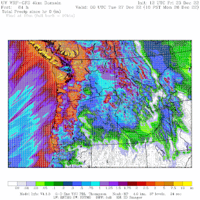
Major changes are ahead, including massive amounts of rain in the mountains! Here is the forecast precipitation through 4 PM Monday. Wow. Up to approximately 10 inches in the mountains.
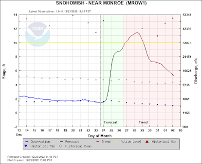
Enough rain that some rivers will get near their daily records (see an example of the Snohomish below)


Cliff, I live in Bellingham and as you know we had a significant ice storm today which has persisted longer than expected to a lack of forecast warming. At 7:23PM the temperature at my location was 31.4F and at 7:28PM one of my rain gauges recorded 0.01" of rain - presumably due to melting of the ice and snow accumulated in the collector. At 7:31PM the temperature still stood at 31.4F but then, over the next 33 minutes, the temperature fell 1.1F to 30.3F. I didn't observe any noticeable change in wind speed or direction or any other parameters that might have induced this temperature drop - which is ongoing as I write this message. Do you think that the falling temperature could be a result of the latent heat of fusion of the substantial amount of accumulated ice and snow as it approached the melting point and then began to cool the ambient air as heat from the air was absorbed by the ice and snow as it started to melt? It would be interesting if the process of melting of ice and snow in temperatures just barely near the melting point resulted in sufficient heat being removed from the air such that a feedback mechanism occurred which actually induced cooling of the ambient air temperature back below the melting point of water. I would love to know your thoughts about this! P.S. As of 8:17PM the temperature has continued to cool and is now 29.9F
ReplyDeleteThe temperature went down because cooler air moved back in to the area. Similar thing happened at my weather station and other weather stations in the area. Also, after the sun set, it got cooler. Hard to imagine that melting snow in the rain gauge would affect the temperature sensor.
DeleteJust a short follow-up on some other reasons your refrigeration cycle is very unlikely to affect the temperature sensor in your weather station. Not sure what make you have, but the Davis tipping bucket rain gauge tips once for each .01" of rain, which, due to the funnel shape of the collector, requires 4ml/4gr of water. 1 calorie of heat (not kilo-calorie) is absorbed for each gram of snow melt for a total of ~16 calories for each .01" melted snow water, which is just a very small amount of cooling. In addition, I am assuming the temperature sensor is located some distance from the melting snow and would be unlikely to be affected by this small and transitory cooling effect. The sensor software is likely to have some kind of smoothing function that does not show minor temperature variations. I freely acknowledge my strictly and potentially flawed pedestrian analysis.
DeleteDr Mass, I have a question. Yesterday, I took some macro pictures of ice accumulation on top of a fence post in my backyard. There was a pattern in the very clear ice that (as best I can describe it) looked like a turtle shell. The pattern was irregular with some spots being up to 10 mm in diameter and some down to 3 mm. I live near Graham and we ended up with about 25-30 mm of ice accumulation. A brief search online produced no answers as to what conditions allowed this to happen. Can you enlighten me? Thank you.
ReplyDeleteThis comment has been removed by a blog administrator.
ReplyDeleteThis comment has been removed by a blog administrator.
ReplyDelete