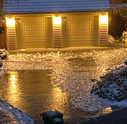
As predicted, a major freezing rain event has occurred over western Washington. In fact, this is probably the most severe freezing rain occurrence in western Washington since December 1996.
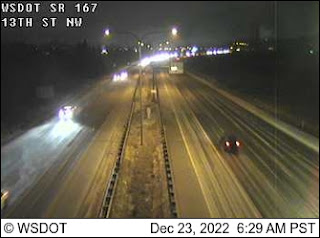
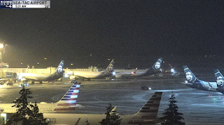
With a glaze of ice, even walking is challenging, roads are treacherous, SeaTac runways are closed, bus service is canceled over the region, and some major highway sections are closed (such as I-90 west of 405). Good advice: stay home until 1 PM.
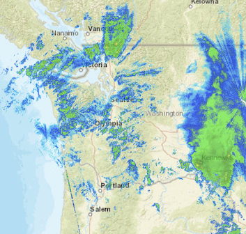
The major frontal band is now moving out, but there are showers behind it, as evident on the latest radar image. That means some scattered freezing rain showers for a few more hours, since low-level temperatures are still below freezing for most of the region except for the coast.
When will we thaw out? Between noon and 4 PM today for most residents of the lowlands, so there are several more hours of this icy mess....so please don't travel if you can avoid it.
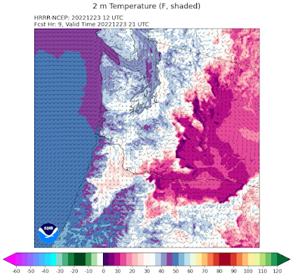
Here are the surface air temperature forecasts from the latest NOAA HRRR model predictions (pink and reds are below freezing, with white near freezing)
10 AM: Still problems for most, but improving over the coast and NW WA.



I'm a pretty savvy snow driver, having been raised in the Midwest. When it was 16 degrees, I was the one doing the speed limit (legally) passing people driving at 20 because I understood that the deep freeze had improved traction. I was still cautious of course, but conditions were pretty great on most of the main roads.
ReplyDeleteBut this morning, count me out. I'm cat sitting for friends out of town, and regretfully the poor kitties have to starve until this evening. Until it's slushy and 38, I have no intention whatsoever of risking life and limb by going anywhere.
Your friends didn't leave you enough food for them? I'd be a little put out by that. I'd never ask someone to watch my cat and not leave enough food.
DeleteI'm sorry, I wasn't clear. I'm not staying in their house, but making daily visits. There's plenty of cat food in the house, but without opposable thumbs to open the cans, I don't expect the kitties to make much headway,
DeleteGood job on keeping us posted. Ice "storms" are a bit insidious because they tend to happen in slow motion. It is easy to go outside and think this is no big deal. Unlike wind and other storms where the severity of the event is obvious, with ice storms the ice build-up can be fairly slow until it reaches the breaking point. So far, reported outages from PSE and the City of Seattle are fairly minor, but Snohomish PUD is beginning to report a fair number with close to 6,000 customers affected. Here in Bellingham, there has not been much warming with winds still out of the north.
ReplyDeleteAlthough the rain has at least temporarily stopped here, it is still slow to warm and as long as the surface winds remain out of the north, it will have a hard time getting above freezing. NWS is already pushing out the thaw times for Whatcom County compared to the earlier forecast. If you look at some of the NWS reporting stations on the eastern and northern part of the Olympic Peninsula at altitudes of 2400 feet, the temperatures are currently at 40F:
Deletehttps://www.weather.gov/wrh/timeseries?site=TOFW1&hours=72
https://www.weather.gov/wrh/timeseries?site=CGFW1&hours=72
Stations below 1,000 feet in this area remain below freezing. We need some of that warm Pacific air to get through the straits.
It's nasty in Tacoma too, icy as hell here. I can see it outside, but had to venture out to the electrical panel out back and the steps off my porch are very, very icy so held onto the railing with both hands and went gingerly down the steps and gingerly stepped onto the icy walkway to get to the grass that was nearby and once on the grass, it wasn't too bad and got the circuit breaker reset (dishwasher is on the same circuit as the laundry room, and I have to run an oil space heater on that same circuit and the outdoor lights were on, thanks to the photocell and the deck's roofing and ran it, forgetting to turn down the space heater) but got it back on and back indoors without a hitch, thankfully.
ReplyDeleteI remember that ice storm from 1996. Even tried to tape the news stories that ran all day that Sunday as rains kept coming and the ice layers from the previous thaws and refreezes put tremendous weight on marinas, carports etc and caused a lot of damage. Unfortunately, my VCR at the time had a color processor issue so it all came out in B&W. :-(
I see the occasional car out and about but I think most folks are staying home right now. Many businesses can't open due to the ice.
Weve been fortunate so far, just a light glaze of sleet near Longview.
ReplyDeleteNo icicles and little precip at all - but still staying home.
I learned to drive (officially) in a car fitted with tire chains. I have also been caught out in an ice storm without them.
ReplyDelete10 AM Ellensburg temp is 9°F.
We are at 1000 ft on the Eastside and the temperature just jumped 10 degrees to 38. Warmer than down in the valley. Just like your freezing rain illustration showed. Strange having things thaw from higher to lower elevations. Shoe chains work very well on the ice, recommended.
ReplyDeleteso far this ice storm is not the same in intensity or length in comparison to the massive one we experienced here in Portland less than two years ago. That one came in waves over 48 - 72 hours, leaving almost two inches of ice encrusted everywhere. It took the utility companies days just to chop up and clear out all of the trees and fallen branches in the roads, and only then could they start to restart the grid. We'll see if PGE does any better this time.
ReplyDeleteI don't know about the most severe event since 1996.., the 2012 freezing rain event left tens of thousands without power for days. PSE's outage map shows less than 10,000 without power, and the outages are scattered, not widespread.
ReplyDeletethough temps are warming the forecast rain seems to be slow to arrive. I feel like most of us will be homebound until tomorrow AM at the earliest (Sat)
ReplyDelete1996 and 2012 was much worse in the south sound. I had 2 inches of ice in Puyallup during the 2012 event and it took a few days to melt.
ReplyDeleteWe are getting very large amounts of accumulating ice here in Bellingham near the airport. I have begun to hear some tree limbs breaking. We live on 2.5 acres with lots of evergreens and deciduous trees. There are areas on the ground that have puddled and refrozen with at least a half inch of ice. Many shrubs, like Rhododendrons, are bending severely and likely to break. I would say that the forecasts for this part of the county are a miss at this point, in terms of the amount of freezing precipitation, duration and timing of the warm-up. Whether the forecast is off or not does not really make much difference, as there is virtually nothing to be done. I do worry about ice accumulations on roofs. The temperature has been stuck at 28F. Earlier forecasts had it above freezing by now. The PSE outage map still not showing much. As said before, I would be concerned for the northern part of the county as it is likely to be cold much longer.
ReplyDelete3pm and 37 here in Olalla, about 500 foot elevation; the ground is still cold enough that no significant melting has occurred...ice sheets everywhere. I'm glad to be able to stay inside.
ReplyDeleteIce is quite visibly accumulating here on trees east of Vancouver, BC.
ReplyDeleteIt finally got above freezing this morning, about 18 hours later than previously forecast. It was still at freezing at 5:15 am. Persistence is an apt word for these Frazier River outflow cold weather events. They always seem to last longer than what the forecasters predict. One would think that historical insight would provide a great role in the predictions, but they always seem off. Not sure about the extent to which the models incorporate this. We had a couple of light flickers last night, but did not lose power. However, PSE reports around 5% of its Whatcom County customers are out. Most of this is in the northern part of the county.
ReplyDeleteI am N7DTY (ham radio call letters) and use a Davis weather station in the NWS CWOP reporting system:
https://www.weather.gov/wrh/timeseries?site=AV482